Related Research Articles

Physical geography is one of the two fields of geography. Physical geography is the branch of natural science which deals with the study of processes and patterns in the natural environment such as the atmosphere, hydrosphere, biosphere, and geosphere, as opposed to the cultural or built environment, the domain of human geography.
Pedology is a discipline within soil science which focuses on understanding and characterizing soil formation, evolution, and the theoretical frameworks through which we understand a soil body(s), often in the context of the natural environment. Pedology is often seen as one of two main branches of soil inquiry, the other being edaphology which is traditionally more agronomically oriented and focuses on how soil properties influence plant communities. In studying the fundamental phenomenology of soils, e.g. soil formation, pedologists pay particular attention to observing soil morphology and the geographic distributions of soils, and the placement of soil bodies into larger temporal and spatial contexts. In so doing, pedologists develop systems of soil classification, soil maps, and theories for characterizing temporal and spatial interrelations among soils. There are a few noteworthy sub-disciplines of pedology; namely pedometrics and soil geomorphology. Pedometrics focuses on the development of techniques for quantitative characterization of soils, especially for the purposes of mapping soil properties whereas soil geomorphology studies the interrelationships between geomorphic processes and soil formation.

Soil science is the study of soil as a natural resource on the surface of the Earth including soil formation, classification and mapping; physical, chemical, biological, and fertility properties of soils; and these properties in relation to the use and management of soils.
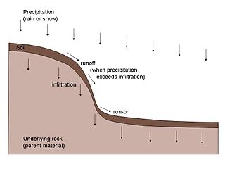
Pedogenesis is the process of soil formation as regulated by the effects of place, environment, and history. Biogeochemical processes act to both create and destroy order (anisotropy) within soils. These alterations lead to the development of layers, termed soil horizons, distinguished by differences in color, structure, texture, and chemistry. These features occur in patterns of soil type distribution, forming in response to differences in soil forming factors.
This is a list of all articles related to geology that cannot be readily placed on the following subtopic pages:

Gelisols are an order in USDA soil taxonomy. They are soils of very cold climates which are defined as containing permafrost within two meters of the soil surface. The word "Gelisol" comes from the Latin gelare meaning "to freeze", a reference to the process of cryoturbation that occurs from the alternating thawing and freezing characteristic of Gelisols.
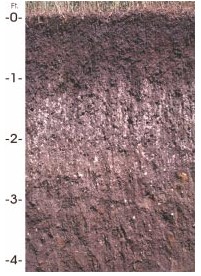
A soil horizon is a layer parallel to the soil surface whose physical, chemical and biological characteristics differ from the layers above and beneath. Horizons are defined in many cases by obvious physical features, mainly colour and texture. These may be described both in absolute terms and in terms relative to the surrounding material, i.e. ‘coarser’ or ‘sandier’ than the horizons above and below.
This is an index of articles relating to soil.

In geology, a terrace is a step-like landform. A terrace consists of a flat or gently sloping geomorphic surface, called a tread, that is typically bounded on one side by a steeper ascending slope, which is called a "riser" or "scarp". The tread and the steeper descending slope together constitute the terrace. Terraces can also consist of a tread bounded on all sides by a descending riser or scarp. A narrow terrace is often called a bench.

Mima mounds are low, flattened, circular to oval, domelike, natural mounds that are composed of loose, unstratified, often gravelly sediment that is an overthickened A horizon. These mounds range in diameter from 3 to more than 50 m; in height 30 cm to greater than 2 m; and in density from several to greater than 50 mounds per hectare, at times forming conspicuous natural patterns. Mima mounds can be seen at the Mima Mounds Natural Area Preserve in Washington state.
The early concepts of soil were based on ideas developed by a German chemist, Justus von Liebig (1803–1873), and modified and refined by agricultural scientists who worked on samples of soil in laboratories, greenhouses, and on small field plots. The soils were rarely examined below the depth of normal tillage. These chemists held the "balance-sheet" theory of plant nutrition. Soil was considered a more or less static storage bin for plant nutrients—the soils could be used and replaced. This concept still has value when applied within the framework of modern soil science, although a useful understanding of soils goes beyond the removal of nutrients from soil by harvested crops and their return in manure, lime, and fertilizer.

Subaqueous soils are soils formed in sediment found in shallow, permanently flooded environments or soils in any areas permanently covered by water too deep for the growth of rooted plants.
Houdek is a type of soil composed of glacial till and decomposed organic matter. The soil series was established in 1955 in Spink County, South Dakota. It is unique to the United States, but in particular to South Dakota where it is the state soil.
Earth science, is an all-embracing term for the sciences related to the planet Earth. It is arguably a special case in planetary science, the Earth being the only known life-bearing planet. There are both reductionist and holistic approaches to Earth science. There are four major disciplines in earth sciences, namely geography, geology, geophysics and geodesy. These major disciplines use physics, chemistry, biology, chronology and mathematics to build a quantitative understanding of the principal areas or spheres of the Earth system.
A gilgai is a small, ephemeral lake formed from a depression in the soil surface in expanding clay soils. Additionally, the term "gilgai" is used to refer to the overall micro-relief in such areas, consisting of mounds and depressions, not just the lakes themselves. The name comes from an Australian Aboriginal word meaning small water hole. These pools are commonly a few metres across and less than 30 cm (12 in) deep, however in some instances they may be several metres deep and up to 100 m (330 ft) across. Gilgais are found worldwide wherever cracking clay soils and pronounced wet and dry seasons are present. Gilgais are also called "melonholes, crabholes, hogwallows or puff and shelf formations".
The soil biomantle can be described and defined in several ways. Most simply, the soil biomantle is the organic-rich bioturbated upper part of the soil, including the topsoil where most biota live, reproduce, die, and become assimilated. The biomantle is thus the upper zone of soil that is predominantly a product of organic activity and the area where bioturbation is a dominant process. Soil bioturbation consists predominantly of three subsets: faunalturbation, floralturbation, and fungiturbation. All three processes promote soil parent material destratification, mixing, and often particle size sorting, leading with other processes to the formation of soil and its horizons. While the general term bioturbation refers mainly to these three mixing processes, unless otherwise specified it is commonly used as a synonym to faunalturbation.
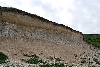
A stone line is a three-dimensional subsurface layer, or ‘carpet,’ of stones evident as a ‘line of stones’ in natural exposures such as soils, road cuts, and trenches. Stone lines that are more than one stone thick have been called ‘stone zones’. Stone lines and stone zones are known to occur in soils, paleosols, and in non-soil geologic-stratigraphic sequences. Where present in stratigraphic sequences, if the units were deposited by running water, the stones are usually imbricated. This is strong evidence that such stone lines are geogenic. On the other hand, a stone line that is present in a soil or a paleosol is invariable non-imbricated and follows (mimics) the surface topography of the soil, or the paleosurface of a paleosol. This is strong evidence that such stone lines are pedogenic, and produced by soil forming processes. As it turns out, experience has shown that most stone lines are indeed associated with soils and paleosols, and most are consequently assumed to be pedogenic. How stone lines form, whether geogenically by geologic processes or pedogenically by soil forming processes is invariably a matter of interpretation. And whether the interpretation is geogenic or pedogenic often reflects the background and training of the interpreter.
The Kirk Bryan Award is the annual award of the Quaternary Geology and Geomorphology Division of the Geological Society of America. It is named after Kirk Bryan a pioneer in geomorphology of arid regions. The award was established in 1951 and is bestowed upon the author or authors of a published paper of distinction advancing the science of geomorphology or some related field.
A catena in soil science (pedology) is a series of distinct but co-evolving soils arrayed down a slope. Each soil type or "facet" differs somewhat from its neighbours, but all occur in the same climate and on the same underlying parent material. A mature catena is in equilibrium as the processes of deposition and erosion are in balance.
In geology, the term relict refers to structures or minerals from a parent rock that did not undergo metamorphic change when the surrounding rock did, or to rock that survived a destructive geologic process.
References
Aleva, G.J.J. 1983. On weathering and denudation of humid tropical interfluves and their triple planation surfaces. Geologie en Mijnbouw, v. 62, pp. 383–388.
Aleva, G.J.J. 1987. Occurrence of stone-lines in tin-bearing areas in Belitung, Indonesia, and Rondônia, Brazil. Géo-Eco-Trop, v. 11, pp. 197–203.
Birkeland, P.W. 1974. Pedology, Weathering, and Geomorphological Research. Oxford University Press, London and New York.
Birkeland, P.W. 1984. Soils and Geomorphology. Oxford University Press, London and New York.
Brink, A. B. A., T. C. Partridge, and A. A. B. Williams. 1982. Soil Survey for Engineering. Clarendon Press, Oxford, U.K.
Brink, A.B.A. 1985. Engineering Geology of Southern Africa 4: Post-Gondwana Deposits. Building Publications, Pretoria, South Africa.
Darwin, C. 1840. On the formation of mould: Transactions, Geological Society of London, v. 5, pp. 505–509. (A republication of his 1837/38 paper)
Darwin, C. 1881. The formation of vegetable mould through the action of worms. John Murray, London, and Appleton, NY (facsimiles published in 1982 and 1985 by University of Chicago Press, Chicago).
Fey, M.V. 2009. Soils of South Africa. Stellenbosch University, Stellenbosch, So. Africa. (Craft Printing International, Ltd, Singapore).
Hartt, C.F. 1870. Geology and Physical Geography of Brazil. Fields, Osgood, & Co., Boston.
Hartt, C.F. 1871. Amazonian drift. American Journal of Science (Ser. 3), v. 1, pp. 294–296.
Jenny, H. 1941. Factors of Soil Formation, McGraw Hill Co., N.Y.
Johnson, D.L. 1989. Subsurface stone lines, stone zones, artifact manuport layers, and biomantles produced by bioturbation via pocket gophers (Thomomys bottae). American Antiquity, v. 54, pp. 292 326.
Johnson, D.L. 2002. Darwin would be proud: Bioturbation, dynamic denudation, and the power of theory in science. Geoarchaeology, an International, v. 17 (1-2), pp. 7–40, 631-632.
Johnson, D.L. and D.N. Johnson. 2006. Why have stonelayers been assumed to be geogenic by so many for so long? Abstracts, American Society of Agronomy National Meetings, Nov. 12-16, Indianapolis IN (online).
Johnson, D.L., J.E.J. Domier, and D.N. Johnson. 2005. Reflections on the nature of soil and its biomantle. Annals, Association of American Geographers, v. 95 (1), pp. 11–31.
Morrás, H., L. Moretti, G. Píccolo, and W. Zech. 2009. Genesis of subtropical soils with stony horizons in NE Argentina: Autochthony and polygenesis. Quaternary International, v. 196 (1-2), pp. 137–159.
Paton, T.R., G.S. Humphreys, and P.B. Mitchell. 1995. Soils, A New Global View. Yale University Press, New Haven and London.
Ruhe, R.V. 1959. Stone lines in soils. Soil Science, v. 84, pp. 223–231.
Ruhe, R.V. 1969. Quaternary Landscapes in Iowa. Iowa State University Press, Ames, Iowa.
Schaetzl, R.J. and S. Anderson. 2005. Soils—Genesis and Geomorphology. Cambridge University Press, U.K.
Shaler, N.S. 1891. The origin and nature of soils. United States Geological Survey 12th Annual Report 1890-1891, part 1, pp. 213–345.
Sharpe, C.F.S. 1938. Landslides and related phenomena. Columbia University Press, N.Y.
Soil Survey Staff. 1937. Soil Survey Manual. U. S. Department of Agriculture Miscellaneous Publication 274. U.S. Government Printing Office, Washington, D.C.
Soil Survey Staff. 1951. Soil Survey Manual (2nd ed.). U.S. Department of Agriculture Handbook no. 18. U.S. Government Printing Office, Washington, D.C.
Soil Survey Staff. 1975. Soil Taxonomy: A Basic System of Soil Classification for Making and Interpreting Soil Surveys. Agricultural Handbook no. 436. Soil Conservation Service, U.S. Department of Agriculture, U.S. Government Printing Office, Washington, D.C.
Soil Survey Staff. 1993. Soil Survey Manual (3rd ed.). U.S. Department of Agriculture Handbook no. 18. Washington, D.C., U.S. Government Printing Office, Washington, D.C.
Soil Survey Staff. 1999. Soil Taxonomy: A basic System of Soil Classification for Making and Interpreting Soil Surveys (2nd. ed.). Handbook no. 436. U.S. Department of Agriculture, Natural Resources Conservation Service, Washington, D.C.
Webster, C.L. 1888. On the glacial drift and loess of a portion of the northern-central basin of Iowa. American Naturalist, v. 22, pp. 972–979.
Wilkinson, M.T., P.J. Richards, and G.S. Humphreys. 2009. Breaking ground: pedological, geological, and ecological implications of soil bioturbation Earth-Science Reviews, v. 97 (1-4), pp. 257–272.