Related Research Articles
Interstate 35 (I-35) is a major Interstate Highway in the central United States. As with most interstates that end in a five, it is a major cross-country, north-south route. It stretches from Laredo, Texas, near the Mexican border to Duluth, Minnesota, at Minnesota State Highway 61 and 26th Avenue East. The highway splits into I-35E and I-35W in two separate places, the Dallas–Fort Worth metroplex in Texas and at the Minnesota twin cities of Minneapolis–Saint Paul.

Jackson County is located in the western portion of the U.S. state of Missouri. As of the 2010 census, the population was 674,158. The estimated population in 2019 is 703,011 making it the second-most populous county in the state. Although Independence retains its status as the original county seat, Kansas City serves as a second county seat and the center of county government. The county was organized December 15, 1826, and named for President Andrew Jackson. Jackson County is the most populated county in the Kansas City metropolitan area. Total employment in 2016 was 338,535.
Independence is the fifth-largest city in Missouri. It lies within Jackson County, of which it is the county seat. Independence is a satellite city of Kansas City, Missouri, and is the largest suburb on the Missouri side of the Kansas City metropolitan area. In 2010, it had a total population of 116,830.

U.S. Route 40 or U.S. Highway 40 (US 40), also known as the Main Street of America, is a major east–west United States Highway traveling across the United States from the Mountain States to the Mid-Atlantic States. As with most routes whose numbers end in a zero, US 40 once traversed the entire United States. It is one of the first U.S. Highways created in 1926 and its original termini were in San Francisco, California and Atlantic City, New Jersey. In the western United States, US 40 was functionally replaced by Interstate 80 (I-80), resulting in the route being truncated multiple times. US 40 currently ends at a junction with I-80 in Silver Summit, Utah, just outside Salt Lake City.
U.S. Route 24 (US 24) is one of the original United States highways of 1926. It originally ran from Pontiac, Michigan, in the east to Kansas City, Missouri, in the west. Today, the highway's eastern terminus is in Independence Township, Michigan at an intersection with I-75, and its western terminus is near Minturn, Colorado at an intersection with I-70. The highway transitions from north–south to east–west signage at the Ohio-Michigan state line.
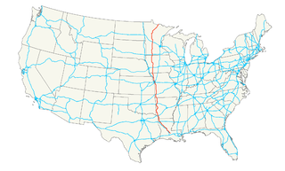
U.S. Route 71 or U.S. Highway 71 is a major north–south United States highway that extends for over 1500 miles (2500 km) in the central United States. This original 1926 route has remained largely unchanged by encroaching Interstate highways. Currently, the highway's northern terminus is in International Falls, Minnesota at the Canada–US border, at the southern end of the Fort Frances-International Falls International Bridge to Fort Frances, Ontario. U.S. Route 53 also ends here. On the other side of the bridge, Trans-Canada Highway is an east–west route while Highway 71 is a north–south route. US 71's southern terminus is between Port Barre and Krotz Springs, Louisiana at an intersection with U.S. Route 190. For the entirety south of Kansas City, Missouri, US 71 runs parallel and concurrent with the existing and future Interstate 49. North of Kansas City, US 71 runs halfway between Interstate 29 and Interstate 35, which they split in the city at an interchange with Interstate 70.

The Kansas City metropolitan area is a bi-state metropolitan area anchored by Kansas City, Missouri. Its 14 counties straddle the border between the U.S. states of Missouri and Kansas. With 8,472 square miles (21,940 km2) and a population of more than 2.1 million people, it is the second-largest metropolitan area centered in Missouri and is the largest metropolitan area in Kansas, though Wichita is the largest metropolitan area centered in Kansas. Alongside Kansas City, Missouri, these are the suburbs with populations above 100,000: Overland Park, Kansas; Kansas City, Kansas; Olathe, Kansas; Independence, Missouri; and Lee's Summit, Missouri.

U.S. Route 36 (US 36) is an east–west United States highway that travels approximately 1,414 miles (2,276 km) from Rocky Mountain National Park, Colorado to Uhrichsville, Ohio. The highway's western terminus is at Deer Ridge Junction, an intersection in Rocky Mountain National Park, Colorado, where it meets US 34. Its eastern terminus is at US 250 in Uhrichsville, Ohio.
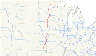
U.S. Route 169 is a north-south U.S highway that currently runs for 966 miles (1,555 km) from the city of Virginia, Minnesota to Tulsa, Oklahoma at Memorial Drive.

Route 13 is a highway in Missouri which runs almost the entire north–south length of the state. Its northern terminus is at U.S. Route 69/136 in Bethany. Its southern terminus is at the Arkansas state line in downtown Blue Eye, Missouri–Arkansas where it continues as Highway 21. It is one of the original state highways of Missouri.
Route 291 is a state highway in the western part of the U.S. state of Missouri. Its southern terminus is at I-49/US 71 in Harrisonville; its northern terminus is at I-435 in Kansas City. The route was once designated as US 71 Bypass. Route 291 serves as a main arterial road and commercial strip in Liberty and Independence.
Route 12 is a short highway in the Kansas City metropolitan area. Its eastern terminus is at Spring Street in Independence. Its western terminus is at Interstate 435 at the eastern edge of Kansas City. The highway is known as Truman Road in Independence, Missouri and passes by the home of Harry S. Truman.
Interstate 470 (I-470) is a 16.72-mile (26.91 km) loop of the Interstate Highway System that serves to link southeast Kansas City to Independence via Lee's Summit in Jackson County, Missouri. The western terminus of the freeway is at the Grandview Triangle interchange with I-49, I-435, U.S. Route 50 (US 50), and US 71 while the northern terminus is a cloverleaf interchange with I-70. The freeway travels west to east through southern Kansas City, curving towards the north at the Lee's Summit Municipal Airport and becoming concurrent with Missouri Route 291 as the highway travels north towards Independence.
Blue Summit is an unincorporated community and census-designated place (CDP) lodged between Kansas City and Independence in Jackson County, Missouri, United States. It is part of the Kansas City metropolitan area.

Robert Thompson Van Horn was an American lawyer, the owner and publisher of The Kansas City Enterprise, mayor of Kansas City, Missouri during the parts of the Civil War, member of the Missouri General Assembly, and representative to the Forty-seventh Congress of the United States.
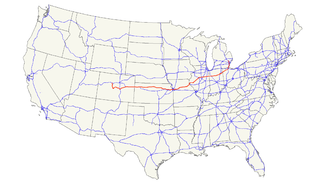
In the U.S. state of Missouri, Interstate 70 (I-70) is generally parallel to the Missouri River. This section of the transcontinental Interstate begins at the Kansas state line on the Lewis and Clark Viaduct, concurrent with U.S. Routes 24, 40, and 169, and the east end is on the Stan Musial Veterans Memorial Bridge in St. Louis.
A total of ten special routes of U.S. Route 71 exist.
U.S. Route 81 (US-81) is a north–south U.S. highway running through the central United States' Great Plains region, from Fort Worth, Texas to the U.S.–Canadian border at Pembina, North Dakota. A 229.28-mile (368.99 km) segment of the highway lies within the state of Oklahoma. US-81 crosses the Red River from Texas south of Terral, passing through several Oklahoma cities, such as Chickasha, El Reno, Kingfisher, and Enid, before entering Kansas north of Renfrow.
A total of eight special routes of U.S. Route 65 exist, divided between the U.S. states of Arkansas and Missouri. Currently, they are all business loops, although a spur route in Pine Bluff, Arkansas and bypass routes in Baton Rouge, Louisiana and Springfield, Missouri both existed in the past.
The Fort Osage R-1 School District is a public school district located in Jackson County, Missouri, in the Kansas City metropolitan area. The district headquarters is in an unincorporated area adjacent to the City of Independence. The district serves a section of northern Independence, the City of Buckner, the City of Levasy, and the City of Sibley.
References
Coordinates: 39°5′38.6″N94°25′23.8″W / 39.094056°N 94.423278°W
| | This Missouri road-related article is a stub. You can help Wikipedia by expanding it. |