
The Connecticut River is the longest river in the New England region of the United States, flowing roughly southward for 406 miles (653 km) through four states. It rises at the U.S. border with Quebec, Canada, and discharges at Long Island Sound. Its watershed encompasses 11,260 square miles (29,200 km2), covering parts of five U.S. states and one Canadian province, via 148 tributaries, 38 of which are major rivers. It produces 70% of Long Island Sound's fresh water, discharging at 18,400 cubic feet (520 m3) per second.
Deerfield River is a river that runs for 76 miles (122 km) from southern Vermont through northwestern Massachusetts to the Connecticut River. The Deerfield was historically influential in the settlement of western Franklin County, Massachusetts, and its namesake town. The Deerfield River is the Connecticut River's second longest tributary in Massachusetts, 2.1 miles (3.4 km) shorter than the Metropolitan Springfield's Westfield River.

Echo Bridge is a historic masonry bridge spanning the Charles River between Needham to Newton Upper Falls, Massachusetts, and Ellis Street in Newton. The bridge carries the Sudbury Aqueduct and foot traffic, and is located in the Hemlock Gorge Reservation. At the time of its construction in 1875–1877 it was the second longest masonry arch in the country. It was listed on the National Register of Historic Places in 1980, and was named an American Water Landmark in 1981.
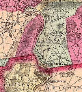
The South Hadley Canal was a canal along the Connecticut River in South Hadley, Massachusetts. It was the earliest navigable canal in the United States, with operation commencing in 1795. It has been listed on the National Register of Historic Places as the South Hadley Canal Historic District.

The Holyoke Canal System is a system of power canals in Holyoke, Massachusetts. It is split into three canals based on elevation and distance from the inlet at the Holyoke Dam- the First Level Canal, Second Level Canal, and Third Level Canal. Constructed over a period between 1847 and 1892, the Canal System, along with the Dam, is recognized as a Historic Mechanical Engineering Landmark by the American Society of Mechanical Engineers for its use in the development of the Venturi meter by Clemens Herschel, the first means of measuring large-scale flows, and the McCormick-Holyoke Turbine by John B. McCormick, which doubled the efficiency of turbines to more than 80% in its time.

The French King Bridge is the three-span "cantilever arch" bridge that crosses the Connecticut River on the border between the towns of Erving and Gill, Massachusetts, United States. The bridge, part of Massachusetts Route 2, carries automobile, bicycle, and pedestrian traffic and is owned and managed by the Massachusetts Department of Transportation (MassDOT).

The Norwottuck Rail Trail Bridge is a former crossing of Boston and Maine Railroad over the Connecticut River in western Massachusetts, connecting the towns of Northampton and Hadley, by the Norwottuck Rail Trail, which is currently used for bicycle and foot traffic.

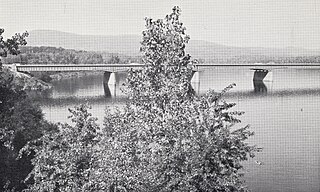
The Hampden County Memorial Bridge is a reinforced-concrete arch bridge that spans the Connecticut River between Springfield, Massachusetts and West Springfield, Massachusetts, constructed in 1922. The bridge is owned by Massachusetts Highway Department and is located on Massachusetts Route 147. It spans 209 feet (64 m) and rises 29.71 feet (9.06 m) above the river.

The Schell Memorial Bridge is a steel cantilever Pennsylvania (Petit) truss bridge spanning the Connecticut River in the town of Northfield, Massachusetts. Designed by Edward S. Shaw, the bridge abutments and piers were built by the firm of Ellis & Buswell of Woburn, Massachusetts, and the superstructure was built by the New England Structural Company of East Everett, Massachusetts. The bridge was commissioned by Francis R. Schell, who gave $42,000 for design and construction. Construction began in 1901 and was completed in 1903. In 1985, due to advanced deterioration of the steel truss members, the bridge was barricaded and abandoned.

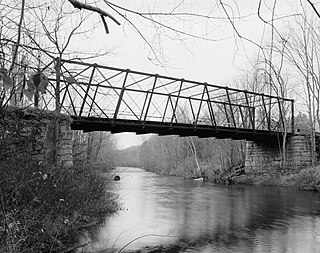
The Bardwell's Ferry Bridge, built in 1882, is an historic lenticular truss bridge spanning the Deerfield River between the towns of Shelburne and Conway in Franklin County, Massachusetts. The bridge is listed on the National Register of Historic Places and is designated as a Massachusetts Historic Civil Engineering Landmark by the American Society of Civil Engineers.

The Atherton Bridge is a historic iron truss bridge in Lancaster, Massachusetts, spanning the South Branch of the Nashua River. It is a rare example of a hybrid pony truss that is similar to the 19th century truss design of Simeon S. Post. It was built by J. H. Cofrode & Co. of Philadelphia in 1870. It was the first iron bridge to be constructed in the town. The bridge was added to the National Register of Historic Places in 1979.
The Ponakin Bridge is a historic Post truss bridge spanning the Nashua River in northern Lancaster, Massachusetts. The bridge was built in 1871, and originally carried the main north–south road, which was bypassed by the construction of Massachusetts Route 70. It is now unsafe and closed even to pedestrians. The bridge, with a design once common but now extremely rare, was listed on the National Register of Historic Places in 1979.
The Joseph E. Muller Bridge is a crossing of the Connecticut River in Western Massachusetts, connecting the communities of Holyoke and South Hadley. The bridge carries U.S. Route 202 (US 202).

The Middlefield–Becket Stone Arch Railroad Bridge District is a historic district extending through parts of the towns of Chester, Middlefield, and Becket, Massachusetts. The district encompasses a 3.7-mile (6.0 km) stretch of railroad right of way in which there are ten bridge crossings, including nine over the west branch of the Westfield River. The bridges were built in four time periods: 1840, 1866, 1912, and 1928. Nine of the ten bridges are stone or concrete masonry work, and one is a truss girder bridge. All are, with only minor exceptions, in excellent and original condition. The bridges were built to carry the Western Railroad through on its run from the Connecticut River to the Hudson River. This section of railroad was the most expensive the company had to build, costing over $1 million in 1840.

Choate Bridge (1764) is a historic stone arch bridge carrying Route 1A/Route 133 over the Ipswich River in Ipswich, Massachusetts. It is one of the oldest surviving bridges in North America, and is probably the oldest in Massachusetts. It was listed on the National Register of Historic Places in 1972 and also has been designated as a National Historic Civil Engineering Landmark.

The Linden Street Bridge is a historic bridge on the abandoned Central Massachusetts Railroad over Linden Street in Waltham, Massachusetts. It is a riveted lattice through truss bridge, built in 1894 by the Pennsylvania Steel Company, and is one of only three such bridges left in the state. The bridge is 98 feet 3 inches (29.95 m) long and 17 feet (5.2 m) wide, with an inside truss height of 21 feet 11.5 inches (6.693 m), and rests on granite abutments. The design of the bridge was based on that of the Northampton crossing of the Connecticut River by the same railroad. The line has been out of service since 1975.

The Bellows Falls Arch Bridge was a three-hinged steel through arch bridge over the Connecticut River between Bellows Falls, Vermont and North Walpole, New Hampshire. It was structurally significant as the longest arch bridge in the United States when it was completed in 1905.

Bridge No. 1132 is an open-spandrel concrete arch bridge carrying the two-lane Connecticut Route 80 across the Hammonasset River, between Killingworth and Madison, Connecticut. Built in 1934, it is one of a small number of open-spandrel concrete bridges in the state, and was noted for its aesthetics at the time of its construction. It was listed on the National Register of Historic Places in 2004.
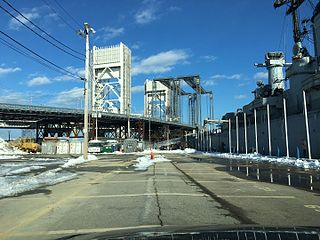
The Fore River Bridge spans the Weymouth Fore River between Quincy and Weymouth, Massachusetts. The total length of the bridge including the approaches is 2,216 feet (675 m).

The Holyoke Dam, also referred to as the Hadley Falls Dam, or Hadley Falls Station is a granite dam built to produce hydroelectric power in tandem with the Holyoke Canal System at Hadley Falls on the Connecticut River, between Holyoke and South Hadley, Massachusetts.


