This article needs additional citations for verification .(November 2016) |


The waterfront area of a city or town is its dockland district, or the area alongside a body of water.
This article needs additional citations for verification .(November 2016) |
The waterfront area of a city or town is its dockland district, or the area alongside a body of water.
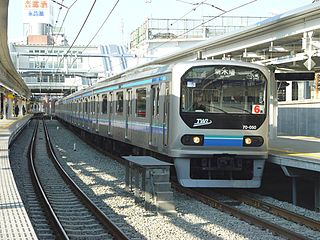
The Rinkai Line is a railway line in Tokyo, Japan. It is the only line operated by the third-sector company Tokyo Waterfront Area Rapid Transit. It connects central Tokyo to the artificial islands of Aomi and Odaiba. The line is served by some trains on the East Japan Railway Company Saikyō Line which continue on to Shinjuku, Ikebukuro, Ōmiya, and Kawagoe.

The Victoria & Alfred (V&A) Waterfront in Cape Town is situated on the Atlantic shore, Table Bay Harbour, the City of Cape Town and Table Mountain. Adrian van der Vyver designed the complex.

Harbourfront is a neighbourhood on the northern shore of Lake Ontario within the downtown core of the city of Toronto, Ontario, Canada. Part of the Toronto waterfront, Harbourfront extends from Bathurst Street in the west, along Queens Quay, with its ill-defined eastern boundary being either Yonge Street or York Street. Its northern boundary is the Gardiner Expressway. Much of the district was former water lots filled in during the early 1900s to create a larger harbour district. After shipping patterns changed and the use of the Toronto harbour declined, the area was converted from industrial uses to a mixed-use district that is mostly residential and leisure.

A stevedore, also called a longshoreman, a docker or a dockworker, is a waterfront manual laborer who is involved in loading and unloading ships, trucks, trains or airplanes.

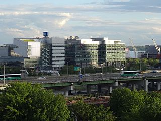
Waterfront is a Washington Metro station in the Southwest Waterfront neighborhood of Washington, D.C., United States. The station was opened on December 28, 1991, and is operated by the Washington Metropolitan Area Transit Authority (WMATA). Waterfront is located in the Southwest Waterfront neighborhood at the intersection of 4th and M Streets SW.

The Toronto waterfront is the lakeshore of Lake Ontario in the city of Toronto, Ontario, Canada. It spans 46 kilometres between the mouth of Etobicoke Creek in the west and the Rouge River in the east.

Southwest is the southwestern quadrant of Washington, D.C., the capital of the United States, and is located south of the National Mall and west of South Capitol Street. It is the smallest quadrant of the city, and contains a small number of named neighborhoods and districts, including Bellevue, Southwest Federal Center, the Southwest Waterfront, Buzzard Point, and the military installation known as Joint Base Anacostia–Bolling.

Governor Tom McCall Waterfront Park is a 36.59-acre (148,100 m2) park located in downtown Portland, Oregon, along the Willamette River. After the 1974 removal of Harbor Drive, a major milestone in the freeway removal movement, the park was opened to the public in 1978. The park covers 13 tax lots and is owned by the City of Portland. The park was renamed in 1984 to honor Tom McCall, the Oregon governor who pledged his support for the beautification of the west bank of the Willamette River—harkening back to the City Beautiful plans at the turn of the century which envisioned parks and greenways along the river. The park is bordered by RiverPlace to the south, the Steel Bridge to the north, Naito Parkway to the west, and Willamette River to the east. In October 2012, Waterfront Park was voted one of America's ten greatest public spaces by the American Planning Association.

Marina Bay is a bay located in the Central Area of Singapore, surrounded by the perimeter of four other planning areas, the Downtown Core, Marina East, Marina South and Straits View. The area surrounding the bay itself, also called Marina Bay, is a 360 hectare extension to the adjacent Central Business District. It is also the new downtown of Singapore, built on reclaimed land.

Canton is a historic waterfront neighborhood in Baltimore, Maryland, United States. The neighborhood is along Baltimore's outer harbor in the southeastern section of the city, roughly two miles east of Baltimore's downtown district and next to or near the neighborhoods of Patterson Park, Fell's Point, Highlandtown, and Brewers Hill.

Sunnyside is a lakefront district in Toronto, Ontario, Canada. It includes a beach and park area along Lake Ontario's Humber Bay, from west of Exhibition Place to the mouth of the Humber River. The area has several recreation uses, including rowing clubs, sports clubs, picnic areas, playgrounds, a nightclub, a bathing pavilion and public pool. The area is a 3 kilometres (1.9 mi) long strip along the lakeshore, bounded by the Gardiner Expressway and rail lines, which separate it from the Parkdale, Roncesvalles and Swansea neighbourhoods to the north. The name originates in a local farm owned by John Howard, which was situated just to the north, on the location of the current St. Joseph's Health Centre hospital.
Ferndale is a suburb of Johannesburg, South Africa. It is located in Region B of the City of Johannesburg Metropolitan Municipality. The area, located in the region of Randburg is very central and has a good mix of residential homes, shops and commercial property. It is very close to Sandton with its main route, Wlliam Nicol, extending to Bryanston and Fourways.
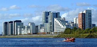
Glasgow Harbour is an urban regeneration scheme at Partick in the West End of the city of Glasgow, Scotland.

The Dubai Waterfront was expected to become the largest waterfront and largest man-made development in the world. The project is a conglomeration of canals and artificial archipelago; it would occupy the last remaining Persian Gulf coastline of Dubai, the most populous emirate of the United Arab Emirates. It was planned to consist of a series of zones with mixed use including commercial, residential, resort, and amenity areas. The vision of the project is "to create a world-class destination for residents, visitors and businesses in the world's fastest growing city".

Downtown Vancouver is the central business district and the city centre neighbourhood of Vancouver, Canada, on the northwestern shore of the Burrard Peninsula in the Lower Mainland region of British Columbia. It occupies most of the north shore of the False Creek inlet, which cuts into the Burrard Peninsula creating the Downtown Peninsula, where the West End neighbourhood and Stanley Park are also located.
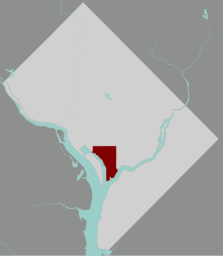
The Southwest Waterfront is a neighborhood in Southwest Washington, D.C. The Southwest quadrant is the smallest of Washington's four quadrants, and the Southwest Waterfront is one of only two residential neighborhoods in the quadrant; the other is Bellevue, which, being east of the Anacostia River, is frequently, if mistakenly, regarded as being in Southeast
East Bayfront, or the East Bayfront Precinct, is an emerging neighbourhood in Toronto, Ontario, Canada. It is currently undergoing a transformation from industrial use to mixed-use as part of Waterfront Toronto's plans to create a residential and commercial district urban core near the lake.
East Bayfront LRT is a proposed Toronto streetcar line that would serve the East Bayfront and Port Lands areas in Toronto, Ontario, Canada. It would run from Union station under Bay Street and along Queens Quay and Cherry Street to a new Villiers Island Loop along Commissioners Street east of Cherry Street. It would complement the existing 509 Harbourfront service which connects Union Station to Queens Quay west of Bay Street. Longer term plans are to extend the East Bayfront line from Cherry and Commissioners Streets to the proposed East Harbour station along the planned Ontario Line.

Belgrade Waterfront, known in Serbian as Belgrade on Water, is an urban renewal development project headed by the Government of Serbia aimed at improving Belgrade's cityscape and economy by revitalizing the Sava amphitheater, a neglected stretch of land on the right bank of the Sava river, between the Belgrade Fair and Branko's bridge. It was started in 2014 with the reconstruction of the Belgrade Cooperative building, which was finished in June of the same year. It is the second largest mixed use complex under construction in Europe, just after Minsk Mir, worth 3.5 billion dollars. Belgrade Waterfront complex will include 7,000 residential units for 14,000 residents, luxury hotels including W Hotel and St. Regis, 2000 offices, the largest shopping mall in southeast Europe, and public buildings within a total construction area of 1.8 million sq.
Sidewalk Toronto is a cancelled urban development project proposed by Sidewalk Labs at Quayside, a waterfront area in Toronto, Ontario, Canada. This project was first initiated by Waterfront Toronto in 2017 by issuing the request for proposal (RFP) on development of the Quayside area. Sidewalk Labs, which is a subsidiary of Google, won the bid in 2017. The Master Innovation Development Plan (MIDP) was created in 2019 through conversations with over 21,000 Torontonians and aimed to be an innovative reinvention of Toronto's neglected eastern downtown waterfront.
![]() Media related to Waterfronts at Wikimedia Commons
Media related to Waterfronts at Wikimedia Commons
| National libraries | |
|---|---|
| Other | |