Cape Upstart is a national park in the locality of Guthalungra in the Whitsunday Region local government area of North Queensland, Australia, 1,016 km northwest of Brisbane.

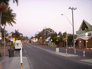
Bowen is a coastal town and locality in the Whitsunday Region on the eastern coast of Queensland, Australia. The town of Merinda and the Abbot Point coal shipping port are also within the locality of Bowen. At the 2016 census, Bowen had a population of 10,377.

Mackay is a city and its centre suburb in the Mackay Region on the eastern or Coral Sea coast of Queensland, Australia. It is located about 970 kilometres (603 mi) north of Brisbane, on the Pioneer River. Mackay is nicknamed the sugar capital of Australia because its region produces more than a third of Australia's sugar. At June 2018 Mackay had a population of 80,148, having decreased slightly at an average annual rate of -0.32% year-on-year over the preceding five years.
Airlie Beach is a coastal locality in the Whitsunday Region of Queensland, Australia. In the 2016 census, Airlie Beach had a population of 1,208 people.

Shute Harbour is a coastal locality and harbour in the Whitsunday Region of Queensland, Australia. In the 2016 census, Shute Harbour had a population of 122 people.

Proserpine is a town and a locality in the Whitsunday Region, Queensland, Australia. Founded in the 1890s, it is the administrative/service centre and gateway to the Whitsunday Region by road, rail and air. At the 2016 census, Proserpine had a population of 3,562. Proserpine is expected to grow rapidly due to its ample land for development, investment in infrastructure and its affordability for first home buyers and families. It is also planned to become an export hub for produce from the northern region which will further boost employment. The town has seen significant public and private investment in recent years and is a popular area for new residents to the region with ex residents of places like Sydney finding Proserpine an attractive town to migrate to, the town currently holds the top ranking for suburbs in the Mackay/Whitsunday region on Homely.com.au when ranked by infrastructure, education, sporting facilities. It is also popular among golfers with the only 18 hole course on the mainland.

The Regions of Queensland refer to the geographic areas of the Australian state of Queensland. Due to its large size and decentralised population, the state is often divided into regions for statistical and administrative purposes. Each region varies somewhat in terms of its economy, population, climate, geography, flora and fauna. Cultural and official perceptions and definitions of the various regions differ somewhat depending on the government agency or popular group by which they are being applied.

Foxdale is a locality in the Whitsunday Region, Queensland, Australia.

Proserpine Airport is located in Gunyarra, Whitsunday Region, Queensland, Australia, 14 kilometres (8.7 mi) south of Proserpine. The airport serves the mainland and offshore islands with flights to Brisbane, Sydney (Tigerair) and Melbourne.

The Shire of Bowen was a local government area in the North Queensland region of Queensland, Australia. The shire, administered from the town of Bowen, covered an area of 21,184.4 square kilometres (8,179.3 sq mi), and existed as a local government entity from 1879 until 2008, when it amalgamated with the Shire of Whitsunday to form the Whitsunday Region.
The Shire of Whitsunday was a local government area located in the North Queensland region of Queensland, Australia. The shire, administered from the town of Proserpine, covered an area of 2,678.3 square kilometres (1,034.1 sq mi), and existed as a local government entity from 1910 until 2008, when it amalgamated with the Shire of Bowen to form the Whitsunday Region.

Whitsunday Airport is an airport located in Flametree in the Whitsunday Region, Queensland, Australia. It is located between the popular tourist destinations of Airlie Beach, Shute Harbour and the Whitsunday Islands. Due to the mountainous terrain in the tourist area, there are limited opportunities for airports.
In South Australia, one of the states of Australia, there are many areas which are commonly known by regional names. Regions are areas that share similar characteristics. These characteristics may be natural such as the Murray River, the coastline, desert or mountains. Alternatively, the characteristics may be cultural, such as common land use. South Australia is divided by numerous sets of regional boundaries, based on different characteristics. In many cases boundaries defined by different agencies are coterminous.
Guthalungra is a town and a coastal locality in the Whitsunday Region, Queensland, Australia.
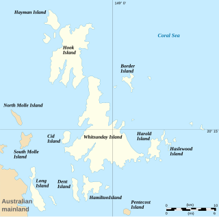
Whitsundays is an island group locality in the Whitsunday Region, Queensland, Australia. It mostly consists of the Whitsunday Group of islands off the Queensland east coast in the Coral Sea, a mix of inhabited and uninhabited islands. In the 2016 census, Whitsundays had a population of 2,269 people.

Mount Rooper is a coastal locality in the Whitsunday Region, Queensland, Australia. In the 2016 census, Mount Rooper had no population.