
Myanmar is the northwesternmost country of mainland Southeast Asia located on the Indochinese peninsula. With an area of 261,228 sq mi, it is the second largest country in Southeast Asia and the largest on mainland Southeast Asia. The kite-shaped country stretches from 10'N to 20'N for 1,275 miles (2,050 km) with a long tail running along the western coast of the Malay Peninsula.

The Bay of Bengal is the northeastern part of the Indian Ocean. Geographically, it is positioned between the Indian subcontinent and the Indochinese peninsula, located below the Bengal region. It is the largest water region called a bay in the world.

The Andaman Sea is a marginal sea of the northeastern Indian Ocean bounded by the coastlines of Myanmar and Thailand along the Gulf of Martaban and west side of the Malay Peninsula, and separated from the Bay of Bengal to its west by the Andaman Islands and the Nicobar Islands. Its southern end is at Breueh Island just north of Sumatra, with the Strait of Malacca further southeast.
Pyuntaza is a small town located in Nyaunglebin Township, Bago District, Bago Region, Myanmar. It is about 70 kilometres (43 mi) from Bago.
Mawlamyine, formerly Moulmein, is the fourth-largest city in Myanmar (Burma), 300 kilometres (190 mi) south east of Yangon and 70 kilometres (43 mi) south of Thaton, at the mouth of Thanlwin (Salween) River. Mawlamyine was an ancient city and the first capital of British Burma. The city is currently the capital and largest city of Mon State and the main trading centre and seaport in south eastern Myanmar.

Bago, formerly known as Hanthawaddy, is a city and the capital of the Bago Region in Myanmar. It is located 91 kilometres (57 mi) north-east of Yangon.
Mottama is a town in the Thaton District of Mon State, Myanmar. Located on the west bank of the Thanlwin river (Salween), on the opposite side of Mawlamyaing, Mottama was the capital of the Martaban Kingdom from 1287 to 1364, and an entrepôt of international repute until the mid-16th century.
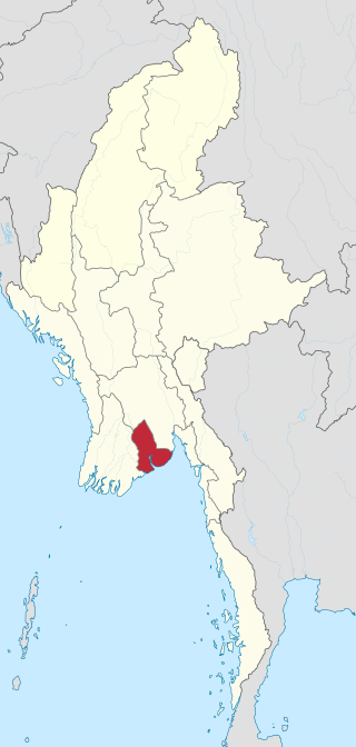
Yangon Region(Burmese: ရန်ကုန်တိုင်းဒေသကြီး; MLCTS: rankun tuing desa. kri:, pronounced [jàɰ̃ɡòʊɰ̃ táɪɰ̃ dèθa̰ dʑí]; formerly Rangoon Division and Yangon Division) is an administrative region of Myanmar. Located in central Myanmar, the division is bordered by Bago Region to the north and east, the Gulf of Martaban to the south, and Ayeyarwady Region to the west. Yangon Region is dominated by its capital city of Yangon, the former national capital and the largest city in the country. Other important cities are Thanlyin and Twante. The division is the most developed region of the country and the main international gateway. The division measures 10,170 km2 (3,930 sq mi).

The Irrawaddy River is a river that flows from north to south through Myanmar (Burma). It is the country's largest river and most important commercial waterway. Originating from the confluence of the N'mai and Mali rivers, it flows relatively straight North-South before emptying through the Irrawaddy Delta in the Ayeyarwady Region into the Andaman Sea. Its drainage basin of about 404,200 square kilometres (156,100 sq mi) covers a large part of Burma. After Rudyard Kipling's poem, it is sometimes referred to as 'The Road to Mandalay'.

Operation Dracula was a World War II-airborne and amphibious attack on Rangoon by British and Anglo-Indian forces during the Burma Campaign.
The Gulf of Martaban or the Gulf of Mottama is an arm of the Andaman Sea in the southern part of Burma. The gulf is named after the port city of Mottama. The Sittaung, Salween and Yangon rivers empty into it.

Thailand has 22 river basins with 254 sub-basins. Rainwater is one of the most important sources of water. Thailand's water resource per capita is less than that of other countries in the region.
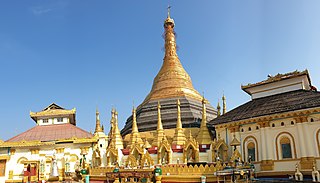
The Great Bell of Dhammazedi was a bronze bell, believed to be the largest bell ever cast. It was cast on 5 February 1484 by order of King Dhammazedi of Hanthawaddy Pegu, and presented to the Shwedagon Pagoda of Dagon.
The Daai are an ethnic group living in Chin State, Myanmar. The Daai consist of 32 Chin tribes, which have been registered by the Government of Burma since 1890. The recent Military Regime’s census mentions the Daai tribe as the 62nd of 135 tribes of Burma. Researchers refer to them as the Daai group in the ethnic survey book of Burma. The Daai Chin appear to be of Mongolian, Indo-Chinese, and Tibeto-Burman descent. The Daai people live in the Mindat, Paletwa, Matupi and Kanpetlet townships of Southern Chin State in Burma. There are more than 180 Daai villages with a total population of somewhere between 40,000 and 50,000. Their population makes the Daai-Chin the majority tribe of the Southern Chin Hills.
Rail transport in Myanmar began in 1877. Three private rail companies were nationalised nineteen years later. During the Japanese occupation of Burma, Allied prisoners of war were forced to build the Burma Railway. Myanmar Railways has expanded its network somewhat since 1988.
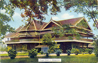
Pegu Club is a recognized heritage site in Yangon, Myanmar, which was a Victorian-style Gentlemen's club founded in 1871 during the British colonization of Burma. The building was built in 1880 and finished in 1882. Pegu Club used to be a place for British officials to spend their time for a drink or two. It was well known because of its signature Pegu Club Cocktail. In southeast Asia, Pegu Club was an equivalent place to the Royal Selangor Club of Kuala Lumpur and The Tanglin Club of Singapore. Rudyard Kipling, as a young newspaperman, visited Pegu Club when he was in Yangon in 1889. Paul Theroux visited Pegu Club in the early 1970s and wrote about it in his book The Great Railway Bazaar. The first phase of the Pegu Club's restoration was completed in 2018.

The Burmese–Siamese War (1759–1760) was the first military conflict between the Konbaung dynasty of Burma (Myanmar) and the Ban Phlu Luang Dynasty of the Ayutthaya Kingdom of Siam. It reignited the centuries-long conflict between the two Southeast Asian states that would last for another century. The Burmese were "on the brink of victory" when they suddenly withdrew from their siege of Ayutthaya because their king Alaungpaya had fallen ill. He died three weeks later, ending the war.
Setse(Burmese: စက်စဲကမ်းခြေ) is a beach resort on the Gulf of Martaban of the Andaman Sea in Thanbyuzayat Township, of Mon State, in southern Myanmar. The beach itself is composed of brown sand, is quite wide and about 5.6 kilometers (3.5 mi) long, but the water is often muddy when currents bring down silt from the Salween river which enters the Gulf of Martaban just to the north. Setse has been a resort since the 19th century, and still remains popular.

Min Razagyi, also known as Salim Shah, was king of Arakan from 1593 to 1612. His early reign marked the continued ascent of the coastal kingdom, which reached full flight in 1599 by defeating its nemesis Toungoo Dynasty, and temporarily controlling the Bay of Bengal coastline from the Sundarbans to the Gulf of Martaban until 1603. But the second half of his reign saw the limits of his power: he lost the Lower Burmese coastline in 1603 and a large part of Bengal coastline in 1609 due to insurrections by Portuguese mercenaries. He died in 1612 while struggling to deal with Portuguese raids on the Arakan coast itself.
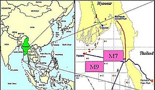
The 1930 Bago (Pegu) earthquake, also known as the Swa earthquake struck Myanmar on 5 May. The moment magnitude (Mw ) 7.4 earthquake had a focal depth of 35 km (22 mi) and maximum Rossi–Forel intensity of IX. The earthquake was the result of rupture along a 131 km (81 mi) segment of the Sagaing Fault—a major strike-slip fault that runs through the country. Extensive damage was reported in the southern part of the country, particularly in Bago and Yangon, where buildings collapsed and fires erupted. At least 550, and possibly up to 7,000 people were killed. A moderate tsunami was generated along the Burmese coast which caused minor damage to ships and a port. It was felt for over 570,000 km2 (220,000 sq mi) and as far as Shan State and Thailand. The mainshock was followed by many aftershocks; several were damaging; additional earthquakes occurred in July and December, killing dozens. The December earthquake was similarly-sized which also occurred along the Sagaing Fault.
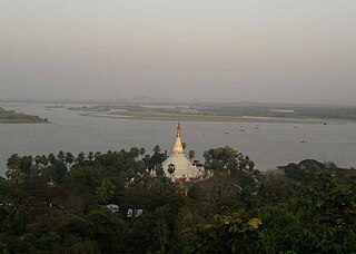
Yangon River, also called Rangoon River, marine estuary in southern Myanmar (Burma), formed at the city of Yangon (Rangoon) by the confluence of the Pegu and Myitmaka rivers. It empties into the Gulf of Martaban of the Andaman Sea, 25 miles (40 km) southeast. Yangon River is about 40 km long. It flows past Thanlyin and Pokataloke.

