
The Rhine is one of the major European rivers. The river begins in the Swiss canton of Graubünden in the southeastern Swiss Alps. It forms part of the Swiss-Liechtenstein, Swiss-Austrian, and Swiss-German borders. After that the Rhine defines much of the Franco-German border, after which it flows in a mostly northerly direction through the German Rhineland. Finally in Germany, the Rhine turns into a predominantly westerly direction and flows into the Netherlands where it eventually empties into the North Sea. It drains an area of 9,973 km2 and its name derives from the Celtic Rēnos. There are also two German states named after the river, North Rhine-Westphalia and Rhineland-Palatinate.

Overijssel is a province of the Netherlands located in the eastern part of the country. The province's name translates to "across the IJssel", from the perspective of the Episcopal principality of Utrecht by which it was held until 1528. The capital city of Overijssel is Zwolle and the largest city is Enschede. The province had a population of about 1,184,000 as of January 2023. The land mostly consists of grasslands and some forests ; it also borders a small part of the IJsselmeer to the west.

Zwolle is a city and municipality in the Northeastern Netherlands. It is the capital of the province of Overijssel and the province's second-largest municipality, after Enschede, and has a population of 132.441 as of December 2023. Zwolle borders the province of Gelderland and lies on the eastern side of the River IJssel.

The IJssel is a Dutch distributary of the river Rhine that flows northward and ultimately discharges into the IJsselmeer, a North Sea natural harbour. It more immediately flows into the east-south channel around the Flevopolder, Flevoland which is kept at 3 metres below sea level. This body of water is then pumped up into the IJsselmeer.

Olst-Wijhe is a municipality in the province of Overijssel, eastern Netherlands. It borders the Overijssel municipalities of Zwolle to the north, Raalte to the north and east and Deventer to the south; and the Gelderland municipalities of Voorst, Epe and Heerde to the west.

Zwartewaterland is a municipality in the province Overijssel in the eastern Netherlands.

Nederrijn is the Dutch part of the Rhine from the confluence at the town of Angeren of the cut-off Rhine bend of Oude Rijn (Gelderland) and the Pannerdens Kanaal. The city of Arnhem lies on the right (north) bank of the Nederrijn, just past the point where the IJssel branches off. The Nederrijn flows on to the city of Wijk bij Duurstede, from where it continues as the Lek. The once-important but now small Kromme Rijn branch carries the name "Rhine" towards the city of Utrecht.

The Vechte in German and in Low Saxon or Vecht in Dutch, often called Overijsselse Vecht in the Netherlands to avoid confusion with its Utrecht counterpart, is a river in Germany and the Netherlands. Its total length is 182 km (113 mi), of which 107 km (66 mi) are on German soil.

The Vecht is a Rhine branch in the Dutch province of Utrecht. It is sometimes called Utrechtse Vecht to avoid confusion with its Overijssel counterpart. The area along the river is called the Vechtstreek.
The Vidrus fluvius, Greek Ouidros potamos, is a river of Ptolemy's Geographia (2.11) located in Germania. Its exact location is not known for certain, but it must be in the low countries.
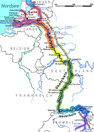
The Lower Rhine flows from Bonn, Germany, to the North Sea at Hook of Holland, Netherlands ; alternatively, Lower Rhine may refer to the part upstream of Pannerdens Kop, excluding the Nederrijn.

Salland is a historical dominion in the west and north of the present Dutch province of Overijssel. Nowadays Salland is usually used to indicate a region corresponding to the part of the former dominion more or less to the west of Twente.

River bifurcation occurs when a river flowing in a single channel separates into two or more separate streams which then continue downstream. Some rivers form complex networks of distributaries, typically in their deltas. If the streams eventually merge again or empty into the same body of water, then the bifurcation forms a river island.
The Vechtstreek is a region in the Dutch provinces of Utrecht and North Holland along the Vecht River between the towns of Utrecht and Amsterdam. Located in the economic heartland of the Netherlands, it is known for its natural environment and history. The Vechtstreek is known for its many vestiges of the Dutch Golden Age, including castles, homes, parks and tea houses. They bear witness to the greatness and wealth of that period, the important commercial role played by the Vecht River and the area's history as a residential area for the nobility and wealthy.

The Rhine–Meuse–Scheldt delta is a river delta in the Netherlands formed by the confluence of the Rhine, the Meuse and the Scheldt rivers. In some cases, the Scheldt delta is considered a separate delta to the Rhine–Meuse delta. The result is a multitude of islands, branches and branch names, in which a waterway that appears to be one continuous stream may have numerous separate names for different sections, e.g. Rhine → Bijlands Kanaal → Pannerdens Kanaal → Nederrijn → Lek → Nieuwe Maas → Het Scheur → Nieuwe Waterweg. Since the Rhine contributes most of the water, the term "Rhine Delta" is commonly used, although this name is also used for the delta where the Alpine Rhine flows into Lake Constance. By some calculations, the Rhine–Meuse–Scheldt delta covers 25,347 km2 (9,787 sq mi), making it the largest in Europe.

The Ketelmeer is the tongue of the IJsselmeer into which the River IJssel drains, it is situated between the polders Noordoostpolder and Oostelijk Flevoland, and connects the river IJssel to the IJsselmeer. It is one of the bordering lakes, a continuous body of water which separate Flevoland from the Noordostpolder and the ancient lands of the provinces of Gelderland and Utrecht. The Ketelmeer covers an area of 3500 hectares, most of which is in the province of Flevoland, but the river delta of the IJssel is in province of Overijssel.

