2002 Bou'in-Zahra earthquake

Last updated

2002 Bou'in–Zahra earthquake
Iran relief location map.jpg
Green pog.svg
Tehran
Green pog.svg
Hamedan
Green pog.svg
Baghdad
Bullseye1.png
UTC  time2002-06-22 02:58:21
ISC  event 3187856
USGS-ANSS ComCat
Local date22 June 2002
Local time7:28 a.m. IST [1]
Duration7 seconds [2]
Magnitude6.5 Mwc [3]
Depth10 km (6.2 mi) [4]
Epicenter 35°37′N49°02′E / 35.62°N 49.04°E / 35.62; 49.04 [4]
Type Thrust
Areas affected Iran
Max. intensity VIII (Severe) [5]
Landslides59 [6]
Aftershocksmore than 20 [1]
Casualtiesat least 230 dead, [4] 1,500 injured, [1] and 50,000 homeless [2]

The 2002 Bou'in-Zahra earthquake (also known as the 2002 Avaj earthquake or the 2002 Changureh earthquake [a] ) occurred on 22 June 2002. The epicenter was near the city [b] of Bou'in-Zahra [c] in Qazvin Province, a region of northwestern Iran which is crossed by several major faults that is known for destructive earthquakes. The shock measured 6.5 on the Mwc scale, [7] had a maximum Mercalli intensity of VIII (Severe), and was followed by more than 20 aftershocks. At least 230 people were killed and 1,500 more were injured.

Contents

According to the International Institute of Earthquake Engineering and Seismology (IIEES), the earthquake was felt as far away as the capital city of Tehran, approximately 290 kilometres (180 mi) east of the epicenter, although no damage was reported there. Most houses in the region were single-story masonry buildings, and virtually all of these collapsed. The public became angry due to the slow official response to victims who needed supplies. Residents of the town of Avaj resorted to throwing stones at the car of a government minister. [8]

Background and tectonics

The northeastern part of Iran lies across part of the belt of active continental collision between the Arabian Plate and the Eurasian Plate. [6] Iran is crossed by several major faults, with 90% of them being seismically active and subject to many earthquakes each year; the area around the rupture experiences minor quakes almost daily. [8] [9] [10] The most seismically active parts of this area are the Zagros fold and thrust belt and the Alborz mountain range. [6] Qazvin Province, which is located between these two zones, suffers less earthquakes, but these may be more powerful because stresses have longer to build. [8]

The Bou'in-Zahra earthquake was located in an area of active thrust faulting and folding, parallel and south of the southern edge of the Alborz mountain range, [11] and was the 11th rupture in the previous two months in central Iran. [10] A seismic inversion of long-period P and SH body-wave seismograms indicated a rupture on a thrust fault that dips 49 degrees to the southwest and had a centroid depth of roughly 10 kilometres (6 mi). [11] The rupture's mechanism of faulting was reverse. [12] [13]

Multiple-event relocation of the main shock and aftershock epicenters and discontinuous surface ruptures recorded after the earthquake are compatible with northeastward movement on a southwest-dipping thrust, although maximum recorded displacements were less than would have been expected from the observed magnitude. This suggests that most of the slip did not actually reach the Earth's surface but caused folding at the surface. [11] A previously unmapped thrust with little surface expression, the Abdareh fault, has been identified from the disruption of earlier drainage systems by the growth of the fold in its hanging wall, and is thought to be responsible for the earthquake. [10] [11] Such structures are known as blind thrusts, and have been responsible for many destructive earthquakes in Iran and elsewhere. The geomorphological effects of this particular fold have been partly obscured by the presence of an earlier Neogene topography. [11] The Qazvin region was hit by an even greater earthquake in 1962, which killed 12,200. [14] In 1990 a rupture killed over 40,000 people, injured 60,000, and left more than 500,000 homeless. [15]

Damage and casualties

The Kharaghan twin towers before the earthquake Kharaghan.jpg
The Kharāghān twin towers before the earthquake

The earthquake occurred at 02:58  UTC (7:28 a.m. Iran Standard Time), [4] [10] while many of the estimated 60 million Iranians affected [16] were in their homes. [9] Its duration was seven seconds, [2] and the epicenter was near the settlement of Bou'in-Zahra [17] in the Khar river valley, [11] a mountainous farming region [15] about 60 kilometres (37 mi) from the provincial capital of Qazvin. [18] The greatest damage was across an area best known for its seedless grape harvesting, a getaway for wealthy residents of Tehran. [15] At least 230 people were killed, 1,500 injured, and 25,000 left homeless. [1] An earlier death toll was reported as 500, but this number was believed to be inflated once it became known that some of the severely injured had been mistaken for dead. [8] Most of the dead were women, children and the elderly, [19] as many of the men were working in local vineyards. [20] Over 20 aftershocks were recorded, [1] with magnitudes up to 5.1 on the moment magnitude scale. [11] At least three of these caused further casualties and damage, [21] most of which were within a 25 kilometres (16 mi) radius of the main shock. [22]

An estimated 5,000 buildings were damaged beyond repair. [15] In the Qazvin province, 120 buildings were demolished and 50 villages suffered massive damage. In the neighboring Hamadan province, 45 villages were destroyed. [10] A large majority of houses in the region were single-story masonry buildings, and virtually all of these collapsed. [23] As non-engineered structures, these could not withstand seismic forces, with structural failure and collapse resulting from wall-to-wall separation and the lack of structural integrity and of a proper lateral system of resisting. [24] Newer structures built in accordance with the Iranian code of practice for seismic-resistant design fared much better. [23] Damage to the historic Kharaqan tomb towers, which were in a good state of preservation before the event, suggests that the earthquake was possibly one of the most powerful in the region for approximately 900 years. [11]

At a station 28 kilometres (17 mi) from the epicenter, the maximum horizontal and vertical accelerations were recorded to be roughly 0.5  g and 0.26 g. [23] A bridge collapsed as a result of the disaster. [10] Water and irrigation systems were severely damaged near the epicenter, [4] and water facilities were demolished in nine villages. [10] Many of the main water pipelines in the affected areas were damaged or destroyed, causing inadequacies in water availability and quality. [16] Surface cracks were observed in Ab Darreh and Changureh, the villages that suffered the heaviest damage, [4] being roughly 25 kilometres (16 mi) from the epicenter. [11]

The relatively low levels of damage in the towns of Avaj or Ab-e-Garm in comparison to Changureh and Ab Darreh suggest a focus of damage to the northwest of the epicenter due to northwest propagation. [11] In Changureh, only two buildings were left standing and over 120 casualties occurred. Ab Darreh also fared poorly; the disaster destroyed the town's only mosque, toppled 40 homes and killed at least 20 people. [17] North of Avaj, in the village of Esmailabad, survivors recovered 38 corpses, a ninth of the total population, while searching for the missing, feared trapped in the ruins. [20] In another village in the vicinity, Aliabad, two shepherds were the only known survivors. In the small village of Kisse-Jin, roughly 80 corpses were recovered following the rupture. [15] Survivors crying and beating their heads and faces over loved ones were a common sight on Iranian state television. [20]

The cost of the damage was estimated at US$91 million. [4] [d] The quake was felt across a wide area, including the provinces of Qazvin, Gilan, Kurdistan, Zanjan, and Hamedan. [1] Of all these, Qazvin was the most heavily damaged, with an unnamed Qazvin official reporting that 177 had died in the province. [15] It was also felt in the capital of Tehran, roughly 290 kilometres (180 mi) east of the epicenter, [10] although no serious damage was reported. [17] However, Iranian journalist Borzou Daragahi reported that in Tehran he saw buildings sway and glass objects shatter. [15]

Landslides

The Bou'in-Zahra earthquake triggered 59 landslides over an area of about 3,600 square kilometres (1,390 sq mi). Landslides formed due to the quake included 47 falls and topples, nine slides, and three lateral spreads. The largest of these slides was a rockslide, 150 × 100 m (490 × 330 ft), which occurred southeast of Changureh. Landslides triggered by the quake occurred more often in the geologic areas most susceptible to damage, where there were many landslides before. [6]

Relief efforts and aftermath

The Red Crescent Society sent relief workers, detection dogs, 100 tons of food, [16] 1,000 tents, 2,500 blankets, and mobile kitchens to the earthquake-stricken area. In addition, the Iranian army supplied soldiers, machinery and water trucks. [1] To prevent the spread of disease, villages were sprayed with disinfectants and their inhabitants were given tetanus shots, among other measures. [1] After Iranian officials launched an appeal for assistance, [18] the United Nations Development Programme supplied $50,000. [25] The United Nations' Office for the Coordination of Humanitarian Affairs (OCHA) mobilised a United Nations Disaster Assessment and Coordination (UNDAC) team, deploying five members. [26] Pope John Paul II prayed for the earthquake victims and asked for a "generous" response. [17]

United States President George W. Bush offered aid to Iran, which he had previously called part of an "axis of evil". According to him, "human suffering knows no political boundaries" and he stood "ready to assist the people of Iran as needed and as desired". However, the Iranian government refused his help, though it called for the help of non-governmental agencies. [8]

According to Hossein Rahnema, head of the Red Crescent in Changureh, the society "levelled an area to put up tents but most people wanted to stay next to their houses to look after their property". [1] Survivors instead lit small fires amongst the rubble to protect against freezing temperatures. [17] The Iranian President at the time, Mohammad Khatami, declared three days of mourning and visited earthquake-stricken areas on June 25. [27] Hospitals struggled to cope with the surplus of patients, discharging non-critical ones from their wards. [28] The Associated Press stated that 20 funerals were held on June 23, 2002, at a cemetery overlooking the village of Abdareh. [14] A bank account was started to handle public donations for the families of the dead. [19]

Often armed with no more than shovels and spades, soldiers and civilians dug for bodies in the rubble. Other than this, rescue workers were faced with a number of obstacles, including the temperatures of the villages damaged. They were warm during the day, although the villages grew colder at night, making rescue work harder and threatening the health of the homeless and anyone alive and trapped under the debris. Many civilians were discouraged from helping due to fear of aftershocks. According to Gary Oshea of International Rescue, the volunteers did not have enough technical equipment, and the religious leaders seemed unwilling to contribute much. [15] Official rescue work ended on June 24, 2002, when rescue workers said there were no more survivors. [1]

Public reaction

Of the roughly 80 villages that suffered heavy damage, the Iranian government claimed that relief work was mostly complete. [14] Residents of Changureh, however, complained that tents, food, and medicine had not reached them, after waiting in near-freezing temperatures. [1] A man from Avaj stated that only locals helped uncover the body of his child. [29] In protest at Iran's slow response to the tragedy, some 300 people blocked the main road through Avaj. [30] On June 23, "dozens" of Avaj residents threw stones at Interior Minister Abdolvahed Mousavi-Lari's car in anger at the government's delay in providing relief. [19] They also claimed that the death toll was higher than official reports said it was. [8]

Reconstruction

Electricity was restored to affected areas by June 25. [9] On November 9, 2002, the World Bank granted $225 million towards the reconstruction and economic rehabilitation of the area devastated by the quake. [31] Reconstruction of housing and infrastructure by provincial authorities was interrupted for almost four months (November 2002 – February 2003) due to harsh weather conditions. In August 2003, the reconstruction was completed in all villages affected by the earthquake. [16]

See also

Notes

Related Research Articles

<span class="mw-page-title-main">Earthquake</span> Sudden movement of the Earths crust

An earthquake – also called a quake, tremor, or temblor – is the shaking of the surface of Earth resulting from a sudden release of energy in the lithosphere that creates seismic waves. Earthquakes can range in intensity, from those that are so weak that they cannot be felt, to those violent enough to propel objects and people into the air, damage critical infrastructure, and wreak destruction across entire cities. The seismic activity of an area is the frequency, type, and size of earthquakes experienced over a particular time. The seismicity at a particular location in the Earth is the average rate of seismic energy release per unit volume. The word tremor is also used for non-earthquake seismic rumbling.

<span class="mw-page-title-main">2005 Qeshm earthquake</span> Earthquake in Iran

An earthquake occurred on November 27, 2005, at 13:52 IRST on the sparsely populated Qeshm Island off Southern Iran, killing 13 people and devastating 13 villages. It was Iran's second major earthquake of 2005, following the one at Zarand in February. The epicenter was about 1,500 kilometers (930 mi) south of Tehran, close to Iran's southern borders. Initial measurements showed that the earthquake registered about 6.0 on the moment magnitude scale, although that was reduced to 5.8 after further analysis. More than 400 minor aftershocks followed the main quake, 36 of which were greater than magnitude 2.5. The earthquake occurred in a remote area during the middle of the day, limiting the number of fatalities. Iranian relief efforts were effective and largely adequate, leading the country to decline offers of support from other nations and UNICEF.

The 1999 Hector Mine earthquake occurred in Southern California, United States, on October 16 at 02:46:50 PDT. Its moment magnitude was 7.1 and the earthquake was preceded by 12 foreshocks, the largest of which had a magnitude of 3.8. The event is thought to have been triggered by the 1992 Landers earthquake which occurred seven years earlier. It also deformed nearby faults vertically and horizontally. The earthquake's hypocenter was at a depth of 20 kilometers and its epicenter at 34.603° N 116.265° W.

<span class="mw-page-title-main">2004 Al Hoceima earthquake</span> Earthquake near the northern Moroccan coast

The 2004 Al Hoceima earthquake occurred on 24 February at 02:27:47 local time near the coast of northern Morocco. The strike-slip earthquake measured 6.3 on the moment magnitude scale and had a maximum perceived intensity of IX (Violent) on the Mercalli intensity scale. Between 628 and 631 people were killed, 926 were injured, and up to 15,000 people were made homeless in the Al Hoceima-Imzourene-Beni Abdallah area.

Avaj is a city in, and the capital of, the Central District of Avaj County, Qazvin province, Iran, and serves as capital of the county.

<span class="mw-page-title-main">2002 Denali earthquake</span> 7.9 magnitude; November 3, 2002

The 2002 Denali earthquake occurred at 22:12:41 UTC November 3 with an epicenter 66 km ESE of Denali National Park, Alaska, United States. This 7.9 Mw earthquake was the largest recorded in the United States in 37 years. The shock was the strongest ever recorded in the interior of Alaska. Due to the remote location, there were no fatalities and only one injury.

The 1970 Tonghai earthquake occurred at 01:00:41 local time on January 5 with a moment magnitude of 7.1 and a maximum Mercalli intensity of X (Extreme). The strike-slip rupture originated on the Red River Fault, which had not experienced an earthquake above magnitude 7 since 1700, and affected Tonghai County, Yunnan province, China. At least 10,000 people were killed, making it one of the deadliest in its decade. The tremor caused between US$5 and $25 million in damage, felt over an area of 8,781 km2 (3,390 sq mi). In Hanoi, North Vietnam, almost 483 km (300 mi) from the epicenter, victims left their homes as the rupture rumbled through the city.

The 1962 Buin Zahra earthquake occurred on September 1 in the area of Buin Zahra, Qazvin Province, Iran. The shock had a Richter magnitude of 7.1 and resulted in 12,225 fatalities. Qazvin Province lies in an area of Iran that experiences large earthquakes. The 1962 event originated on one of many faults in the area, called the Ipak Fault. The fault is believed to have been reactivated multiple times.

<span class="mw-page-title-main">2013 Bushehr earthquake</span> 6.3 magnitude earthquake in Iran

The 2013 Bushehr earthquake occurred with a moment magnitude of 6.3 on April 9 in Iran. The shock's epicenter was in the province of Bushehr, near the city of Khvormuj and the towns of Kaki and Shonbeh. At least 37 people were killed, mostly from the town of Shonbeh and villages of Shonbeh-Tasuj district, and an estimated 850 people were injured.

The 1992 Murindó earthquake occurred on October 18 at 15:11 UTC with an epicenter in the Department of Chocó, northern Colombia. The shallow magnitude 7.2 earthquake struck northwest of the town of Murindó, killing ten and injured more than a hundred. Thirty-three municipalities were severely damaged.

The 1987 Superstition Hills and Elmore Ranch earthquakes were a pair of earthquakes measuring Mw  6.0 and 6.5 that rattled the Imperial Valley of California. The earthquakes caused damage in Southern California and Mexico, but was limited due to their location in a sparsely populated area. It was felt as far as Las Vegas and Phoenix. More than 90 were injured, and two people were killed in Mexico.

<span class="mw-page-title-main">1812 Ventura earthquake</span> Magnitude 7.1 earthquake in Alta California

The 1812 Ventura earthquake occurred on the morning of December 21 at 11:00 Pacific Standard Time (PST). The 7.1–7.5 magnitude earthquake, with a Modified Mercalli intensity scale rating of X (Extreme), along with its resulting tsunami, caused considerable damage to present-day Santa Barbara and Ventura County, California, which was at the time a territory of the Spanish Empire. One person was killed as a result of the earthquake while another from the aftershock. The earthquake occurred just as the region was recovering from another event on 8 December the same year. Both events are thought to have been related.

The 1902 Turkestan earthquake devastated Xinjiang, China, near the Kyrgyzstan border. It occurred on August 22, 1902, at 03:00:22 with an epicenter in the Tien Shan mountains. The thrust earthquake measured 7.7 on the moment magnitude scale (Mw ) and had a depth of 18 km (11 mi).

The 1995 Menglian earthquake or 1995 Myanmar–China earthquake occurred on 12 July at 05:46:43 local time in the Myanmar–China border region. The earthquake had an epicenter on the Myanmar side of the border, located in the mountainous region of Shan State. It registered 7.3 on the Chinese surface wave magnitude scale (Ms ) and 6.8 on the moment magnitude scale (Mw ). With a maximum Mercalli intensity assigned at VIII, the quake killed eleven people and left another 136 injured. Over 100,000 homes in both countries were destroyed and 42,000 seriously damaged. Some damage to structures were also reported in Chiang Mai and Chiang Rai, Thailand. The low death toll from this earthquake was attributed to an early warning issued prior to it happening. Precursor events including foreshocks and some seismic anomalies led to an evacuation of the area before the mainshock struck. It is thought to be one of the few successfully predicted earthquakes in history.

The 1979 Ghaenat earthquakes were a series of large earthquakes in Qaen County, Khorasan Province, northeast Iran, near the Afghanistan border. The first mainshock, known as the Korizan earthquake with a surface wave magnitude (Ms ) of 6.6 and moment magnitude (Mw ) of 6.8, struck on November 14, while the Ms  7.1 or Mw  7.2 Koli-Boniabad earthquake struck on November 27. The two mainshocks were assigned a maximum Modified Mercalli intensity of VIII (Severe) and X (Extreme), respectively. The earthquakes caused extensive damage throughout northeastern Iran, killing an estimated 297 to 440 people and left at least 279 injured.

The 1997 Bojnurd earthquake occurred on 4 February at 14:07 IRST in Iran. The epicenter of the Mw 6.5 earthquake was in the Kopet Dag mountains of North Khorasan, near the Iran–Turkmenistan border, about 579 km (360 mi) northeast of Tehran. The earthquake is characterized by shallow strike-slip faulting in a zone of active faults. Seismic activity is present as the Kopet Dag is actively accommodating tectonics through faulting. The earthquake left 88 dead, 1,948 injured, and affected 173 villages, including four which were destroyed. Damage also occurred in Shirvan and Bojnord counties. The total cost of damage was estimated to be over US$ 30 million.

<span class="mw-page-title-main">1641 Tabriz earthquake</span> Earthquake centered in northwestern Iran

The 1641 Tabriz earthquake occurred on the night of February 5 in present-day East Azerbaijan province, Iran. The earthquake had an estimated surface-wave magnitude of 6.8 and an epicenter between Lake Urmia and the city of Tabriz. It was one of the most destructive earthquakes in the region, resulting in the loss of up to 30,000 lives.

The 1977 Bob–Tangol earthquake struck Kerman province of Iran on December 20, 1977 at 03:04 Iran Standard Time. The earthquake measured Mw 5.9 and struck at a depth of 22.7 km (14.1 mi). A maximum Modified Mercalli intensity of VII was evaluated based on damage. It had a strike-slip focal mechanism, which was unusual as the source structure was a thrust fault. It was part of a sequence of strong earthquakes along the 400 km (250 mi) Kuh Banan Fault. Between 584 and 665 people perished while a further 500–1,000 were injured; thousands were also made homeless. Casualties from the earthquake was considered moderate due to the sparsely populated area it affected. Preceded by foreshocks the month before, many residents became wary of a larger earthquake and took refuge outside their homes, contributing to the moderate death toll. However, there were none immediately before the mainshock so many were still in their homes when it struck. Aftershocks were felt for several months, some causing additional damage.

<span class="mw-page-title-main">1988 Tennant Creek earthquakes</span> Sequence of strong quakes in Northern Territory

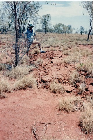
On 22 January 1988, a sequence of destructive earthquakes measuring 6.2, 6.3, and 6.6 struck southwest of Tennant Creek, Australia which was felt as far north as Darwin and in other regions of the country. The largest event of the sequence was the largest earthquake ever recorded in mainland Australia since records began in 1800. An intensity of IX (Violent) was observed. Despite the large magnitude of the earthquakes and a close proximity to a town, in a country where earthquakes of this size are not common, damages were limited. Thousands of aftershocks were reported and felt across Northern Territory.

The 1957 Farsinaj earthquake struck Hamadan, Iran on 13 December at 05:15 local time. The moment magnitude 6.5 earthquake destroyed 211 villages, killed approximately 1,130 people, and left another 900 injured.

References

  1. 1 2 3 4 5 6 7 8 9 10 11 "'No more survivors' in Iran quake". BBC News. 24 June 2002. Retrieved 18 June 2008.
  2. 1 2 3 4 5 Zare, Mehdi (September 2002). "A Seismological Overview on the Changureh (Avaj, Iran) Earthquake of 22 June 2002, Mw=6.3" (PDF). Observatories and Research Facilities for European Seismology. 4 (2). Archived from the original (PDF) on 4 March 2016. Retrieved 2 July 2008.
  3. ANSS. "Iran 2002: M 6.5 - western Iran". Comprehensive Catalog. U.S. Geological Survey. Retrieved 29 March 2018.
  4. 1 2 3 4 5 6 7 "Magnitude 6.5 Western Iran". United States Geological Survey. 13 November 2003. Archived from the original on 18 July 2008. Retrieved 18 June 2008.
  5. Berberian, M. (2014), Earthquakes and Coseismic Surface Faulting on the Iranian Plateau, Developments in Earth Surface Processes (1st ed.), Elsevier, p. 619, ISBN   978-0444632920
  6. 1 2 3 4 Mahdavifar, Mohammad R.; Solaymani, Shahryar; Jafari, Mohammad K. (20 February 2006). "Landslides triggered by the Avaj, Iran earthquake of June 22, 2002". Engineering Geology. 86 (2–3): 166. Bibcode:2006EngGe..86..166M. doi:10.1016/j.enggeo.2006.02.016.
  7. ANSS: Iran 2002 (accessed 2018-03-29).
  8. 1 2 3 4 5 6 "Help too late, say quake survivors". CNN. 24 June 2002. Retrieved 19 June 2008.
  9. 1 2 3 "245 Confirmed Dead In Iran Quake". CBS News . 24 June 2002. Retrieved 19 June 2008.
  10. 1 2 3 4 5 6 7 8 9 "Preliminary Earthquake Reconnaissance Report on the June 22, 2002 Changureh (Avaj), Iran Earthquake". International Institute of Earthquake Engineering and Seismology. 19 July 2002. Archived from the original on 25 March 2010. Retrieved 26 June 2008.
  11. 1 2 3 4 5 6 7 8 9 10 11 12 Walker, R. T.; Bergman, E; Jackson, J; Ghorashi, M; Talebain, M. (2005). "The 2002 June 22 Changureh (Avaj) earthquake in Qazvin province, northwest Iran: epicentral relocation, source parameters, surface deformation and geomorphology". Geophysical Journal International. 160 (2): 707–720. Bibcode:2005GeoJI.160..707W. doi: 10.1111/j.1365-246X.2005.02516.x .
  12. KhalilAllah, Fenghi; Shahryar, Solaymani (2003). "Geometry of Fault Ruptures of the Avaj Region Earthquake". Research Bulletin of Seismology and Earthquake Engineering. 5 (4).
  13. KhalilAllah, Fenghi; Shahryar, Solaymani (2003). "Seismotectonics and Neotectonics of Changureh Earthquake on June 22, 2002". International Institute of Earthquake Engineering and Seismology.
  14. 1 2 3 "Iranians angry at 'slow' quake help". BBC News. 23 June 2002. Retrieved 18 June 2008.
  15. 1 2 3 4 5 6 7 8 9 Slackman, Michael (23 June 2002). "500 Killed, Thousands Injured in Iran Quake". Los Angeles Times . pp. A1. Retrieved 22 August 2008.
  16. 1 2 3 4 "Iran: Earthquake in the Qazvin/Hamadan and Zanjan regions Appeal No. 17/02 Final Report". International Federation of Red Cross And Red Crescent Societies . ReliefWeb. 19 February 2004. Archived from the original on 7 May 2006. Retrieved 20 June 2008.
  17. 1 2 3 4 5 6 7 "Iran buries dead after earthquake". USA Today . Associated Press. 23 June 2002. Retrieved 20 June 2008.
  18. 1 2 "Al menos 500 muertos y 2.000 heridos por un terremoto en Irán". El País (in Spanish). 23 June 2002. Retrieved 23 August 2008.
  19. 1 2 3 "Rescue Teams Continue to Dig in Iran Earthquake Rubble". Voice of America News. 24 June 2002. Archived from the original on 22 May 2011. Retrieved 18 June 2008.
  20. 1 2 3 "222 Dead In Iran Earthquake". CBS News . 23 June 2002. Retrieved 2 July 2008.
  21. Fathi, Nazila (23 June 2002). "Quake in Northern Iran Kills at Least 500". The New York Times . Retrieved 20 June 2008.
  22. Hosseini, S.; Suzuki, S.; Fuji, Y.; Sadeghi, H.; Fatemi Aghda, S. (December 2002). "Aftershock Observation of the 22 June 2002 Changoureh-Avaj Earthquake (Mw 6.5), NW Iran". AGU Fall Meeting Abstracts. 71: 1091. Bibcode:2002AGUFM.S71B1091H.
  23. 1 2 3 Ramazi, Hamidreza; Haghani, Reza (November 2006). "The 22 June 2002 Avaj, Iran, Earthquake: A Field Report". Seismological Research Letters. 77 (6): 723–730. Bibcode:2006SeiRL..77..723R. doi:10.1785/gssrl.77.6.723 . Retrieved 20 June 2008.
  24. Eshghi, Sassan; Zahre, Mehdi; Mahdavifar, Mohammad R (23 June 2002). "The Changureh (Avaj) earthquake of June 22, 2002". Japan Society for Natural Disaster Science. Archived from the original on 18 August 2007. Retrieved 24 August 2008.
  25. "UN assessment team in Iran quake regions says 2,000–4,000 injured. ReliefWeb". Archived from the original on 25 February 2014. Retrieved 20 February 2014.
  26. "Relief efforts continue after Saturday's quake". IRIN . 24 June 2002. Archived from the original on 25 July 2002. Retrieved 30 March 2012.
  27. "Iranians angry at 'slow' quake help". BBC News. 23 June 2002. Retrieved 21 August 2008.
  28. Hill, Amelia (23 June 2002). "Iranian villages razed as quake kills 400". The Observer . Retrieved 24 August 2008.
  29. Hafesi, Parisa (24 June 2002). "Hundreds killed in Iran earthquake". The Guardian . Reuters. Retrieved 20 June 2008.
  30. "Stones thrown at quake officials". One News. 24 June 2002. Retrieved 24 August 2008.
  31. "World Bank grants 225 million dollars for Iran's quake-hit areas". Xinhua News Agency. 9 November 2002. Archived from the original on 12 December 2012. Retrieved 20 June 2008.
  32. "500 dead in Iranian earthquake". The Telegraph . 22 June 2002. Retrieved 22 August 2008.
  33. "Earthquake Kills 500, Injures 2,000 In Iran. Sun Sentinel". Archived from the original on 26 February 2014. Retrieved 20 February 2014.