All Saints' Flood (1304)

Last updated

The All Saints Day flood (German : Allerheiligenflut) of 1304 [1] was a storm surge that hit the southwestern Baltic Sea coast on 1 November (All Saints' Day) that year. The region of Western Pomerania was particularly badly affected by the flooding. 271 lives were lost as a result of the flood. The dating of the disaster to All Saints' Day in 1304, which gave the flood its name, goes back to the Stralsundische Chronik by Johann Berckmann (died 1560). [2] This date is, however, not confirmed, although it is probable that the year was 1304.

Contents

Course of events

Like most similar storm floods, the All Saints Day flood arose when water accumulated in the middle and northern Baltic as a result of several days of strong westerly winds, and then surged abruptly onto the Pomeranian coast when the wind suddenly shifted to the northeast. Chronicles report a severe storm, which destroyed numerous houses and churches.

Consequences

To the east of Rügen is the Mönchgut Peninsula, 8 km southeast of which is the island of Ruden, is the Greifswald Bodden threshold, which separates the Greifswald Bodden from the Baltic Sea. Some chronicles claim that there was a land connection here, which was destroyed by the All Saints Day flood, so that a new channel, 3 to 4 metres deep, was formed through the so-called Greifswald Bodden threshold and described as a new shipping lane or significant opening.

The All Saints Day flood resulted in substantial losses of land between the islands of Rügen and Usedom: for example, until 1304 there was a land bridge between the peninsula of Mönchgut on Rügen and the island of Ruden off Usedom. The Bay of Greifswald was probably still an inland lake and the present-day branch of the River Oder, the Peenestrom, flowed on through the Strelasund and did not discharge into the Baltic until the western end of the sound. In the 1304 storm flood, the southern part of the Mönchgut and most of Ruden was flooded. Whether further storm flooding was needed to finally drown the land under the water, is not known. The only losses recorded are those of two villages on Ruden that were drowned. The Bay of Greifswald was henceforth known as the "low country" (Landtief) or the "New Deep" (Neue Tief). 300 years later, only the ever-shrinking island of Ruden remained, along with the small island of North Ruden, which presumably sank beneath the waves in the 17th century. The remaining island is still less than 2 metres above the water for long stretches; the channel for the eastern approach to Stralsund has to be dredged to be kept free.

Other consequences of the All Saints Day flood have not been handed down, but it is also possible that it led to breaches to the Baltic Sea at Damerow on Usedom, at the Swine estuary and on the shores of the Prorer Wiek. These areas were almost uninhabited at the end of Middle Ages because of their infertility.

Due to questionable and partly contradictory traditions, the scientific literature does not agree on the facts. However, taking into account geomorphological coastal changes in recent earth history, from c. 2000 B.C. until the Middle Ages, and the location of the Mönchgraben, a border fortification, there was almost certainly a land bridge. [3]

The Storm Flood on the Baltic Coast: The Holstein Village of Hafkrug on the Bay of Neutstadt During the Storm Flood. 1872 woodcut of a drawing by Karl Heynnach from a sketch by Karl Rettich. HISTORY NOW.jpg
The Storm Flood on the Baltic Coast: The Holstein Village of Hafkrug on the Bay of Neutstadt During the Storm Flood. 1872 woodcut of a drawing by Karl Heynnach from a sketch by Karl Rettich.

Chronicles

The oldest known written account of the flood is recorded in two Stralsund Chronicles from the late 15th century that were published by Rudolf Baier in 1893. Chronicles by Johannes Bugenhagen, Johannes Berckmann, Thomas Kantzow and Nicolaus von Klemptzen all reported the event.

In many chronicles the descriptions of the effects of the flood are mostly exaggerated and untrue. For example, Albert Georg Schwartz, wanted to establish the loss of land on Ruden and reported the demise of two villages on the island in a document by Gottlieb Samuel Pristaff, which was revealed as a forgery after 1850. The data invented by him were disseminated by various authors and were found primarily in local literature.

Related Research Articles

Mecklenburg-Vorpommern State in Germany

Mecklenburg-Vorpommern, also known by its anglicized name Mecklenburg–Western Pomerania, is a state in the north-east of Germany. Of the country's sixteen states, Mecklenburg-Vorpommern ranks 14th in population, It covers 23,176 km2 (8,948 sq mi) making it the sixth largest German state in area, and 16th in population density. Schwerin is the state capital and Rostock is the largest city. Other major cities include Neubrandenburg, Stralsund, Greifswald, Wismar and Güstrow.

Greifswald City in Mecklenburg-Vorpommern, Germany

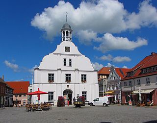
Greifswald, officially the University and Hanseatic City of Greifswald is a city in northeastern Germany.

Rügen Island in the Baltic Sea off the Pomeranian coast of Germany

Rügen is Germany's largest island. It is located off the Pomeranian coast in the Baltic Sea and belongs to the state of Mecklenburg-Western Pomerania.

Vineta is the name of a mythical city at the southern coast of the Baltic Sea. The myth evolved around the tradition about the medieval emporium called Jumne, Jomsborg, Julin or similar names by the chronicles.

Swedish Pomerania Sweden held lands on the southern Baltic coast, including Pomerania and parts of Livonia and Prussia (1630-1815)

Swedish Pomerania was a Dominion under the Swedish Crown from 1630 to 1815, situated on what is now the Baltic coast of Germany and Poland. Following the Polish War and the Thirty Years' War, Sweden held extensive control over the lands on the southern Baltic coast, including Pomerania and parts of Livonia and Prussia.

Hiddensee Municipality in Mecklenburg-Vorpommern, Germany

Hiddensee is a car-free island in the Baltic Sea, located west of Germany's largest island, Rügen, on the German coast.

Ruden (island)

Ruden is a small island in the Baltic Sea, between Rügen and Usedom off the German coast. Ruden belongs to the municipality of Kröslin, in the German state (Bundesland) of Mecklenburg-Western Pomerania. Before the storm tide of All Saints Day in 1304, Ruden was probably part of a land bridge between Usedom and Rügen.

Bay of Greifswald Basin in the German coast of the Baltic Sea

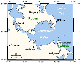
The Bay of Greifswald or Greifswald Bodden is a basin in the southwestern Baltic Sea, off the shores of Germany in the state of Mecklenburg-Vorpommern. With an area of 514 km², it is the largest Bodden of the German Baltic coast.

Wolgast Town in Mecklenburg-Vorpommern, Germany

Wolgast is a town in the district of Vorpommern-Greifswald, in Mecklenburg-Vorpommern, Germany. It is situated on the bank of the river Peenestrom, vis-a-vis the island of Usedom on the Baltic coast that can be accessed by road and railway via a movable bascule bridge. In December 2004, the town had a population of 12,725.

Bodden Brackish bodies of water often forming lagoons, along the southwestern shores of the Baltic Sea

Bodden are briny bodies of water often forming lagoons, along the southwestern shores of the Baltic Sea, primarily in Germany's state of Mecklenburg-Vorpommern. These lagoons can be found especially around the island of Rügen, Usedom and the Fischland-Darss-Zingst peninsula. Some of them are protected reserves, forming the Western Pomerania Lagoon Area National Park.

Koserow Municipality in Mecklenburg-Vorpommern, Germany

Koserow is a municipality on Usedom Island, in the Vorpommern-Greifswald district, in Mecklenburg-Vorpommern, Germany.

Principality of Rügen Former principality

The Principality of Rügen was a Danish principality, formerly a duchy, consisting of the island of Rügen and the adjacent mainland from 1168 until 1325. It was governed by a local dynasty of princes of the Wizlawiden dynasty. For at least part of this period, Rügen was subject to the Holy Roman Empire.

Gustavia, Rügen

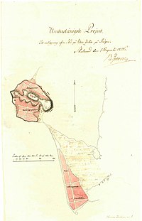
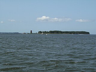
Gustavia was a 19th-century unfinished Swedish town on the island of Rügen, the construction of which began and had to be aborted during the Napoleonic Wars.

Carl Gustaf Wrangel Field Marshal of Sweden (1613–1676)

FältmarskalkCarl Gustaf Wrangel was a Swedish statesman and military commander who commanded the Swedish forces in the Thirty Years', Torstenson, Bremen, Second Northern and Scanian Wars.

Bug (Rügen)

Bug is the name both of the westernmost tongue of land (Landzunge) on the peninsula of Wittow on the German island of Rügen, as well as the name of the former village there. Bug begins south of the village of Dranske and belongs territorially to that municipality.

Southeast Rügen Biosphere Reserve

The Southeast Rügen Biosphere Reserve is a biosphere reserve in the German state of Mecklenburg-Vorpommern, which covers the southeastern part of the island of Rügen, the lagoon of Rügischer Bodden between Putbus and Thiessow, the outer coast between Thiessow and Binz and the island of Vilm.

Stralsund (region)

The Region of Stralsund belonged to the Prussian Province of Pomerania and existed from 1818 to 1932.

Vitslav II, variously called Vislav, Vizlav, Wislaw, Wizlaw and Witslaw in English sources was a prince of Rügen.

Western Pomerania Historical region in present-day northeast Germany

Historical Western Pomerania, also called Fore Pomerania, Front Pomerania or Hither Pomerania, is the western extremity of the historic region of the Duchy, later Province of Pomerania, nowadays divided between the states of Mecklenburg-Western Pomerania and Brandenburg in Germany and West Pomeranian Voivodeship in Poland.

The Wars of the Rügen Succession were two early 14th century conflicts fought primarily between Mecklenburg and Pomerania for control of the Danish Principality of Rügen on the southern Baltic Sea coast.

References

  1. Schreiber, Hermann and Georg (1962). Vanished Cities, pp. 18, 21, 23.
  2. Berckmann, Johann, Stralsundische Chronik.
  3. Nils Petzholdt: Der Mönchgraben bei Baabe und die Landverbindung zwischen Rügen und dem Ruden In: Pommern. Zeitschrift für Kultur und Geschichte. Heft 1/2014, ISSN   0032-4167, pp. 4–8.

Literature