Related Research Articles

The Gulf of Saint Lawrence is the outlet of the North American Great Lakes via the Saint Lawrence River into the Atlantic Ocean. The gulf is a semi-enclosed sea, covering an area of about 226,000 square kilometres (87,000 sq mi) and containing about 34,500 cubic kilometres (8,300 cu mi) of water, which results in an average depth of 152 metres (499 ft).

Digby is a town in southwestern Nova Scotia, Canada. It is the administrative centre and largest population centre in Digby County. The town is situated on the western shore of the Annapolis Basin near the entrance to the Digby Gut, which connects the basin to the Bay of Fundy.

The Mersey River, formerly known as Rivière Rossignol by the Acadians, is a river in Nova Scotia, Canada. It is named after the River Mersey in Liverpool, England. The river proper flows from the eastern end of Eleven Mile Lake in Annapolis County southward to Kejimkujik Lake in Kejimkujik National Park, then through Lake Rossignol to empty into the Atlantic Ocean at the town of Liverpool, Nova Scotia. The true source of the river however is as far northwest as Sandy Bottom Lake or Tuskopeake Brook on the northern tributary.
The Northwest Arm, originally named Sandwich River, is an inlet in eastern Canada off the Atlantic Ocean in Nova Scotia's Halifax Regional Municipality.
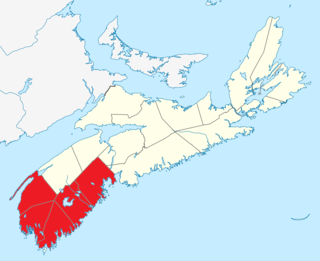
Barrington, officially named the Municipality of the District of Barrington, is a district municipality in western Shelburne County, Nova Scotia, Canada. Statistics Canada classifies the district municipality as a municipal district.
Cape Sable Island, locally referred to as Cape Island, is a small Canadian island at the southernmost point of the Nova Scotia peninsula. It is sometimes confused with Sable Island. Historically, the Argyle, Nova Scotia region was known as Cape Sable and encompassed a much larger area than simply the island it does today. It extended from Cape Negro (Baccaro) through Chebogue.

The Annapolis River is a Canadian river located in Nova Scotia's Annapolis Valley.

Shelburne, officially named the Municipality of the District of Shelburne, is a district municipality comprising the eastern section of Shelburne County, Nova Scotia, Canada. Statistics Canada classifies the district municipality as a municipal district.

The Musquodoboit River is a Canadian river located in central Nova Scotia in the northeastern part of Halifax Regional Municipality. The river is approximately 97 kilometres (60 mi) in length with roughly 88 kilometres (55 mi) being traversable by paddle. It has a watershed area of 1,409 square kilometres (544 sq mi)
Medway River is a river in Queens County, on the southwestern shore of Nova Scotia, Canada. At 121 kilometres long, it is one of the major rivers of Nova Scotia and once supported a large run of Atlantic salmon. Historically, it was an important corridor to the interior waters of Nova Scotia such as Ponhook and Molega Lakes and as a log-driving river for the lumber industry.
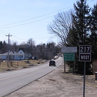
Route 217 is a collector road in the Canadian province of Nova Scotia.
Springfield, Nova Scotia is located between Middleton and Bridgewater. Springfield is in the centre of western Nova Scotia located on Trunk 10, 140 km west of Halifax.
The Shelburne River is a 53 km long river in Nova Scotia, Canada. It is a wilderness river and is a tributary of Mersey River. It starts in the Tobeatic Wilderness Area.
The LaHave River is a 97 km (60 mi) river in Nova Scotia, Canada, running from its source in Annapolis County to the Atlantic Ocean. Along its way, it splits the communities of LaHave and Riverport and runs along the Fairhaven Peninsula and bisects the town of Bridgewater flowing into the LaHave River estuary. Tides affect water levels for about 20 km up the river. There are a number of tourist attractions along the river, and it is also well-used for recreational sailing. As well as two bridges at Bridgewater, the river can be crossed by a cable ferry at the town of LaHave.
Nova Scotia Museum (NSM) is the corporate name for the 27 museums across Nova Scotia, Canada, and is part of the province's tourism infrastructure. The organization manages more than 200 historic buildings, living history sites, vessels, specialized museums and about one million artifacts and specimens, either directly or through a system of co-operative agreements with societies and local boards. The NSM delivers programs, exhibits and products which provide both local residents and tourists in Nova Scotian communities an opportunity to experience and learn about Nova Scotia's social and natural history. More than 600,000 people visit the facilities each year.

The Nova Scotia peninsula is a peninsula on the Atlantic coast of North America.
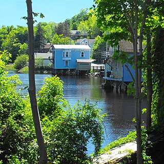
Mill Village is a Canadian rural community in the Region of Queens Municipality, Nova Scotia. It developed in relation to the lumber industry. Located inland from the Atlantic coast, Mill Village was the site of Canada's first satellite earth station constructed in the 1960s.
There are various Black Lakes in Nova Scotia, Canada. They vary widely in size, depth and usability. Many counties, such as Cumberland, Halifax, Inverness, and Pictou Counties have more than one Black Lake so named, while other counties mentioned in this article have only one named Black Lake.
The Bear River is a minor river in western Nova Scotia, Canada. Flowing from south to north, it is 40 kilometres (25 mi) long from its headwaters to its discharge into the Annapolis Basin, some 6 kilometres (3.7 mi) east of Digby. The river is tidal for the last 9.7 kilometres (6.0 mi) of its length. The village of Bear River is situated near the head of the tide where shipbuilding took place in the nineteenth century.
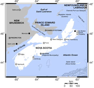
Southern Nova Scotia or the South Shore is a region of Nova Scotia, Canada. The area has no formal identity and is variously defined by geographic, county and other political boundaries. Statistics Canada, defines Southern Nova Scotia as an economic region, composed of Lunenburg County, Queens County, Shelburne County, Yarmouth County, and Digby County. According to Statistics Canada, the region had the highest decrease of population in Canada from 2009 to 2010, with a -10.2% growth rate per thousand. The region also has the second highest median age in Canada at 47.1 years old.
References
- Discover Nova Scotia Gr. 5-7. On The Mark Press. pp. 10–. ISBN 978-1-77072-731-1.
Coordinates: 44°35′16.5″N65°16′53.1″W / 44.587917°N 65.281417°W
| This Nova Scotia location article is a stub. You can help Wikipedia by expanding it. |