
The geography of Switzerland encompasses the geographical features of Switzerland, a mountainous and landlocked country located in Western and Central Europe. Switzerland's natural landscape is marked by its numerous lakes and mountains. It is surrounded by 5 countries: Austria and Liechtenstein to the east, France to the west, Italy to the south and Germany to the north. Switzerland has a maximum north–south length of 220 kilometres (140 mi) and an east–west length of about 350 kilometres (220 mi).

The Rhône is a major river in France and Switzerland, rising in the Alps and flowing west and south through Lake Geneva and southeastern France before discharging into the Mediterranean Sea. At Arles, near its mouth, the river divides into the Great Rhône and the Little Rhône. The resulting delta forms the Camargue region.

The river Ticino is the most important perennial left-bank tributary of the Po. It has given its name to the Swiss canton through which its upper portion flows.

Lake Geneva is a deep lake on the north side of the Alps, shared between Switzerland and France. It is one of the largest lakes in Western Europe and the largest on the course of the Rhône. Sixty per cent of the lake belongs to Switzerland and forty per cent to France.

Valais, more formally the Canton of Valais, is one of the 26 cantons forming the Swiss Confederation. It is composed of thirteen districts and its capital and largest city is Sion. The flag of the canton is made of thirteen stars representing the districts, on a white-red background.

The Great St Bernard Pass is the third highest road pass in Switzerland, at an elevation of 2,469 m (8,100 ft). It connects Martigny in the canton of Valais in Switzerland with Aosta in the region Aosta Valley in Italy. It is the lowest pass lying on the ridge between the two highest mountains of the Alps, Mont Blanc and Monte Rosa. It is located on the main watershed that separates the basin of the Rhône from that of the Po.

The Jungfraujoch is a saddle connecting two major 4000ers of the Bernese Alps: the Jungfrau and the Mönch. It lies at an elevation of 3,463 metres (11,362 ft) above sea level and is directly overlooked by the rocky prominence of the Sphinx. The Jungfraujoch is a glacier saddle, on the upper snows of the Aletsch Glacier, and part of the Jungfrau-Aletsch area, situated on the boundary between the cantons of Bern and Valais, halfway between Interlaken and Fiesch.

The Dujiangyan is an ancient irrigation system in Dujiangyan City, Sichuan, China. Originally constructed around 256 BC by the State of Qin as an irrigation and flood control project, it is still in use today. The system's infrastructure develops on the Min River (Minjiang), the longest tributary of the Yangtze. The area is in the west part of the Chengdu Plain, between the Sichuan Basin and the Tibetan Plateau. Originally, the Min would rush down from the Min Mountains and slow down abruptly after reaching the Chengdu Plain, filling the watercourse with silt, thus making the nearby areas extremely prone to floods. King Zhao of Qin commissioned the project, and the construction of the Dujiangyan harnessed the river using a new method of channeling and dividing the water rather than simply damming it. The water management scheme is still in use today to irrigate over 5,300 km2 (2,000 sq mi) of land in the region and has produced comprehensive benefits in flood control, irrigation, water transport and general water consumption. Begun over 2,250 years ago, it now irrigates 668,700 hectares of farmland.The Dujiangyan, the Zhengguo Canal in Shaanxi and the Lingqu Canal in Guangxi are collectively known as the "three great hydraulic engineering projects of the Qin."

The Verdon Gorge is a river canyon located in the Provence-Alpes-Côte d'Azur region of Southeastern France. It is about 25 km (15.5 mi) long and up to 700 metres (0.4 mi) deep. It was formed by the Verdon River, which is named for its turquoise-green colour, one of the location's distinguishing characteristics. In between the towns of Castellane and Moustiers-Sainte-Marie, the river has cut a ravine to a depth of 700 meters through the limestone mass. At the end of the canyon, the Verdon flows into the artificial Lake of Sainte-Croix.
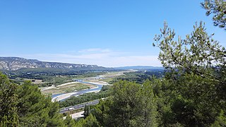
The Durance is a major river in Southeastern France. A left tributary of the Rhône, it is 323.2 km (200.8 mi) long. Its drainage basin is 14,472 km2 (5,588 sq mi).

Andermatt is a mountain village and municipality in the canton of Uri in Switzerland. At an elevation of 1,437 meters (4,715 ft) above sea level, Andermatt is located at the center of the Saint-Gotthard Massif and the historical center cross of north-south and east-west traverses of Switzerland. It is some 28 km (17 mi) south of Altdorf, the capital of Uri.
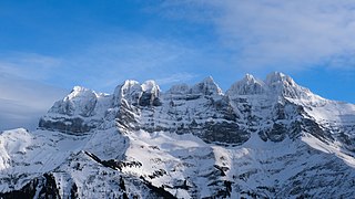
The Dents du Midi are a three-kilometre-long mountain range in the Chablais Alps in the canton of Valais, Switzerland. Overlooking the Val d'Illiez and the Rhône valley to the south, they face the Lac de Salanfe, an artificial reservoir, and are part of the geological ensemble of the Giffre massif. Their seven peaks are, from north-east to south-west: the Cime de l'Est, the Forteresse, the Cathédrale, the Éperon, the Dent Jaune, the Doigts and the Haute Cime. They are mainly composed of limestone rock, with gritty limestone rock in the upper parts.

The Tour du Mont Blanc or TMB is one of the most popular long-distance walks in Europe. It circles the Mont Blanc massif, covering a distance of roughly 165 kilometres (103 mi) with 10 kilometres (6.2 mi) of ascent/descent and passing through parts of Switzerland, Italy and France.

Collombey-Muraz is a municipality in the district of Monthey in the canton of Valais in Switzerland. There was an oil refinery in the town.

La Tzoumaz is a ski resort in the Swiss Alps, in the canton of Valais. It is part of the "Four Valleys" ski area, which consists of various ski resorts, including Verbier, Nendaz, Veysonnaz, La Tzoumaz, and Thyon. As such it has direct access to over 400 km of runs. Named after the word "tzoumer", meaning taking a break, La Tzoumaz nestles against the same mountain as Verbier, Mont Savolyres, and is at the same altitude (1500m). However, unlike Verbier, it is situated on north-facing slopes and hence enjoys a longer ski-season, lasting from early December all the way through to late-April. The resort has splendid views over the Rhone valley from the side of a small sunny valley on the north side of Verbier.
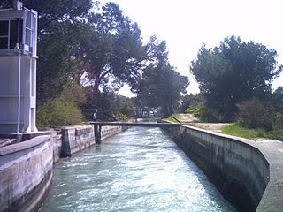
The Canal de Marseille is a major source of drinking water for all of Marseille, the largest city in Provence, France. The canal along its main artery is 80 kilometres (50 mi) long but has additional 160 kilometres (99 mi) of minor arteries. Its construction lasted 15 years and was directed by the engineer Franz Mayor de Montricher; the canal opened on July 8, 1849.

The Wildhorn is a mountain of the Alps, straddling the border between the Swiss cantons of Bern and Valais. At 3,248 metres (10,656 ft) above sea level, it is the highest summit of the Bernese Alps west of the Gemmi Pass. It forms a large glaciated massif, about 10 km wide, extending between the Sanetsch Pass and the Rawil Pass. Along with the Muverans, the Diablerets and the Wildstrubel, the Wildhorn is one of the four distinct mountain massifs of the Bernese Alps that lie west of the Gemmi Pass. The massif of the Wildhorn is at the centre between the valleys of the Saane, Simme and the Rhone (Valais). It comprises several distinct summits, including the Arpelistock, Le Sérac, the Geltenhorn, the Sex Noir, the Sex Rouge, the Schnidehorn and the Six des Eaux Froides. The main crest is between the glaciers named Tungelgletscher and Glacier du Wildhorn. South of the main summit is the almost equally high summit of Mont Pucel. The Wildhorn is surrounded by several large mountain lakes: the Lac de Sénin, the Lauenensee, the Iffigsee, the Lac de Tseuzier and the Lac des Audannes. The Tungelgletscher, on the north-east face, was measured as 1.9 km in length in 1973.

The Lötschberg line is a railway in Switzerland, connecting Spiez in the canton of Bern with Brig in the canton of Valais. It crosses the Bernese Alps, from the Bernese Oberland to Upper Valais, through the Lötschberg Tunnel in the middle of the line. Together with the Simplon Tunnel south of Brig, it constitutes one of the major railways through the Alps and an important north-south axis in Europe. The Lötschberg axis is backed by the lower and longer Lötschberg Base Tunnel, part of the New Railway Links through the Alps project.
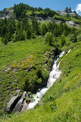
The Salentse is a river in Valais, Switzerland, and a right tributary of the Rhône. Its source is at north of the municipality of Leytron, near of the Grand Muveran. It flows to the South to join the Rhône, in the city of Saillon. During the 1840s, an irrigation canal have been dug to irrigate and bring water in Saillon.

Beauregard Castle is a ruined castle on the territory of Chippis in the canton of Valais, Switzerland. It is situated on a rocky spur at the entrance to the Val d'Anniviers.


