The French Antarctic Expedition is any of several French expeditions in Antarctica.
Bigourdan Fjord is a sound, 12 miles (19 km) long in an east-west direction and averaging 2 miles (3 km) wide, lying between Pourquoi Pas Island and the southwest part of Arrowsmith Peninsula, along the west coast of Graham Land. It was discovered by the French Antarctic Expedition, 1908–10, under Jean-Baptiste Charcot, and named by him for Guillaume Bigourdan, a noted French astronomer. It was roughly surveyed by the British Graham Land Expedition, 1934–37, under John Riddoch Rymill, and resurveyed by the Falkland Islands Dependencies Survey, 1948–50.

Laubeuf Fjord is a sound in Antarctica, 40 kilometres long in a north-south direction and averaging 16 km (10 mi) wide, lying between the east-central portion of Adelaide Island and the southern part of Arrowsmith Peninsula, Graham Land. It connects Hanusse Bay to the north with Marguerite Bay to the south. The southern 'border' between Laubeuf Fjord and Marguerite Bay is formed by the line between Rothera Point, Adelaide Island, and Cape Sáenz, which is the southernmost point of the Arrowsmith Peninsula. The fjord was discovered by the French Antarctic Expedition, 1908–10, under Jean-Baptiste Charcot, and named by him for Maxime Laubeuf, a French marine engineer who supervised building the engine for the ship Pourquoi-Pas.

Bourgeois Fjord is an inlet, 30 miles (50 km) long in a northeast–southwest direction and 3 to 5 miles wide, lying between the east sides of Pourquoi Pas Island and Blaiklock Island and the west coast of Graham Land. It separates Loubet Coast to the north from Fallières Coast to the south. The fjord was discovered by the French Antarctic Expedition, 1908–10, under Jean-Baptiste Charcot, and named by him for Colonel Joseph E. Bourgeois, Director of the Geographic Service of the French Army. The outline of this inlet was more accurately delineated in 1936 by the British Graham Land Expedition under John Rymill.

Blaiklock Island is a high and rugged, irregular-shaped island 17 kilometres (9 nmi) long, lying between Bigourdan Fjord and Bourgeois Fjord. It is separated from Pourquoi Pas Island by The Narrows and from the west coast of Graham Land by Jones Channel. The feature was partially surveyed in 1936 by the British Graham Land Expedition under Rymill, at which time it was charted as a promontory. It was determined to be an island in 1949 by Kenneth V. Blaiklock, a Falkland Islands Dependencies Survey surveyor for whom it is named.
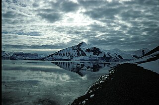
Mount Arronax is an ice-covered, pointed peak, 1,585 m, standing 6 nautical miles (11 km) west-southwest of Nautilus Head and dominating the north part of Pourquoi Pas Island, off the west coast of Graham Land. Black Pass runs northeast–southwest, 3 nautical miles west of Mount Arronax.
Contact Peak is a prominent rock peak, 1,005 metres (3,300 ft) high, which is the southeasternmost peak on Pourquoi Pas Island, off the west coast of Graham Land. It was first sighted and roughly charted in 1909 by the French Antarctic Expedition under Jean-Baptiste Charcot. It was surveyed in 1936 by the British Graham Land Expedition and in 1948 by the Falkland Islands Dependencies Survey (FIDS). It was so named by FIDS because the peak marks the granite-volcanic contact in the cliffs which is visible at a considerable distance.
Nautilus Head is a prominent headland rising to 975 m near the northeast extremity of Pourquoi Pas Island, off the west coast of Graham Land. It was first surveyed in 1936 by the British Graham Land Expedition (BGLE) under Rymill and resurveyed in 1948 by the Falkland Islands Dependencies Survey (FIDS) who named it after the submarine Nautilus in Jules Verne's Twenty Thousand Leagues Under The Sea. Other features on Pourquoi Pas Island are named after characters from that book.
Nemo Cove is a cove midway along the east side of Pourquoi Pas Island, off the west coast of Graham Land. First surveyed in 1936 by the British Graham Land Expedition (BGLE) under Rymill. Resurveyed in 1948 by the Falkland Islands Dependencies Survey (FIDS) and named after Captain Nemo, designer and captain of the submarine Nautilus in Jules Verne's novel Twenty Thousand Leagues Under the Sea. Other features on the island are also named after characters in this book.
Nemo Glacier is a glacier flowing east into Nemo Cove, Pourquoi Pas Island, in northeast Marguerite Bay. Named by United Kingdom Antarctic Place-Names Committee (UK-APC), 1979, in association with Nemo Cove.

The Creswick Peaks, in Antarctica, form an impressive mountain massif with several peaks, the highest at 1,465 metres (4,800 ft), standing at the northeast side of Moore Point between Naess Glacier and Meiklejohn Glacier, and 3 nautical miles (6 km) inland from George VI Sound on the west coast of Palmer Land.
Perplex Ridge is a ridge, rising over 915 m, composed of four rocky masses separated by small glaciers, extending 6 nautical miles (11 km) northeastward from Lainez Point along the northwest side of Pourquoi Pas Island, off the west coast of Graham Land. First sighted and roughly charted in 1909 by the French Antarctic Expedition under Charcot. It was surveyed in 1936 by the British Graham Land Expedition (BGLE) and in 1948 by the Falkland Islands Dependencies Survey (FIDS). So named by FIDS because of confusion in attempting to identify this ridge from earlier maps.
Parvenu Point is a low but prominent point forming the north extremity of Pourquoi Pas Island, off the west coast of Graham Land. First surveyed in 1936 by the British Graham Land Expedition (BGLE) under Rymill. The point was resurveyed in 1948 by the Falkland Islands Dependencies Survey (FIDS) and found to be more conspicuous from the west than had previously been supposed, its new stature thus suggesting the name.
Moider Glacier is a glacier flowing west into the east side of Dalgliesh Bay, Pourquoi Pas Island, in Marguerite Bay, Antarctica. It was named by the UK Antarctic Place-Names Committee in 1979 in association with nearby Perplex Ridge; the word "moider" can be a synonym for "perplex".

Mount Verne is a mountain standing 6 nautical miles (11 km) east of Bongrain Point and dominating the south part of Pourquoi Pas Island, off the west coast of Graham Land. It was first sighted and roughly surveyed in 1909 by the French Antarctic Expedition under Charcot, and then resurveyed in 1948 by the Falkland Islands Dependencies Survey (FIDS). It was named by them for Jules Verne, the author of Twenty Thousand Leagues Under the Sea. Other features on Pourquoi Pas Island are named after characters in this book.
Ridge Island is a ridge-shaped island, 6 nautical miles (11 km) long and 1.5 nautical miles (2.8 km) wide lying 3 nautical miles (6 km) east of Pourquoi Pas Island in the center of Bourgeois Fjord, off the west coast of Graham Land. Discovered and named by the British Graham Land Expedition (BGLE), 1934–37, under Rymill.
Lainez Point is a point which forms the north side of the entrance to Dalgliesh Bay on the west side of Pourquoi Pas Island, off the west coast of Graham Land, Antarctica. It was discovered by the French Antarctic Expedition, 1908–10, under Jean-Baptiste Charcot, and named by him for Manuel Lainez, a senator of the Argentine Republic and founder of the newspaper El Diario.
Landauer Point is a point on the east coast of Adelaide Island, marking the west side of the north entrance to Tickle Channel in Graham Land, Antarctica. It was mapped by the Falkland Islands Dependencies Survey from air photos taken by the Ronne Antarctic Research Expedition, 1947–48, and the Falkland Islands and Dependencies Aerial Survey Expedition, 1956–57. The point was named by the UK Antarctic Place-Names Committee for Joseph K. Landauer, an American physicist who has studied the mechanical properties of ice and glacier flow.


