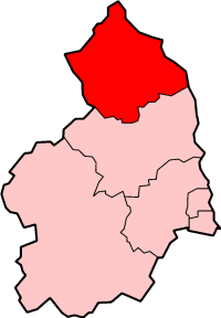
Berwick-upon-Tweed was a local government district and borough in Northumberland in the north-east of England, on the border with Scotland. The district had a resident population of 25,949 according to the 2001 census, which also notes that it is the most ethnically homogeneous in the country, with 99.6% of the population recording themselves in the 2001 census as White. It was also the least populated district in England with borough status, and the third-least densely populated local government district (after Eden and Tynedale).
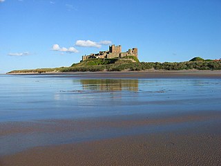
Its main town is Berwick-upon-Tweed, sited immediately to the north of the Tweed estuary. The town is ancient, the scene of a number of battles; it has perhaps the best remaining example of a (almost completely intact) town wall, built for defensive purposes.
On the south of the estuary, the port of Tweedmouth is the point of export of diverse goods, but especially grain and roadstone. The remainder of the borough is rural, bordered to the west by the Cheviot Hills, and to the east by a scenic coastline.
Berwick was the first district in Britain to hold a referendum on whether to have a directly elected mayor. This referendum, on 7 June 2001, decided against an elected mayor.
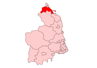
Northumberland is a ceremonial and historic county in North East England, bordering Scotland. It is bordered by the Scottish Borders to the north, the North Sea to the east, Tyne and Wear and County Durham to the south, and Cumbria to the west. The town of Blyth is the largest settlement.
Berwick-upon-Tweed, sometimes known as Berwick-on-Tweed or simply Berwick, is a town and civil parish in Northumberland, England, 2+1⁄2 mi (4 km) south of the Anglo-Scottish border, and the northernmost town in England. The 2011 United Kingdom census recorded Berwick's population as 12,043.
Belford is a village and civil parish in Northumberland, England, about halfway between Alnwick and Berwick-upon-Tweed, a few miles inland from the east coast and just off the Great North Road, the A1. At the 2001 census it had a population of 1,055, increasing to 1,258 at the 2011 Census.
Islandshire was an area of Northumberland, England, comprising Lindisfarne or Holy Island, plus five parishes on the mainland.
Politics of England forms the major part of the wider politics of the United Kingdom, with England being more populous than all the other countries of the United Kingdom put together. As England is also by far the largest in terms of area and GDP, its relationship to the UK is somewhat different from that of Scotland, Wales or Northern Ireland. The English capital London is also the capital of the UK, and English is the dominant language of the UK. Dicey and Morris (p26) list the separate states in the British Islands. "England, Scotland, Northern Ireland, the Isle of Man, Jersey, Guernsey, Alderney, and Sark.... is a separate country in the sense of the conflict of laws, though not one of them is a State known to public international law." But this may be varied by statute.
Alnwick was a local government district of Northumberland, England. Its council was based in the town of Alnwick and the district had a population of 31,029 according to the 2001 census.
Hexham is a constituency in Northumberland represented in the House of Commons of the UK Parliament since 2010 by Guy Opperman, a Conservative. As with all constituencies, the constituency elects one Member of Parliament (MP) by the first past the post system of election at least every five years.
Lowland Scottish Omnibuses Ltd was a bus operator in south eastern Scotland and parts of Northern England. The company was formed in 1985 and operated under the identities Lowland Scottish, Lowland and First Lowland / First SMT, until 1999 when the company's operations were combined with the operations of Midland Bluebird in a new company, First Edinburgh Ltd. As of 26 March 2017 these operations were transferred to West Coast Motors.
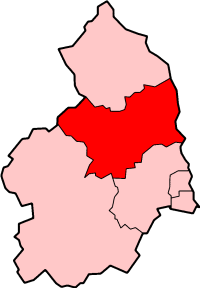
Berwick-upon-Tweed is a parliamentary constituency in Northumberland represented in the House of Commons of the UK Parliament since 2015 by Anne-Marie Trevelyan, a Conservative.
Berwick-upon-Tweed Borough Council elections were generally held every four years between the council's creation in 1974 and its abolition in 2009. The Borough of Berwick-upon-Tweed was a non-metropolitan district in Northumberland, England. The council was abolished and its functions transferred to Northumberland County Council with effect from 1 April 2009.
This timeline summarises significant events in the history of Northumbria and Northumberland.
Norham and Islandshires was a rural district in Northumberland, England from 1894 to 1974.
The Anglo-Scottish border is a border separating Scotland and England which runs for 96 miles (154 km) between Marshall Meadows Bay on the east coast and the Solway Firth in the west.
The Northumberland Coast is a designated Area of Outstanding Natural Beauty (AONB) covering 40 miles (64 km) of coastline from Berwick-Upon-Tweed to the River Coquet estuary in the Northeast of England. Features include: Alnmouth, Bamburgh, Beadnell, Budle Bay, Cocklawburn Beach, Craster, Dunstanburgh Castle, the Farne Islands, Lindisfarne and Seahouses. It lies within the natural region of the North Northumberland Coastal Plain.
Middleton is a settlement and civil parish in Northumberland, England. The parish is situated on the North Sea coast, south of the island of Lindisfarne, and contains the villages of Ross, Detchant and Elwick; all are shrunken medieval villages. Both the A1 London to Edinburgh road and East Coast Main Line pass through the parish. In the 2001 census the parish had a population of 136, falling to 115 at the 2011 Census.
Scremerston is a village in Northumberland, England. The village lies on the North Sea coast just under 2.5 miles (4 km) south of Berwick-upon-Tweed and 4.3 miles (7 km) from the Anglo-Scottish border. It is adjacent to the A1, providing access to Newcastle upon Tyne to the south, and to Edinburgh to the north.
The Liberties of Berwick are coterminous with the parish of Holy Trinity and St. Mary. They comprise the town of Berwick-upon-Tweed and a rural area to the north and west. For several centuries the Bounds of the liberties have been ridden on horseback each year on May Day.
The county of Northumberland has returned four MPs to the UK Parliament since 1983. Under the Local Government Act 1972, which came into effect on 1 April 1974, the boundaries of the historic/administrative county were significantly altered with the south-east of the county, comprising more than half the electorate, being transferred to the new metropolitan county of Tyne and Wear. These changes were reflected in the following redistribution of parliamentary seats which did not come into effect until the 1983 general election, resulting in a reduction in the county's representation from 10 to 4 MPs.
This page is based on this Wikipedia article Text is available under the CC BY-SA 4.0 license; additional terms may apply. Images, videos and audio are available under their respective licenses.