
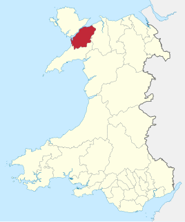
Cemais was one of the three medieval cantrefs on the island of Anglesey, north Wales, in the Kingdom of Gwynedd. It lay on the northern side of the island on the Irish Sea.
The cantref consisted of the two cwmwds of Talybolion and Twrcelyn.
Cemais was one of the three medieval cantrefs on the island of Anglesey, north Wales, in the Kingdom of Gwynedd. It lay on the northern side of the island on the Irish Sea.
The cantref consisted of the two cwmwds of Talybolion and Twrcelyn.
Coordinates: 53°25′N4°26′W / 53.41°N 4.44°W
| | This Anglesey location article is a stub. You can help Wikipedia by expanding it. |

Central Frontenac is a township in eastern Ontario, Canada in the County of Frontenac.
Arfon was one of five districts of Gwynedd, Wales, from 1974 to 1996.

Thunder Bay is a bay in the U.S. state of Michigan on Lake Huron. The bay extends from North Point at 45°01′19″N83°15′58″W to South Point at 44°53′00″N83°18′51″W.

The Halifax Regional Municipality has a number of parks and recreation areas in urban and rural settings.

The mediaeval Welsh cantref of Arfon in north-west Wales was the core of the Kingdom of Gwynedd. Later it was included in the new county of Caernarfonshire, together with Llŷn and Arllechwedd under the terms of the Statute of Rhuddlan in 1284. The island of Anglesey faced it across the Menai Strait; to the east was the cantref of Arllechwedd, to the south the cantref of Eifionydd, and to the west was the cantref of Llŷn.
The ancient Welsh cantref of Arllechwedd in north-west Wales was part of the kingdom of Gwynedd for much of its history until it was included in the new county of Caernarfonshire, together with Arfon and Llŷn under the terms of the Statute of Rhuddlan in 1284.
Digby Neck is a Canadian peninsula extending into the Bay of Fundy in Digby County, Nova Scotia.

Glywysing was, from the sub-Roman period to the Early Middle Ages, a petty kingdom in south-east Wales. Its people were descended from the Iron Age tribe of the Silures, and frequently in union with Gwent, merging to form Morgannwg.

The Hundred of Dungleddy was a hundred in the centre of Pembrokeshire, Wales. It had its origins in the pre-Norman cantref of Deugleddyf. It derives its Welsh name from its position between the two branches of the River Cleddau (Cleddyf): the English form is a corruption of the Welsh. The area of the cantref was around 185 km2: it was the smallest of the seven cantrefi of Dyfed.
The Kingdom of Ceredigion was one of several Welsh kingdoms that emerged in 5th-century post-Roman Britain. Cardigan Bay to the west and the surrounding hilly geography made it difficult for foreign invaders to conquer. Its area corresponded roughly to that of the county of Ceredigion. Ceredigion transparently means "the people of Ceredig."

The Hundred of Narberth was a hundred in Pembrokeshire, Wales. An administrative and legal division, it was formed by the Act of Union of 1536 from parts of the pre-Norman cantrefs of Penfro and Cantref Gwarthaf.

Cantref Gwarthaf was the largest of the seven cantrefi of Dyfed in southwest Wales. It subsequently became part of Deheubarth in around 950. It consisted of the southeastern part of Dyfed containing most of the basin of the River Tâf, parts of modern-day Pembrokeshire and Carmarthenshire.
Kelsey is a rural municipality in the province of Manitoba in Western Canada. It consists of several disjoint parts. The largest part is Carrot Valley, located around and southwest of The Pas along the Carrot River, but the communities of Wanless and Cranberry Portage, located further north, are also part of the municipality. It is 867.64 km2 large. Also lying in the area around The Pas is the Opaskwayak Cree Nation Indian reserve.

Aberffraw was one of the three medieval cantrefs on the island of Anglesey, north Wales, in the Kingdom of Gwynedd. It lay on the western side of the island on Caernarfon Bay. Its administrative centre was Aberffraw, ancient seat of the Princes of Gwynedd.
Dindaethwy was in medieval times one of two commotes of the cantref of Rhosyr, in the south-east of the Isle of Anglesey. It was between the Menai Strait and Conwy Bay, and the Irish Sea and Red Wharf Bay.

Antigua and Barbuda lie in the eastern arc of the Leeward Islands of the Lesser Antilles, separating the Atlantic Ocean from the Caribbean Sea. Antigua is 650 km (400 mi) southeast of Puerto Rico; Barbuda lies 48 km (30 mi) due north of Antigua, and the uninhabited island of Redonda is 56 km (35 mi) southwest of Antigua.
Caereinion was a medieval cantref in the Kingdom of Powys, or possibly it was a commote (cwmwd) within a cantref called Llŷs Wynaf. It was divided into the manors of Uwch Coed and Is Coed.