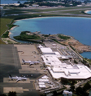
L.F. Wade International Airport, formerly named Bermuda International Airport, is the sole airport serving the British overseas territory of Bermuda in the North Atlantic Ocean. It is located in the parish of St. George's and is 6 NM northeast of Bermuda's capital, Hamilton. In 2016, L.F. Wade International Airport handled about 402,925 passengers, up 5.6% from 2006. It has one passenger terminal, one cargo terminal, eight aircraft stands and can support all aircraft sizes up to and including the Airbus A380. Currently, eight passenger or cargo airlines operate seasonal or year-round scheduled services to Bermuda Airport from Canada, the United Kingdom, and the United States.

Loch Leven is a fresh water loch located immediately to the east of the burgh of Kinross in Perth and Kinross council area, central Scotland. Roughly triangular, the loch is about 6 km (3.7 mi) at its longest. Prior to the canalisation of the River Leven, and the partial draining of the loch in 1826–36, Loch Leven was considerably larger. The drop in water level by 1.4 m reduced the loch to 75% of its former size, and exposed several small islands, as well as greatly increasing the size of the existing ones.

Kindley Air Force Base was a United States Air Force base in Bermuda from 1948–1970, having been operated from 1943 to 1948 by the United States Army Air Forces as Kindley Field.
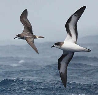
The Bermuda petrel is a gadfly petrel. Commonly known in Bermuda as the cahow, a name derived from its eerie cries, this nocturnal ground-nesting seabird is the national bird of Bermuda and can be found pictured on Bermudian currency. It is the second rarest seabird on the planet and a symbol of hope for nature conservation. They are known for their medium-sized body and long wings. The Bermuda petrel has a greyish-black crown and collar, dark grey upper-wings and tail, white upper-tail coverts and white under-wings edged with black, and the underparts are completely white.

Stonington Island is a rocky island lying 1.8 km (1.1 mi) northeast of Neny Island in the eastern part of Marguerite Bay off the west coast of Graham Land, Antarctica. It is 0.75 km (0.47 mi) long from north-west to south-east and 0.37 km (0.23 mi) wide, yielding an area of 20 ha. It was formerly connected by a drifted snow slope to Northeast Glacier on the mainland. Highest elevation is Anemometer Hill which rises to 25 m (82 ft).

Devonshire Parish is one of the nine parishes of Bermuda. Originally named Cavendish Tribe and later Devonshire Tribe, for William Cavendish, 1st Earl of Devonshire (1552–1626). Devonshire Redoubt, on Castle Island, one of the Castle Harbour fortifications of St. George's Parish, was also named after him.

Hamilton Parish is one of the nine parishes of Bermuda. It was renamed for Scottish aristocrat James Hamilton, 2nd Marquess of Hamilton (1589-1625) when he purchased the shares originally held in the Virginia Company by Lucy Russell, Countess of Bedford.
St. George's Parish is one of the nine parishes of Bermuda. It is named after the founder of the Bermuda colony, Admiral Sir George Somers.

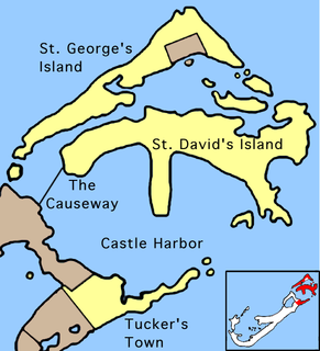
The Causeway is a narrow strip of reclaimed land and bridges in the north of Bermuda linking Hamilton Parish on the mainland in the southwest and Bermuda International Airport on St. David's Island in St. George's Parish in the northeast, which are otherwise divided by Castle Harbour.
Castle Harbour is a large natural harbour in Bermuda. It is located between the northeastern end of the main island and St. David's Island. Originally called Southampton Port, it was renamed as a result of its heavy fortification in the early decades of the Seventeenth century.

Nonsuch Island is part of the chain of islands which make up Bermuda. It is in St George's Parish, in the northeast of Bermuda. It is 5.7 ha in area and is at the east entrance to Castle Harbour, close to the south-easternmost point of Cooper's Island. Among the island's charted features is a bay called Nonsuch Bay.

St. George's Harbour is a natural harbour in the north of Bermuda. It serves as the port for the town of St. George's, located on St. George's Island, to its north. To its south is St. David's Island. The harbour and both islands lie within St. George's Parish. It was for two centuries the primary harbour of the British Overseas Territory.
St. David's Island is one of the main islands of the British Overseas Territory of Bermuda. It is located in the far north of the territory, one of the two similarly sized islands that make up the majority of St. George's Parish.

JM Barker (Hapupu) National Historic Reserve was created to protect 33 hectares of kopi forest containing Moriori tree carvings called momori-rakau.
Naval Air Station Bermuda, was located on St. David's Island in the British Colony of Bermuda from 1970 to 1995, on the former site of Kindley Air Force Base. It is currently the site of Bermuda International Airport.

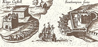
Several of the islands strung across the South entrance of Castle Harbour, Bermuda were fortified in the early days of the territory, hence the harbour's name. When official settlement of the archipelago by England began in 1612 the first permanent town, St. George's was placed on the North side of St. George's Harbour. St. George's Harbour could be accessed directly by channels from the East. Those channels, however, were shallow, suitable, originally, only for small ships. As a consequence, and despite any major settlement on its shores, Castle Harbour was an important anchorage in the early years of the colony, with its main entrance, Castle Roads being an important route in from the open Atlantic for shipping. It was also a weakpoint, as it was remote from the defences of St. George's Harbour, and difficult to reach. It was quickly fortified and garrisoned by a standing militia.
Castle Roads is the primary channel by which vessels enter Castle Harbour, Bermuda, from the Atlantic Ocean. Although little used, today, except by pleasure boats, Castle Harbour was once an important anchorage, and an access route used by ships to reach the still important St. George's Harbour. The infilling of waterways between St. David's Island and Long Bird Island in the 1940s, as well as the Causeway joining the contiguous landmass so created means only small boats can pass between the two Harbours, today. It was once common to use the term roads in reference to a waterway. Other examples include Hampton Roads, in Virginia, and Lahaina Roads, in Hawaii.
Coffin Island is an island that is located in the Great Southern region of Western Australia. The island is 300 metres (984 ft) offshore from Two Peoples Bay Nature Reserve and the island is also a protected area making up part of the reserve. With an area of 28 hectares the island is made up mostly of granite.

The Hunter Estuary Wetlands comprise a group of associated wetlands at and near the mouth of the Hunter River in the city of Newcastle, New South Wales, Australia. Some 30 km2 of the wetlands has been recognised as being of international importance by designation under the Ramsar Convention. It was listed on 21 February 1984 as Ramsar site 287. A larger area of the wetlands has been identified by BirdLife International as an Important Bird Area (IBA). The wetlands are recognised as the most important area in New South Wales for waders, or shorebirds.

The Bermuda Base Command was a command of the United States Army, established to defend the British Colony of Bermuda, located 640 miles off Cape Hatteras, North Carolina. It was created in April 1941 when United States Army troops were sent to the island.
