
Anne Arundel County, also notated as AA or A.A. County, is a county located in the U.S. state of Maryland. As of the 2010 United States Census, its population was 537,656, a population increase of just under 10% since 2000. Its county seat is Annapolis, which is also the capital of the state. The county is named for Lady Anne Arundell (1615–1649), a member of the ancient family of Arundells in Cornwall, England, and the wife of Cecilius Calvert, 2nd Baron Baltimore (1605–1675), founder and first Lord Proprietor of the colony Province of Maryland.
Interstate 97 (I-97) is a part of the Interstate Highway System that runs entirely within Anne Arundel County, Maryland. The Interstate runs 17.62 miles (28.36 km) from U.S. Route 50 (US 50) and US 301 in Parole near Annapolis north to I-695 and I-895 in Brooklyn Park near Baltimore. The Interstate is the primary highway between Baltimore and Annapolis. I‑97 connects Annapolis with Baltimore–Washington International Airport and links the northern Anne Arundel County communities of Crownsville, Millersville, Severna Park, Glen Burnie, and Ferndale. It is the second shortest primary Interstate Highway after I-87 in North Carolina.

Arnold is a suburb of Annapolis and a census-designated place (CDP) in Anne Arundel County, Maryland, United States. The population was 23,106 at the 2010 census. Neighborhoods straddle College Parkway and Maryland Route 2. Arnold is located on the scenic Broadneck peninsula. The ZIP code is 21012.

Brooklyn Park is a census-designated place (CDP) in Anne Arundel County, Maryland, United States. The population was 14,373 at the 2010 census.

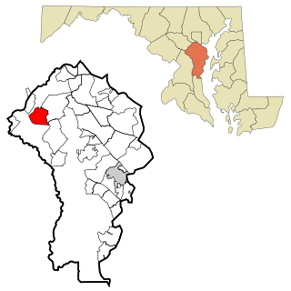
Crownsville is a census-designated place (CDP) in Anne Arundel County, Maryland, United States. The population was 1,757 at the 2010 census. It hosts the Anne Arundel County Fair each September, as well as the annual Maryland Renaissance Festival for several summer weekends. A state psychiatric hospital was formerly in Crownsville. The area offers waterfront scenery and easy access to urban metropolitan areas and culture.
Fort Meade is a census-designated place (CDP) in Anne Arundel County, Maryland, United States. The population was 9,327 at the 2010 census. It is the home to the National Security Agency, Central Security Service, United States Cyber Command and the Defense Information Systems Agency, which are located on the U.S. Army post Fort George G. Meade.

Linthicum is a census-designated place (CDP) and unincorporated community in Anne Arundel County, Maryland, United States. The population was 10,324 at the 2010 census. It is located directly north of Baltimore–Washington International Thurgood Marshall Airport (BWI).

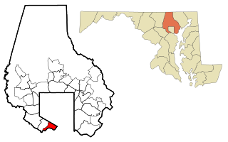
Odenton is a census-designated place (CDP) in Anne Arundel County, Maryland, United States, located approximately 10–20 minutes from the state capital, Annapolis. The population was 37,132 at the 2010 census, up from 20,534 at the 2000 census. The town's population growth rate of 80.8% between 2000 and 2010 was the greatest of any town in western Anne Arundel County. Odenton is located west of Annapolis, south of Baltimore, and northeast of Washington.

Parole, a suburb of Annapolis, is a census-designated place (CDP) in Anne Arundel County, Maryland, United States. The population was 15,922 at the 2010 census. It is where several major roads intersect at the western edge of the state capital, Annapolis, and adjacent to the Annapolis Mall shopping center and Anne Arundel Medical Center. The neighborhood was named because it was a parole camp, where Union and Confederate prisoners of war were brought for mutual exchange and eventual return to their respective homes.

Pasadena is a census-designated place (CDP) in Anne Arundel County, Maryland, United States. The population was 24,287 at the 2010 census.

Elkridge is an unincorporated community and census-designated place (CDP) in Howard County, Maryland, United States. The population was 15,593 at the 2010 census. Founded early in the 18th century, Elkridge is located at the confluence of three counties, the other two being Anne Arundel and Baltimore counties.

Clarksville is an unincorporated community in Howard County, Maryland; the second highest-earning county in the United States according to the U.S. Census Bureau. The community is named for William Clark, a farmer who owned much of the land on which the community now lies and served as a postal stop that opened on the 4th of July 1851.
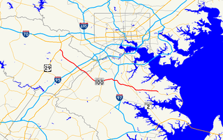
Maryland Route 100 is a major east–west highway connecting U.S. Route 29 in Ellicott City and MD 177 in Pasadena. MD 100 also connects to Interstate 95 (I-95), US 1, the Baltimore–Washington Parkway, and I-97. The highway connects Howard County to the west with Anne Arundel County and the Chesapeake Bay to the east. MD 100 also provides access to the Baltimore–Washington International Airport (BWI) and the Arundel Mills shopping mall.
Baltimore Highlands is a census-designated place (CDP) in Baltimore County, Maryland, United States, directly south of the city of Baltimore. The population was 7,019 at the 2010 census. At the 2000 census and earlier, the area was delineated as part of the Lansdowne-Baltimore Highlands CDP.

Blandair, also known as Blandair Farm, Blandair Park, and Blandair Regional Park, is 300 acres of former slave plantation located in Columbia, Maryland. The Blandair Foundation estate of Mrs. Smith was purchased by Howard County, Maryland in the late 1990s and is in the process of being developed as a regional park.
The South River is a 10-mile-long (16 km) tributary of the Chesapeake Bay in Anne Arundel County, Maryland in the United States. It lies south of the Severn River, east of the Patuxent River, and north of the West River and Rhode River, and drains to the Chesapeake Bay.
The Eisenhower Golf Club, named after U.S. President Dwight Eisenhower, is the golf course located at Crownsville, Maryland in Anne Arundel County. Just a mile from Maryland capital Annapolis, home of the United States Naval Academy. Golf course was created by golf architect Ed Auit in 1969 on a 220 acres splendidly wooded landscape, takes golfers though forestland, around one of Maryland's finest lakes, and alongside numerous creeks and swales. This course is run by Billy Casper Golf. This course is an 18-hole public golf course, 70/71 par course. At the Ike is 6,659 yards with the slope of 126. The Back is 6,288 yards, slope of 121. The Middle is 5,876 yards, slope of 118. The Front is 4,884 yards, slope of 108.
The Little Magothy River runs 2.5 miles (4.0 km) through Anne Arundel County in the U.S. state of Maryland. It is located southeast of the Magothy River, just outside its mouth and north of the Severn River.
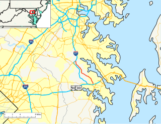
Maryland Route 178 is a state highway in the U.S. state of Maryland. Known as Generals Highway, the highway runs 8.06 miles (12.97 km) from MD 450 in Parole north to Veterans Highway near Millersville. MD 178 connects Annapolis with Crownsville in central Anne Arundel County. The highway is indirectly named for George Washington, who traveled the highway in 1783 on his way to Annapolis to resign his commission in the Continental Army at the conclusion of the American Revolutionary War. MD 178 was planned as early as 1910 as part of a western route between Baltimore and Annapolis. However, most of the highway south of MD 3 was not built until the early 1930s. The portion south of MD 3 served as a primary segment in the western corridor connecting Baltimore–Annapolis, until the construction of Interstate 97 (I-97) in the late 1980s.