The Los Angeles County Metropolitan Transportation Authority (LACMTA), branded as Metro, is the county agency that plans, operates, and coordinates funding for most of the public transportation system in Los Angeles County, California, the most populated county in the United States.

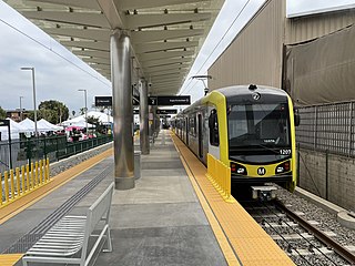
The C Line is a 19.3-mile (31.1 km) light rail line running between Redondo Beach and Norwalk within Los Angeles County, California. It is one of six lines forming the Los Angeles Metro Rail system and opened on August 12, 1995. Along the route, the line serves the cities of Downey, El Segundo, Hawthorne, Norwalk and Lynwood, the Los Angeles community of Westchester, and several unincorporated communities in the South Los Angeles region including Athens, Del Aire, and Willowbrook. A free shuttle bus to Los Angeles International Airport (LAX) is available at the line's Aviation/LAX station.

Aviation/LAX station is an elevated light rail station on the C Line of the Los Angeles Metro Rail system. It is located over Aviation Boulevard, after which the station is named, near its intersection with Imperial Highway and south of Century Freeway in Los Angeles, California. It opened as part of the Green Line on August 12, 1995. The station was initially named Aviation Blvd/I-105, but in 2003, it was simplified and renamed Aviation/LAX to highlight its proximity to Los Angeles International Airport.

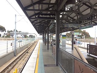
Willowbrook/Rosa Parks station is a major transport hub and Los Angeles Metro Rail station that serves the A Line and C Line. The station, located at the intersection of Imperial Highway and Wilmington Avenue in the Willowbrook community of Los Angeles County, is a major transfer point for commuters.
Avalon station is a elevated light rail station on the C Line of the Los Angeles Metro Rail system. It is located in the median of Interstate 105, above Avalon Boulevard, after which the station is named, in the unincorporated neighborhood of Green Meadows.

Long Beach Boulevard station is a elevated light rail station on the C Line of the Los Angeles Metro Rail system. It is located in the median of Interstate 105, above Long Beach Boulevard, after which the station is named, in the city of Lynwood, California.

Harbor Freeway station is a transport hub located on the Harbor Transitway, within the Judge Harry Pregerson Interchange of Interstate 105 and Interstate 110 near Figueroa Street in the neighborhood of South Los Angeles. The station is served by the light rail C Line, the bus rapid transit J Line and other bus services. The station is owned by the California Department of Transportation (Caltrans) and operated by the Los Angeles County Metropolitan Transportation Authority (Metro).

Vermont/Athens station is a below-grade light rail station on the C Line of the Los Angeles Metro Rail system. It is located in the median of Interstate 105, below Vermont Avenue, after which the station is named along with the Athens community where it is located.

Crenshaw station is a elevated light rail station on the C Line of the Los Angeles Metro Rail system. It is located in the median of Interstate 105, above Crenshaw Boulevard, after which the station is named, in the city of Hawthorne, California.
Mariposa station is an elevated light rail station on the C Line of the Los Angeles Metro Rail system. It is located over Mariposa Avenue, after which the station is named, alongside Nash Street in El Segundo, California. It opened with the commencement of Green Line service on August 12, 1995. By 2024, Mariposa station will be served by the K Line after it gets extended to Redondo Beach and the C Line gets rerouted to LAX Airport at the future LAX/Metro Transit Center station.

El Segundo station is an elevated light rail station on the C Line of the Los Angeles Metro Rail system. It is located over El Segundo Boulevard, after which the station is named, near its intersection with Nash Street in El Segundo, California. It opened with the commencement of Green Line service on August 12, 1995. By 2024, El Segundo station will be served by the K Line after it gets extended to Redondo Beach and the C Line gets rerouted to LAX Airport at the future LAX/Metro Transit Center station.

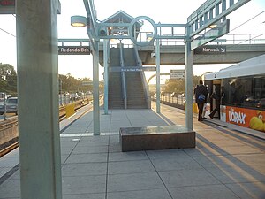
Redondo Beach station is an elevated light rail station on the C Line of the Los Angeles Metro Rail system. It is located over Marine Avenue in the city of Redondo Beach, California, after which the station is named. It opened with the commencement of Green Line service on August 12, 1995. The station is currently the western terminus of the C Line. By 2024, Redondo Beach station will be served by the K Line after it gets extended there and the C Line gets rerouted to LAX Airport at the future LAX/Metro Transit Center station.

Harbor Gateway Transit Center, formerly Artesia Transit Center, is a large bus station at the southern end of the Harbor Transitway that serves as a transport hub for the South Bay region of Los Angeles County including the Harbor Gateway neighborhood of Los Angeles and cities of Carson, Gardena, and Torrance. The station consists of one large island platform with 12 bus bays and a 980 space park and ride parking lot located in the southwest corner of Interstate 110 and California State Route 91.

Douglas station is an elevated light rail station on the C Line of the Los Angeles Metro Rail system. It is located over Douglas Street, after which it is named, near Park Place and one block north of Rosecrans Avenue in El Segundo, California. It opened with the commencement of Green Line service on August 12, 1995. By 2024, Douglas station will be served by the K Line after it gets extended to Redondo Beach and the C Line gets rerouted to LAX Airport at the future LAX/Metro Transit Center station.

Fillmore station is an at-grade light rail station on the A Line of the Los Angeles Metro Rail system. It is located on Fillmore Street, after which the station is named, between Raymond Avenue and Arroyo Parkway in Pasadena, California. The station opened on July 26, 2003, as part of the original Gold Line, then known as the "Pasadena Metro Blue Line" project.

Memorial Park station is a below-grade light rail station on the A Line of the Los Angeles Metro Rail system. It is located at Holly Street and at the end of Arroyo Parkway in Pasadena, California. The station is named after the nearby Memorial Park and is situated on the northern edge of Old Town Pasadena.

GTrans is a municipal transit agency that serves Gardena, California and surrounding Los Angeles County neighbourhoods. It was founded on January 15, 1940, as Gardena Municipal Bus Lines. On the agency's 75th anniversary, the agency was renamed as GTrans. The bus lines complement the Los Angeles County Metropolitan Transportation Authority's crosstown routes through the city. In 2023, the system had a ridership of 2,131,500, or about 8,900 per weekday as of the fourth quarter of 2023.
APU/Citrus College station is an at-grade light rail station on the A Line of the Los Angeles Metro Rail system. It is located between Palm Drive and Citrus Avenue, a block north of Foothill Boulevard, in Azusa, California. It is named after the nearby Azusa Pacific University (APU) and Citrus College.
Fairview Heights station is an at-grade light rail station on the K Line of the Los Angeles Metro Rail system. It is located alongside Redondo Boulevard and near the intersection of Florence Avenue and West Boulevard in Inglewood but near the Hyde Park neighborhood of Los Angeles.

Downtown Inglewood station is an at-grade light rail station on the K Line of the Los Angeles Metro Rail system. It is located alongside Florence Avenue between Market and Locust Streets in the central business district of the city of Inglewood, California.