Heart's Content, Newfoundland and Labrador

Last updated

Heart's Content
Town
Canada Newfoundland location map.svg
Red pog.svg
Heart's Content
Location of Heart's Content in Newfoundland
Coordinates: 47°52′13″N53°21′52″W / 47.87028°N 53.36444°W / 47.87028; -53.36444
CountryFlag of Canada (Pantone).svg  Canada
Province Flag of Newfoundland and Labrador.svg  Newfoundland and Labrador
Settled1677
Government
  MayorFred Cumby
Area
  Total62.81 km2 (24.25 sq mi)
Population
 (2021)
  Total330
Time zone UTC−03:30 (Newfoundland Time)
  Summer (DST) UTC−02:30 (Newfoundland Daylight)
Area code 709
Highways NL Route 74.svg Route 74
NL Route 80.svg Route 80
Heart's Content Lighthouse OOjs UI icon edit-ltr-progressive.svg
NL 2010-04-25 14-43-18 (4553040194).jpg
Coordinates 45°52′56.5″N53°23′07.0″W / 45.882361°N 53.385278°W / 45.882361; -53.385278
Constructed1901
Foundationconcrete base
Constructioncast iron tower
Height8.8 metres (29 ft)
Shapecylindrical tower with balcony and lantern
Markingswhite and red spiral painted tower, white lantern roof
OperatorCanadian Coast Guard [1] [2]
Heritageheritage lighthouse  OOjs UI icon edit-ltr-progressive.svg
Focal height25.5 metres (84 ft)
Range8 nautical miles (15 km; 9.2 mi)
Characteristic Oc. W 6s.

Heart's Content is an incorporated town in Trinity Bay on the Bay de Verde Peninsula of Newfoundland and Labrador, Canada.

Contents

Geography

The natural harbour that makes up the town is located on the east side of Trinity Bay and it is built along the northeast side and the southeast base of this harbour. It opens out to Trinity Bay in a generally southwestern direction and protected from the harsh northern and eastern winds of the North Atlantic. Heart's Content is also at the crossroads of the main highway for Trinity Bay on the western side of the Bay de Verde peninsula and the highway cutting across the Bay de Verde peninsula between Victoria on the Conception Bay side and Heart's Content. The climate of the Atlantic Ocean and adjacent land areas is influenced by the temperatures of the surface waters and water currents as well as the winds blowing across the waters. Because of the oceans' great capacity for retaining heat, the climate of Heart's Content is moderate and free of extreme seasonal variations.

Precipitation falls on the area both as snow in the wintertime and moderate rainfall in summer.

The Gulf Stream and Labrador Current converge just off the coast of Newfoundland and provide for very dense fog that can linger in the area for days.

Transatlantic cable

Heart's Content was given its place in the history of international communications by Cyrus West Field who chose it as the terminus of his Transatlantic telegraph cable, leading to establishment of the Heart's Content Cable Station.

Rendell Forge

Rendell Forge, Heart's Content, July 2020 Rendell Forge Hearts Content 27 July 2020 by Dale Jarvis.jpg
Rendell Forge, Heart's Content, July 2020

The Rendell Forge is a small, one-room, one storey wooden blacksmith shop located in Heart's Content. [5] The Rendell family had a long history of blacksmithing in the community. The first to arrive was blacksmith Charles Rendell, who moved to Heart's Content from Trinity, Trinity Bay, in the early 1800s to craft ironwork for vessels. [6] In 1864–65, four Rendells were listed as blacksmiths: Charles, G., James, and John. [7] The 1904 directory lists five: Giles, Tolson, Charles Sr, John, and John T. [8] Ted Rowe writes,

Descendants of Charles Rendell produced an unbroken line in the blacksmith trade in Heart’s Content for three generations. His four sons Charles, Giles, James and John all took up the trade. Son Charles was also Heart’s Content’s first constable, appointed in the 1830s, and was prominent in the Loyal Orange Association. Bela, son of Giles, operated this forge with his son Jim in the 1920s. When business fell off during the depression years Jim moved his family to Hants Harbour. In 1941 at the age of 60 Bela went to Scotland as a blacksmith with the Newfoundland Overseas Forestry Unit. He returned to Heart’s Content at the end of the war and continued with the forge in the 1950s, turning out grapnels, horseshoes and custom ironwork. Following his death his son Ray worked the operation on a part-time basis. [9]

James Rendell (son of Charles Sr) moved to East Boston, Massachusetts, where he worked as a blacksmith, machinist, and businessman, and where he married Rebecca Rendell (née Pugh) of King's Road, St. John's on December 10, 1892. [10] Some of the Rendell blacksmiths went to Gander to work on the building of the airport and town in the 1940s. [11] The last of the Rendells to work in the forge, Ray, used the building until circa 1990. [5] Following Ray's death in 2005, his widow Myrtle Marion Rendell [12] and children passed ownership of the building and the land on which it sits over to the Mizzen Heritage Society on 11 July 2006. [5]

Demographics

In the 2021 Census of Population conducted by Statistics Canada, Heart's Content had a population of 330 living in 168 of its 225 total private dwellings, a change of

Tourist attractions

Related Research Articles

Whitbourne is a town on the Avalon Peninsula in Newfoundland and Labrador, Canada in Division 1.

Division No. 1, Subdivision A is an unorganized subdivision on the Avalon Peninsula in Newfoundland and Labrador, Canada. It is in Division No. 1, and lies between Trinity Bay and Placentia Bay.

<span class="mw-page-title-main">Sunnyside, Newfoundland and Labrador</span> Town in Newfoundland and Labrador, Canada

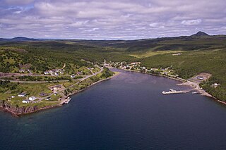
Sunnyside is a town on the Avalon Peninsula in Newfoundland and Labrador, Canada. It is in Division 1 on Bull Arm.

Cuper's Cove, on the southwest shore of Conception Bay on Newfoundland's Avalon Peninsula was an early English settlement in the New World, and the third one after Harbour Grace, Newfoundland (1583) and Jamestown, Virginia (1607) to endure for longer than a year. It was established in 1610 by John Guy on behalf of Bristol's Society of Merchant Venturers, who had been given a charter by King James I of England to establish a colony on the island of Newfoundland. Most of the settlers left in the 1620s, but apparently a few stayed on and the site was continuously inhabited.

<span class="mw-page-title-main">Valentia Island</span> Irish island off the Iveragh Peninsula, County Kerry

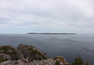
Valentia Island is one of Ireland's most westerly points. It lies off the Iveragh Peninsula in the southwest of County Kerry. It is linked to the mainland by the Maurice O'Neill Memorial Bridge at Portmagee. A car ferry also departs from Reenard Point to Knightstown, the island's main settlement, from April to October. Another, smaller village named Chapeltown sits at roughly the midpoint of the island, three kilometres from the bridge. Valentia Island's permanent population is 658. It is about 11 kilometres long by almost three kilometres wide, making it the fifth-biggest island off the Irish coast.

<span class="mw-page-title-main">Division No. 1, Newfoundland and Labrador</span> Census division in Newfoundland and Labrador, Canada

Division 1, Newfoundland and Labrador is a census division covering the entire Avalon Peninsula including the Isthmus of Avalon of the Canadian province of Newfoundland and Labrador. Like all census divisions in Newfoundland and Labrador, but unlike the census divisions of some other provinces, the division exists only as a statistical division for census data, and is not a political entity.

<span class="mw-page-title-main">Carbonear-Trinity-Bay de Verde</span> Provincial electoral district in Newfoundland and Labrador, Canada

Carbonear-Trinity-Bay de Verde is a provincial electoral district of the House of Assembly of Newfoundland and Labrador, Canada. The district covers the eastern edge of Trinity Bay and the tip of Conception Bay. As of 2011, there are 6,968 eligible voters living within the district.

<span class="mw-page-title-main">Baccalieu Island</span> Lighthouse

Baccalieu Island or Bacalhoo Island is a 5 km2 uninhabited island at the northern extremities of Conception Bay in Subdivision 1G, near the community of Red Head Cove, Newfoundland and Labrador, Canada. It is separated from the island of Newfoundland by Baccalieu Tickle, a small strait and an abundant fishing ground. The island has some trees but is mostly rocky.

Hant's Harbour is an incorporated town located on the east side of Trinity Bay on the Bay de Verde Peninsula in the province of Newfoundland and Labrador, Canada. It has a population of 318 according to the 2021 Canadian census.

Victoria is a landlocked town on the Avalon Peninsula in Newfoundland and Labrador, Canada, located approximately midway on the Bay de Verde Peninsula portion of the Avalon Peninsula.

<span class="mw-page-title-main">Carbonear Island</span> Lighthouse in Newfoundland, Canada

Carbonear Island is a small uninhabited island on the Avalon Peninsula of Newfoundland, Canada. It is located at the mouth of Carbonear harbour. It became a strategic haven for the British settlers of Carbonear fending off the raids by the French and became known for a time as the "Gibraltar of Newfoundland".

Bay de Verde is an incorporated town in Conception Bay on the northern tip of the Bay de Verde Peninsula of Newfoundland and Labrador, Canada. The first recorded inhabitants at Bay de Verde arrived in 1662. Bay de Verde became an incorporated town in 1950.

<span class="mw-page-title-main">Bay Roberts</span> Town in Newfoundland and Labrador, Canada

Bay Roberts is a town located on the north shore of Conception Bay on the northeastern Avalon Peninsula in the province of Newfoundland and Labrador, Canada. The growth of the local economy can be connected to the town's proximity to other major Newfoundland markets, by road and by water.

Heart's Delight-Islington is a town on the south side of Trinity Bay in the Canadian province of Newfoundland and Labrador, located on Newfoundland and Labrador Route 80. The Post Office was established in 1954. The first Postmistress was Maggie Chislett.

<span class="mw-page-title-main">Codroy</span> Community in Newfoundland and Labrador, Canada

Codroy is a community in the Codroy Valley of Newfoundland and Labrador, Canada.

Canada Harbour is an abandoned outport community in Newfoundland and Labrador. It was a French fishing station before 1857, settled by the English in 1860, and abandoned in 1969 during the resettlement program. Canada Harbour currently has 15 dwellings that are used as cottages during the summer months.

New Harbour is a local service district and designated place in the Canadian province of Newfoundland and Labrador. It is on the east shore of Trinity Bay, along Provincial Route 80. Route 80's intersection with Route 73 is inside New Harbour.

Conne was a community in Newfoundland and Labrador, Canada located on the Northern shore of Fortune Bay. It was first reported to be settled in 1836, in the first Census of Newfoundland with sixteen inhabitants. It was a severely isolated settlement, which had no church or school and very little land for growing crops, and it based its existence on the inshore fishery of cod, lobster, salmon and herring.

<span class="mw-page-title-main">Division No. 1, Subdivision G, Newfoundland and Labrador</span> Unorganized territory in Newfoundland and Labrador, Canada

Division No. 1, Subdivision G is an unorganized subdivision on the Avalon Peninsula in Newfoundland and Labrador, Canada. It is in Division 1 and contains the unincorporated communities of Baccalieu Island, Besom Cove, Bradley's Cove, Burnt Point, Caplin Cove, Daniel's Cove, Grates Cove, Gull Island, Job's Cove, Kingston, Long Beach, Lower Island Cove, Low Point, Northern Bay, Ochre Pit Cove, Red Head Cove, Riverhead, Smooth Cove and Western Bay.

<span class="mw-page-title-main">Heart's Content Cable Station</span> Western end of the first permanent trans-oceanic telegraph cable

Heart's Content Cable Station is a former cable landing station located in Heart's Content, Newfoundland and Labrador. It served as the western terminus of the first permanent trans-oceanic submarine telegraph cable, while a sister cable station on Valentia Island, Ireland, served as the eastern terminus. The original cable was first brought ashore in Heart's Content on July 27, 1866, and the station remained in use until it was closed in 1965. The station was designated a Provincial Historic Site in 1974 and is now a museum. On December 20, 2017, it was announced that the Heart's Content Cable Station would be one of eight new sites nominated by the Canadian Government for UNESCO World Heritage Site status.

References

  1. Rowlett, Russ. "Lighthouses of Canada: Southeastern Newfoundland". The Lighthouse Directory. University of North Carolina at Chapel Hill . Retrieved February 9, 2017.
  2. List of Lights, Pub. 110: Greenland, The East Coasts of North and South America (Excluding Continental U.S.A. Except the East Coast of Florida) and the West Indies (PDF). List of Lights . United States National Geospatial-Intelligence Agency. 2016.
  3. "World heritage sites in Canada". Parks Canada. July 2022.
  4. John R. Raynes (1921), Engines and Men , Goodall & Suddick, p. 89, Wikidata   Q115680227
  5. 1 2 3 Jarvis, Dale Gilbert; Rowe, Ted (2020). The Rendell Family of Blacksmiths, Heart's Content, Trinity Bay. Heritage NL Fieldnotes Series. Vol. 9. St. John's, NL: Heritage NL.
  6. Simmons, Lillian (August 7, 2012). "Town has enough history to warrant a heritage district". The Compass. Retrieved July 27, 2020.
  7. "1864 - 65 Directory - Heart's Content". ngb.chebucto.org. Retrieved July 27, 2020.
  8. "HEART'S CONTENT". ngb.chebucto.org. Retrieved July 27, 2020.
  9. Rowe, Ted (July 27, 2020). "The Rendell Forge, Heart's Content". The ICH Blog: Intangible Cultural Heritage, Folklore, and Oral History. Retrieved July 27, 2020.
  10. Lance Corporal Arthur James Rendell (PDF). The Rooms. p. 7.
  11. "Obituary for Leslie James Rendell at Greens Funeral Home & Services". www.greensfuneralservices.ca. Retrieved July 27, 2020.
  12. "Myrtle Marion Rendell | 1931 - 2016 | Obituary". Greens Funeral Home and Services. August 2016.
  13. "Population and dwelling counts: Canada, provinces and territories, census divisions and census subdivisions (municipalities), Newfoundland and Labrador". Statistics Canada. February 9, 2022. Retrieved March 15, 2022.

See also