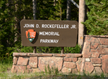
The land was originally part of Teton National Forest and was transferred to the National Park Service from the United States Forest Service to assure an unbroken connection between Grand Teton and Yellowstone National Parks. The parkway road itself extends from the northern end of Grand Teton National Park, through the parkway lands, and then on to West Thumb Geyser Basin in Yellowstone National Park, a distance of 27 miles (43km).
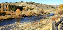
The parkway is a transitional zone in terms of geology with ancient lava beds being found in the north and the granitic rocks of the Teton Range in the south. The Snake River flows through the parkway as it heads south to Jackson Lake and is considered a prime troutfly fishing area. In Grand Teton and Yellowstone, grizzly bears, black bears, moose, elk, bighorn sheep and mule deer can be found there. The Yellowstone fires of 1988 affected the northern sections of the parkway consuming 4,000 acres (1,600ha)). As of 2005, the forest had begun to be rejuvenated and wildlife habitat had actually increased due to better mix of meadow and forest lands. A major relocation project for the Flagg Ranch concession operation (consisting of a lodge, gas station, camp store, cabins and a campground) from along the Snake River to a point higher up and less visible from the road was completed in 2002. Rafting is a popular activity during the summer and guided snowmobile tours use the parkway as a starting point for trips into Yellowstone during the winter.
Grand Teton National Park is an American national park in northwestern Wyoming. At approximately 310,000 acres (1,300 km2), the park includes the major peaks of the 40-mile-long (64 km) Teton Range as well as most of the northern sections of the valley known as Jackson Hole. Grand Teton National Park is only 10 miles (16 km) south of Yellowstone National Park, to which it is connected by the National Park Service–managed John D. Rockefeller Jr. Memorial Parkway. Along with surrounding national forests, these three protected areas constitute the almost 18-million-acre (73,000-square-kilometer) Greater Yellowstone Ecosystem, one of the world's largest intact mid-latitude temperate ecosystems.
The Greater Yellowstone Ecosystem (GYE) is one of the last remaining large, nearly intact ecosystems in the northern temperate zone of the Earth. It is located within the northern Rocky Mountains, in areas of northwestern Wyoming, southwestern Montana, and eastern Idaho, and is about 22 million acres (89,000 km2). Yellowstone National Park and the Yellowstone Caldera 'hotspot' are within it.
Jackson Lake is in Grand Teton National Park in northwestern Wyoming. This natural lake was enlarged by the construction of the Jackson Lake Dam, which was originally built in 1911, enlarged in 1916 and rebuilt by 1989. As part of the Minidoka Project the top 33 ft (10 m) of the lake is used by farmers in Idaho for irrigation purposes under water rights legislation that was enacted prior to the establishment of Grand Teton National Park. The lake is the remnant of large glacial gouging from the neighboring Teton Range to the west and the Yellowstone Plateau to the north. The lake is primarily fed by the Snake River, which flows in from the north, and empties at Jackson Lake Dam. Jackson Lake is one of the largest high altitude lakes in the United States, at an elevation of 6,772 ft (2,064 m) above sea level. The lake is up to 15 mi (24 km) long, 7 mi (11 km) wide and 438 ft (134 m) deep. The water of the lake averages below 60 °F (16 °C), even during the summer.
U.S. Route 89 is a north–south United States Numbered Highway with two sections, and one former section. The southern section runs for 848 miles (1,365 km) from Flagstaff, Arizona, to the southern entrance of Yellowstone National Park. The northern section runs for 404 miles (650 km) from the northern entrance of Yellowstone National Park in Montana, ending at the Canadian border. Unnumbered roads through Yellowstone connect the two sections. Before 1992, US 89 was a Canada–Mexico, border-to-border highway that ended at Nogales, Arizona, on its southern end.
U.S. Route 191 is a spur of U.S. Route 91 that has two segments. The southern segment runs for 1,102 miles (1,773 km) from Douglas, Arizona on the Mexican border to the southern part of Yellowstone National Park. The northern segment runs for 442 miles (711 km) from the northern part of Yellowstone National Park to Loring, Montana, at the Canada–US border. Unnumbered roads within Yellowstone National Park connect the two segments. The highway passes through the states of Arizona, Utah, Wyoming, and Montana.
Bridger–Teton National Forest is located in western Wyoming, United States. The forest consists of 3.4 million acres, making it the third largest National Forest outside Alaska. The forest stretches from Yellowstone National Park, along the eastern boundary of Grand Teton National Park and from there rides along the western slope of the Continental Divide to the southern end of the Wind River Range. The forest also extends southward encompassing the Salt River Range and Wyoming Range mountains near the Idaho border.
Caribou–Targhee National Forest is located in the states of Idaho and Wyoming, with a small section in Utah in the United States. The forest is broken into several separate sections and extends over 2.63 million acres (10,600 km2). To the east the forest borders Yellowstone National Park, Grand Teton National Park and Bridger–Teton National Forest. Most of the forest is a part of the 20-million-acre (81,000 km2) Greater Yellowstone Ecosystem.
Teton Wilderness is located in Wyoming, United States. Created in 1964, the Teton Wilderness is located within Bridger-Teton National Forest and consists of 585,238 acres (2,370 km2). The wilderness is bordered on the north by Yellowstone National Park and to the west by Grand Teton National Park and the John D. Rockefeller Jr. Memorial Parkway. The Washakie Wilderness is to the east and the remainder of Bridger-Teton National Forest is to the south. The Teton Wilderness is a part of the 20 million-acre (81,000 km2) Greater Yellowstone Ecosystem. Among many other features, Teton Wilderness is notable for having the most remote location of any place in the contiguous 48 states of the US. This location occurs very close to Bridger Lake, near the confluence of the Thorofare and Yellowstone Rivers, not far from the USFS Hawk's Rest Ranger Station.
The Winegar Hole Wilderness is located in the U.S. state of Wyoming. Designated wilderness by Congress in 1984, the wilderness is within Caribou-Targhee National Forest and borders Yellowstone National Park. The wilderness was created to further protect what is considered to be prime grizzly bear habitat. The wilderness is an integral part of the Greater Yellowstone Ecosystem.
The National Elk Refuge is a Wildlife Refuge located in Jackson Hole in the U.S. state of Wyoming. It was created in 1912 to protect habitat and provide sanctuary for one of the largest elk herds. With a total of 24,700 acres (10,000 ha), the refuge borders the town of Jackson, Wyoming on the southwest, Bridger-Teton National Forest on the east and Grand Teton National Park on the north. It is home to an average of 7,500 elk each winter. The refuge is managed by the U.S. Fish and Wildlife Service, an agency of the U.S. Department of the Interior.
Moose is an unincorporated community in Teton County, Wyoming, in the Jackson Hole valley. It has a US Post Office, with the zip code of 83012. The town is located within Grand Teton National Park along the banks of the Snake River. It is populated mostly by families with inholdings within the borders of the park.
Moran is an unincorporated village in south central Teton County, Wyoming, United States: as the community has had two different names, the Board on Geographic Names officially ruled in favor of "Moran" in 1970. It lies in Grand Teton National Park, 29 miles northeast of the city of Jackson, the county seat of Teton County, just northwest by side road of the intersection of U.S. Routes 26, 89, 191 and 287. Its elevation is 6,749 feet (2,057 m) and includes one of the principal entrance-fee collection stations for the Park. Moran also has the post office serving ZIP code of 83013, and a public elementary school; and no other services or businesses.
The Laurance S. Rockefeller (LSR) Preserve is a 1,106 acres (448 ha) refuge within Grand Teton National Park on the southern end of Phelps Lake, Wyoming. The site was originally known as the JY Ranch, a dude ranch. Starting in 1927, John D. Rockefeller Jr. purchased much of the land in Jackson Hole for the creation of Jackson Hole National Monument and the expansion of Grand Teton National Park. But he retained the 3,100-acre (1,300 ha) JY Ranch as a family retreat. Over the years the family gave most of the ranch to the national park. Laurance S. Rockefeller donated the final parcel in 2001. The donation came with special preservation and maintenance restrictions, with the vision that the preserve remain a place where visitors can experience a spiritual and emotional connection to the beauty of the lake and the Teton Range.
Lake of the Woods is a mountain lake in Wyoming, located upstream from Grassy Lake along the Ashton-Flagg Ranch road.
Menor's Ferry was a river ferry that crossed the Snake River near the present-day Moose, Wyoming, United States. The site was homesteaded by Bill Menor in 1892-94, choosing a location where the river flowed in a single channel, rather than the braided stream that characterizes its course in most of Jackson Hole. During the 1890s it was the only homestead west of the river. Menor's homestead included a five-room cabin, a barn, a store, sheds and an icehouse on 148 acres (60 ha), irrigated by a ditch from Cottonwood Creek and at times supplemented by water raised from the Snake River by a waterwheel. Menor operated the ferry until 1918, selling to Maude Noble, who continued operations until 1927, when a bridge was built at Moose.
The Manges Cabin in Grand Teton National Park, also known as the Old Elbo Ranch Homestead Cabin, Mangus Cabin and the Taggart Creek Barn, was built in 1911 by James Manges. Manges was the second settler on the west side of the Snake River after Bill Menor, setting up a homestead near Taggart Creek. James Manges arrived in Jackson Hole in 1910, where he cut wood for Charles or William Wort. Manges' cabin is stated to have been the first two-story structure in the northern part of the valley. A root cellar was excavated beneath. The log and frame structure features wide eaves to keep the winter snow away from the walls. It was heated in winter by a single stove, with one room on each level.
The following articles relate to the history, geography, geology, flora, fauna, structures and recreation in Yellowstone National Park.
Flagg Ranch is a privately operated resort located in the John D. Rockefeller Jr. Memorial Parkway corridor between Yellowstone National Park and Grand Teton National Park in northwestern Wyoming. The location was initially occupied in the 1890s by the Snake River Military Station, part of a network of U.S. Army outposts for patrol and management of Yellowstone National Park in its early years under military administration. The outpost operated under Army control until 1906, when the land to the south of the Yellowstone boundary were turned over to the U.S. Forest Service, becoming Teton National Forest in 1908. The station became a stopping point for travelers between Jackson, Wyoming and Yellowstone, easily identifiable by the flags that flew over it.
The following articles relate to the history, geography, geology, flora, fauna, structures and recreation in Grand Teton National Park.
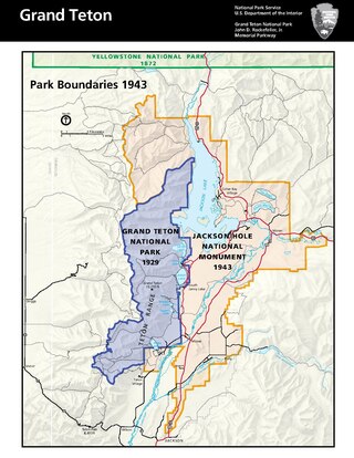
On March 15, 1943, Franklin D. Roosevelt signed Presidential Proclamation 2578 establishing a large swath of land east of the Teton National Park as a national monument. The area of land covered 221,610 acres (89,680 ha). The majority of the land was National Forest, but 32,117 acres (12,997 ha) of the monument were donated by John D. Rockefeller, Jr., and 17,000 acres (6,900 ha) were privately owned ranches. This proclamation incited a controversy in Teton County that caused immediate pushback from western congressmen who saw the act as a violation of state sovereignty.
This page is based on this Wikipedia article Text is available under the CC BY-SA 4.0 license; additional terms may apply. Images, videos and audio are available under their respective licenses.