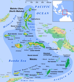
The Maluku Islands or the Moluccas are an archipelago in eastern Indonesia. Tectonically they are located on the Halmahera Plate within the Molucca Sea Collision Zone. Geographically they are located east of Sulawesi, west of New Guinea, and north and east of Timor.

Seram is the largest and main island of Maluku province of Indonesia, despite Ambon Island's historical importance. It is located just north of the smaller Ambon Island and a few other surrounding islands, such as Haruku, Geser, Nusalaut, Banda and Saparua.

Saparua is an island east of Ambon Island in the Indonesian province of Maluku; the island of Haruku lies between Saparua and Ambon. The main port is in the south at Kota Saparua. The island of Maolana is located near its southwestern side and Nusa Laut off its southeastern tip.

Maluku is a province of Indonesia. It comprises the central and southern regions of the Maluku Islands. The main city and capital of Maluku province is Ambon on the small Ambon Island. The land area is 62,946 km2, and the total population of this province at the 2010 census results amounted to 1,533,506 people; the latest official estimate is 1,768,500. Maluku is located in Eastern Indonesia. It is directly adjacent to North Maluku and West Papua in the north, Central Sulawesi, and Southeast Sulawesi in the west, Banda Sea, East Timor and East Nusa Tenggara in the south and Arafura Sea and Papua in the east.
Paperu, Indonesia, is a village on the island of Saparua, which is a part of the Ambon island group in the Maluku Islands.

Thomas Matulessy, also known as Kapitan Pattimura or simply Pattimura, was an Ambonese soldier and National Hero of Maluku.
The Piru Bay languages are a group of twenty Malayo-Polynesian languages, spoken on Ambon Island and around Piru Bay on the island of Seram. None of the languages have more than about twenty thousand speakers, and several are endangered with extinction.

Central Maluku Regency is a regency of Maluku, Indonesia. The Regency covers an area of 11,595.57 km2, and had a population of 361,698 at the 2010 Census, and 369,315 at the 2015 Census. The principal town lies at Masohi, on Seram Island. The regency (kebupaten) is composed of the central part of the island of Seram, the Banda Islands, and the Lease Islands, together with those parts of Ambon Island which are outside the City of Ambon.
The Kingdom of Iha was an Islamic kingdom located in Saparua island, Maluku. Around the Dutch colonial period, there are exist two well-known kingdoms in Saparua Island, Iha and Honimoa. Both are quite influential Islamic empire was known as sapanolua. This means two boat or two boats. It means Saparua island has two large peninsula thereon ruling two kings with a vast land. While the southeast peninsula controlled by the King of Honimoa with his kingdom, the north peninsula is the regional power of the Kingdom of Iha. The Kingdom of Iha involved in a series of struggle against the Dutch colonization in Maluku that later profound as Iha War (1632-1651) which resulted in a loss of some areas of this kingdom as well as its citizens that impact to later deterioration.
Masohi is a coastal town on the Indonesian island of Seram. It is the capital of the Central Maluku Regency. It was the site of a detention camp for political prisoners in the 1970s. The headquarters of Manusela National Park is located in Masohi.

Haruku Island is an island in Central Maluku Regency, Maluku Province, Indonesia - lying east of Ambon Island, off the southern coast of Seram and just west of Saparua. It is administered as a single district, Kecamatan Pulau Haruku, with a 2010 census population of 24,170. The inhabitants on Haruku speak the Haruku language, as well as Indonesian and Ambonese Malay.
Nusa Laut is the smallest inhabited island in the Lease Islands group east of Ambon, in Indonesia's Maluku province. It lies just off the south-western corner of Saparua island, separated from it by a deep channel. The island's coasts are fringed by a drying reef.
Haria is one of the 17 villages on the island of Saparua, Maluku, Indonesia.

Manipa Island is an island in West Seram Regency, Maluku Province, Indonesia. It is located 8 km off the western coast of Kelang at the western end of Seram Island and 25 km off the western coast of Buru. The inhabitants speak the Manipa language, as well as Indonesian and Ambonese Malay.

Fort Duurstede is a 17th-century colonial Dutch fort in Saparua, Indonesia The fort originally protected Saparoea village. A navigation guide from 1878 advises: "There is good anchorage near this fort in the westerly monsoon in about 12 fathoms."
Sapalewa River, also Sapolewa, is a river of Seram Island, Maluku province, Indonesia, about 2400 km northeast of the capital Jakarta.
Eti River is a river of Seram Island, Maluku province, Indonesia, about 2400 km northeast of the capital Jakarta. It flows into the sea on the southwest side of the island, a few kilometres south of the town of Piru, West Seram Regency.
Tala River is a river of western Seram Island, Maluku province, Indonesia, about 2400 km northeast of the capital Jakarta.
Johanis Hermanus Manuhutu (born in Haria, Saparua on 9 April 1908 - died in Haria, Saparua, 22 August 1984 was a South Moluccan civil servant in the Dutch East Indies and the first president of the Republic of South Maluku in 1950.

