List of mountains and hills


Over 1000m
| Mountain or hill | Height | Island | Notes |
|---|---|---|---|
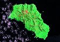
| Queen Mary's Peak | 2,062 metres (6,765 ft) | Tristan da Cunha | an Ultra prominent peak tallest in whole overseas territory and on the island |
| Mount Olav | 1,969 metres (6,460 ft) | Tristan da Cunha |
750m to 1000m
| Mountain or hill | Height | Island | Notes |
|---|---|---|---|
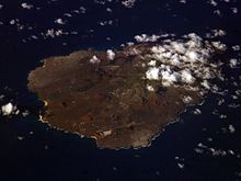
| Edinburgh Peak | 910 metres (2,990 ft) | Gough Island (Tristan da Cunha) | tallest on the island |
| Expedition Peak | 909 metres (2,982 ft) | Gough Island | |
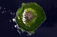
| Green Mountain "The Peak" | 859 metres (2,818 ft) | Ascension Island | tallest on the island |
| Centre Rowett | 836 metres (2,743 ft) | Gough Island | highest of the Mount Rowett peaks |
| Diana's Peak | 818 metres (2,684 ft) | Saint Helena | tallest on the island |
| Nigel's Cap | 811 metres (2,661 ft) | Gough Island | |
| North Rowett | 808 metres (2,651 ft) | Gough Island | one of the Mount Rowett peaks |
| West Rowett | 805 metres (2,641 ft) | Gough Island | one of the Mount Rowett peaks |
| High Peak | 798 metres (2,618 ft) | Saint Helena | |
| False Peak | 757 metres (2,484 ft) | Gough Island |
500m to 750m
| Mountain or hill | Height | Island | Notes |
|---|---|---|---|
| Sandy Bay Ridge | 747 metres (2,451 ft) | Saint Helena | |
| Sea-hen Crag | 710 metres (2,330 ft) | Gough Island | |
| High Hill | 707 metres (2,320 ft) | Saint Helena | |
| White Point | 694 metres (2,277 ft) | Saint Helena | |
| Hag's Tooth | 692 metres (2,270 ft) | Gough Island | |
| Hooper's Ridge | 691 metres (2,267 ft) | Saint Helena | |
| Flagstaff Hill | 688 metres (2,257 ft) | Saint Helena | |
| Halley's Mount | 680 metres (2,230 ft) | Saint Helena | named for Edmond Halley |
| Tavistock Crag | 640 metres (2,100 ft) | Gough Island | |
| The Saddle | 639 metres (2,096 ft) | Saint Helena | |
| Triple Peak | 634 metres (2,080 ft) | Gough Island | |
| The Haystack | 616 metres (2,021 ft) | Saint Helena | highest point of The Barn |
| Weather Post | 608 metres (1,995 ft) | Ascension Island | |
| Long Range | 588 metres (1,929 ft) | Saint Helena | |
| Mount Argus | 587 metres (1,926 ft) | Gough Island | |
| High Knoll | 584 metres (1,916 ft) | Saint Helena | |
| Joan Hill | 579 metres (1,900 ft) | Saint Helena | |
| Blue Point | 573 metres (1,880 ft) | Saint Helena | |
| Green Hill | 570 metres (1,870 ft) | Gough Island | |
| Stone Top Ridge | 566 metres (1,857 ft) | Saint Helena | height given near "The Bellstone" |
| Swale's Fell | 561 metres (1,841 ft) | Inaccessible Island (Tristan da Cunha) | tallest on the island; on Gony Ridge |
| Red Hill | 546 metres (1,791 ft) | Ascension Island | ("The Ring") |
| White Hill | 543 metres (1,781 ft) | Saint Helena | |
| Devil's Ashpit | 536 metres (1,759 ft) | Ascension Island | location of NASA Challenger Centre |
| Piccolo Hill | 529 metres (1,736 ft) | Saint Helena | |
| White Hill | 525 metres (1,722 ft) | Ascension Island | |
| Boulder Hill | 510 metres (1,670 ft) | Inaccessible Island | on Gony Ridge |
250m to 500m
| Mountain or hill | Height | Island | Notes |
|---|---|---|---|
| Great Stone Top | 494 metres (1,621 ft) | Saint Helena | |
| Lot's Wife | 462 metres (1,516 ft) | Saint Helena | (also a rock off the north coast of Gough Island) |
| Lot | 454 metres (1,490 ft) | Saint Helena | |
| Cairn Peak | 323 metres (1,060 ft) | Inaccessible Island | |
| Sisters Peak | 445 metres (1,460 ft) | Ascension Island | |
| Boxwood Hill | 434 metres (1,424 ft) | Saint Helena | |
| Sandy Bay Barn | 431 metres (1,414 ft) | Saint Helena | |
| Rupert's Hill | 405 metres (1,329 ft) | Saint Helena | |
| Horse Point | 403 metres (1,322 ft) | Saint Helena | |
| Round Hill | 388 metres (1,273 ft) | Inaccessible Island | |
| Denstone Hill | 384 metres (1,260 ft) | Inaccessible Island | |
| High Ridge | 378 metres (1,240 ft) | Nightingale Island (Tristan da Cunha) | tallest on the island |
| Spoon Crater | 364 metres (1,194 ft) | Ascension Island | |
| Traveller's Hill | 357 metres (1,171 ft) | Ascension Island | also name of nearby RAF base |
| The Fid | 355 metres (1,165 ft) | Gough Island | |
| South East Crater | 349 metres (1,145 ft) | Ascension Island | |
| Joe's Hill | 330 metres (1,080 ft) | Inaccessible Island | |
| Lady Hill | 329 metres (1,079 ft) | Ascension Island | |
| South Hill | 323 metres (1,060 ft) | Inaccessible Island | |
| 300 metres (980 ft) | Nightingale Island (Tristan da Cunha) | ||
| Sugar Loaf Hill | 272 metres (892 ft) | Saint Helena | |
| Ladder Hill | 268 metres (879 ft) | Saint Helena | |
| Cross Hill | 263 metres (863 ft) | Ascension Island |
50m to 250m
| Mountain or hill | Height | Island | Notes |
|---|---|---|---|
| Bears Back | 240 metres (790 ft) | Ascension Island | |
| Dark Slope Crater | 234 metres (768 ft) | Ascension Island | |
| Broken Tooth | 228 metres (748 ft) | Ascension Island | ("East Crater") |
| South Gannet Hill | 228 metres (748 ft) | Ascension Island | |
| Goat Pound Ridge | 227 metres (745 ft) | Saint Helena | |
| Richmond Hill | 210 metres (690 ft) | Gough Island | SE of the island, near the Meteorological Station |
| Pig Beach Hill | 207 metres (679 ft) | Inaccessible Island | |
| Egg Island | 79 metres (259 ft) | Saint Helena |
Other hills and hill features
NB: Many of these hills and features are over 200m.

| Mountain or hill | Height | Island | Notes |
|---|---|---|---|
| Cat Hill | Ascension Island | location of the main US base | |
| Letter Box | Ascension Island | ||
| Devil's Riding School | Ascension Island | a crater | |
| Devil's Cauldron | Ascension Island | a crater, near Weather Post | |
| Round Hill | Ascension Island | ||
| Booby Hill | Ascension Island | ||
| Holland's Crater | Ascension Island | ||
| Dune Hills | Inaccessible Island | ||
| Long Ridge | Inaccessible Island | ||
| Little Stone Top | Saint Helena | ||
| Mount Vesey | Saint Helena | ||
| Drummond's Point | Saint Helena | ||
| Munden's Mount | Saint Helena | ||
| Green Hill | Saint Helena | ||
| Cuckold's Point | Saint Helena | near Diana's Peak | |
| Mount Actaeon | Saint Helena | near Diana's Peak | |
| Mount Ross | Saint Helena | ||
| Bunker's Hill | Saint Helena | ||
| Silver Hill | Saint Helena | ||
| Blue Hill | Saint Helena | ||
| The Saddle | Saint Helena | ||
| Beach Hill | Saint Helena | ||
| Horse Point | Saint Helena | ||
| Turk's Cap | Saint Helena | ||
| Thompson's Hill | Saint Helena | ||
| King & Queen Rocks | Saint Helena | ||
| Horse Ridge | Saint Helena | ||
| Dry Gut Hill | Saint Helena | ||
| Botley's Point | Saint Helena | ||
| Rock Mount | Saint Helena | ||
| Sheep Knoll | Saint Helena | ||
| Powell's Valley Hill | Saint Helena | ||
| Brown's Hill | Saint Helena | ||
| Bonfire Ridge | Saint Helena | ||
| Woodland's Hill | Saint Helena | ||
| Isaac's Hill | Saint Helena | ||
| Round Hill | Tristan da Cunha | ||
| Cave Gulch Hill | Tristan da Cunha | ||
| Red Hill | Tristan da Cunha |