
The geography of Mozambique consists mostly of coastal lowlands with uplands in its center and high plateaus in the northwest. There are also mountains in the western portion. The country is located on the east coast of southern Africa, directly west of the island of Madagascar. Mozambique has a tropical climate with two seasons, a wet season from October to March and a dry season from April to September.

Portuguese Mozambique or Portuguese East Africa were the common terms by which Mozambique was designated during the period in which it was a Portuguese colony. Portuguese Mozambique originally constituted a string of Portuguese possessions along the south-east African coast, and later became a unified colony, which now forms the Republic of Mozambique.

Sofala is a province of Mozambique. It has a population of 2,259,248. Beira is the capital of the province, named for the ruined port of Sofala which is 35 kilometres (22 mi) to the south.

Gaza is a province of Mozambique. It has an area of 75,709 km2 and a population of 1,422,460, which is the least populous of all the provinces of Mozambique.

A transboundary protected area (TBPA) is an ecological protected area that spans boundaries of more than one country or sub-national entity. Such areas are also known as transfrontier conservation areas (TFCAs) or peace parks.
The Lubombo Transfrontier Conservation Area was born out of the Peace Park Foundation’s vision to establish a network of transfrontier conservation areas in southern Africa. It straddles the border between South Africa’s KwaZulu-Natal province, southern Mozambique, and Eswatini.

Great Limpopo Transfrontier Park is a 35,000 km² peace park that is in the process of being formed. It will link the Limpopo National Park in Mozambique, Kruger National Park in South Africa, Gonarezhou National Park, Manjinji Pan Sanctuary and Malipati Safari Area in Zimbabwe, as well as the area between Kruger and Gonarezhou, the Sengwe communal land in Zimbabwe and the Makuleke region in South Africa.
The Limpopo National Park was born when the status of Coutada 16 Wildlife Utilisation Area in Gaza Province, Mozambique, was changed from a hunting concession to a protected area. It forms part of the Great Limpopo Transfrontier Park with the Kruger National Park in South Africa and the Gonarezhou National Park in Zimbabwe.

The wildlife of Mozambique consists of the flora and fauna of this country in southeastern Africa. Mozambique has a range of different habitat types and an ecologically rich and diverse wildlife. This includes 236 species of mammal, 740 species of bird and 5,692 species of vascular plant. The Maputaland-Pondoland-Albany hotspot, with significantly high levels of biodiversity, stretches from the southern tip of Mozambique into northeastern South Africa.

Chigubo District is a district of Gaza Province in south-western Mozambique. The administrative center of the district is Dindiza. The district is located in the east of the province, and borders with Massangena District in the north, Mabote and Funhalouro Districts of Inhambane Province in the east, Chibuto District in the south, Guijá District in the southwest, Mabalane District in the west, and with Chicualacuala District in the northwest. The area of the district is 14,864 square kilometres (5,739 sq mi). It has a population of 20,685 (2007).

Sussundenga District is a district of Manica Province in western Mozambique. The principal town is Sussundenga. The district is located in the center of the province, and borders with Manica District in the north, Gondola District in the northeast, Buzi District of Sofala Province in the east, Chibabava District of Sofala Province in the southeast, Mossurize District in the south, and with Zimbabwe in the west. The area of the district is 7,057 square kilometres (2,725 sq mi). It has a population of 129,851 as of 2007.
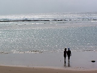
The tourism assets of Mozambique include the country's natural environment, wildlife, and cultural heritage, which provide opportunities for beach, cultural, and eco-tourism.

The Southern Zanzibar–Inhambane coastal forest mosaic, also known as the Southern Swahili coastal forests and woodlands, is a tropical moist broadleaf forest ecoregion of eastern Africa. It is a southern variation of Northern Zanzibar-Inhambane coastal forest mosaic. The ecoregion supports habitats of forest, savanna and swamps. The southern portion of the ecoregion is not as well studied due to the 1977-1992 civil war in Mozambique.

Banhine National Park is a protected area in northern Gaza Province, Mozambique. The park was established on 26 June 1973. In 2013 the limits of Park were updated to better reflect the realities on the ground, particularly the human presence in the area.
The Zinave National Park is a protected area in Mabote District of Inhambane Province, Mozambique, created by decree on 26 June 1973.

The Zambezian and mopane woodlands is a tropical and subtropical grasslands, savannas, and shrublands ecoregion of southeastern Africa.
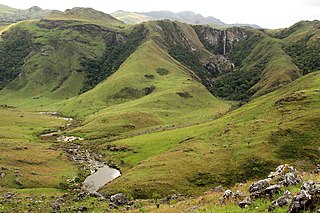
The Chimanimani Mountains are a mountain range on the border of Zimbabwe and Mozambique. The mountains are in the southern portion of the Eastern Highlands, or Manica Highlands, a belt of highlands that extend north and south along the international border, between the Zambezi and Save rivers.
The Peace Park Foundation, founded in 1997 by Dr Anton Rupert, President Nelson Mandela and Prince Bernhard of the Netherlands, is an organization that aims to re-establish, renew and conserve large ecosystems in Africa, transcending man-made boundaries by creating regionally integrated and sustainably managed networks of Transfrontier Conservation Areas (TFCAs). Peace Parks Foundation has been involved in the establishment and development of ten of the 18 TFCAs found throughout southern Africa, all of which are in various stages of development. The establishment of each TFCA, or peace park, is complex and far-reaching, and involves several phases of activity, which can take many years to achieve.

Chimanimani National Park is a protected area in Manica Province of Mozambique. It is located in the Chimanimani Mountains on the border with Zimbabwe. Together with Zimbabwe's Chimanimani National Park it forms the Chimanimani Transfrontier Park. It was designated a national reserve in 2003. In 2020 it was designated a national park.
The following is a timeline of events during the Mozambican Civil War as well as subsequent RENAMO insurgency (2013–2021).
