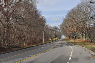
March Route of Rochambeau's Army: Manship Road-Barstow Road | |
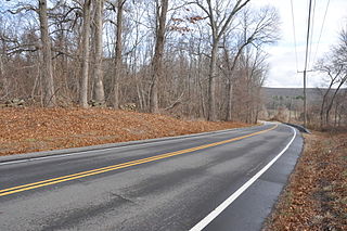
Manship Road and stone wall, in 2016 | |
  | |
| Location | Manship Rd., Barstow Rd. from jct. with Manship Rd. to Westminster Rd., Canterbury, Connecticut |
|---|---|
| Coordinates | 41°42′7″N72°0′13″W / 41.70194°N 72.00361°W Coordinates: 41°42′7″N72°0′13″W / 41.70194°N 72.00361°W |
| Area | 2 acres (0.81 ha) |
| MPS | Rochambeau's Army in Connecticut, 1780-1782 MPS |
| NRHP reference # | 02001678 [1] |
| Significant dates | |
| Dates of significance | 1781, 1782 |
| Added to NRHP | January 8, 2003 |

March Route of Rochambeau's Army: Manship Road-Barstow Road is a historic site in Canterbury, Connecticut that was listed on the National Register of Historic Places in 2003, for its evocation of the march route French commander Rochambeau's troops in 1781 and in 1782.

Canterbury is a town in Windham County, Connecticut, United States. The population was 5,234 at the 2010 census.

The National Register of Historic Places (NRHP) is the United States federal government's official list of districts, sites, buildings, structures, and objects deemed worthy of preservation for their historical significance. A property listed in the National Register, or located within a National Register Historic District, may qualify for tax incentives derived from the total value of expenses incurred preserving the property.
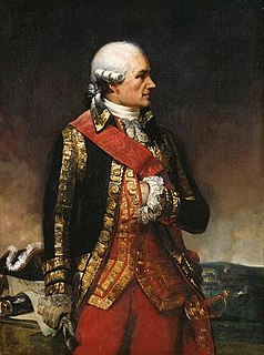
Marshal Jean-Baptiste Donatien de Vimeur, comte de Rochambeau was a French nobleman and general who played a major role in helping the Thirteen Colonies win independence during the American Revolution. During this time, he served as commander-in-chief of the French Expeditionary Force that embarked from France in order to help the American Continental Army fight against British forces.


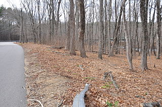
It is significant as a preserved section of the march route which, in this area, is followed by what is now Connecticut Route 14. This section, however, is a bypassed loop of road, cut off by a road realignment in the 1930s, and therefore without traffic and not modernized. The section is approximately 1,400 feet of bypassed loop of road, on the north side of the main road, along Manship Road and Barstow Road, starting from a junction of the loop with Manship Road and running to Westminster Road. It is paved road about 20 feet wide, plus a margin to stone walls lining the road. The designated area is about 50 to 55 feet wide, extending to the walls. The National Register nomination of 2001 includes six photos of narrow roadway, stone walls, and the one house along this section. The house is itself historical, dating from about the 1840s, and adds rather than detracts from the historical feel. [2]

Connecticut Route 14 is one of several secondary routes from eastern Connecticut into Rhode Island. It runs from the Willimantic section of the town of Windham to the Rhode Island state line in Sterling.
Rochambeau's troops marched through here in June, 1781, and found the road along this general area to be the most difficult along their whole journey. Although the road has been paved, the visual appearance is still evocative of passage of troops. [2]
Other preserved sections of the route nearby include March Route of Rochambeau's Army: Old Canterbury Road (about 2 miles (3.2 km) to the east, along Route 14 through Canterbury then straight on 14A, Canterbury Road) and March Route of Rochambeau's Army: Palmer Road (an approximately 2,000-foot (610 m) stretch about 3 miles (4.8 km) to the west along Route 14).

March Route of Rochambeau's Army: Old Canterbury Road is a historic site in Plainfield, Connecticut along the 1781 and/or 1782 march routes of Rochambeau's army. It includes a stretch of what is now Old Canterbury Road and a stretch of Canterbury Road whose environs evoke the period of the Rochambeau army's march. It is a 2-acre (0.81 ha) site that was listed on the National Register of Historic Places in 2003.
The March Route of Rochambeau's Army: Palmer Road is a linear historic district encompassing a portion of Connecticut Route 14 in eastern Scotland, Connecticut. It was listed on the National Register of Historic Places in 2003 as an evocative surviving element of the march route of the French Army commanded by Rochambeau during the American Revolutionary War in 1781 and 1782.
Multiple other properties whose association with Rochambeau's route is known were also considered for listing on the National Register in a 2001 study. [3]