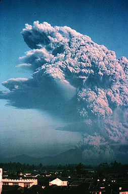
Mount Galunggung is an active stratovolcano in West Java, Indonesia, around 80 km (50 mi) southeast of the West Java provincial capital, Bandung. Mount Galunggung is part of the Sunda Arc extending through Sumatra, Java and the Lesser Sunda Islands, which has resulted from the subduction of the Australian Plate beneath the Eurasian Plate.

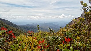
Mount Kerinci, also spelled Kerintji, is an active stratovolcano and the highest mountain in Sumatra, Indonesia. At 12,484 ft (3,805 m) above sea level, it provides Sumatra with the fifth-highest maximum elevation of any island in the world. It is surrounded by the lush forest of Kerinci Seblat National Park, home to several endangered species including the Sumatran tiger. Mount Kerinci is ranked 32nd by topographic isolation.

The Bukit Barisan or the Barisan Mountains are a mountain range on the western side of Sumatra, Indonesia, covering nearly 1,700 km (1,050 mi) from the north to the south of the island. The Bukit Barisan range consists primarily of volcanoes shrouded in dense jungle cover, including Sumatran tropical pine forests on the higher slopes. The highest peak of the range is Mount Kerinci at 3,800 metres (12,467 ft). The Bukit Barisan Selatan National Park is situated towards the southern end of the range in Liwa, Indonesia.

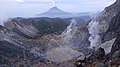
Tangkuban Perahu is a stratovolcano in Lembang, West Bandung Regency. It erupted in 1826, 1829, 1842, 1846, 1896, 1910, 1926, 1929, 1952, 1957, 1961, 1965, 1967, 1969, 1983, 2013 and 2019. It is a popular tourist attraction where tourists hike or ride to the edge of the crater to view the hot water springs and boiling mud up close, and buy eggs cooked on the hot surface. Together with Mount Burangrang and Bukit Tunggul, it is a remnant of the ancient Mount Sunda after the plinian eruption caused the Caldera to collapse.

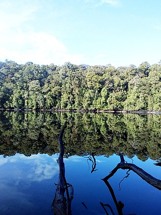
Mount Rinjani is an active volcano in Indonesia on the island of Lombok. Administratively the mountain is in the Regency of North Lombok, West Nusa Tenggara. It rises to 3,726 metres (12,224 ft), making it the second highest volcano in Indonesia. It is also the highest point in the Indonesian province of West Nusa Tenggara. Adjacent to the volcano is a 6-by-8.5-kilometre caldera, which is filled partially by the crater lake known as Segara Anak or Anak Laut, due to the color of its water, as blue as the sea (laut). This lake is approximately 2,000 metres (6,600 ft) above sea level and estimated to be about 200 metres (660 ft) deep; the caldera also contains hot springs. The lake and mountain are sacred to the Sasak people and Hindus, and are the site of religious rituals. UNESCO made Mount Rinjani Caldera a part of the Global Geoparks Network in April 2018. Its catastrophic eruption in 1257 was the largest volcanic eruption in the last 2000 years.
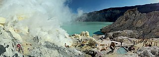
The Ijen volcano complex is a group of composite volcanoes located on the border between Banyuwangi Regency and Bondowoso Regency of East Java, Indonesia. It is known for its blue fire, acidic crater lake, and labour-intensive sulfur mining.
Mount Talang (2,597 m [8,520 ft]) is an active stratovolcano in West Sumatra, Indonesia. Talang has two crater lakes on its flanks, the largest of which is 1 by 2 kilometres wide and is called Lake Talang.
The Tropical Rainforest Heritage of Sumatra site was inscribed as a UNESCO World Heritage Site in 2004. It comprises three Indonesian national parks on the island of Sumatra: Gunung Leuser National Park, Kerinci Seblat National Park and the Bukit Barisan Selatan National Park. The site is listed under Criteria vii - outstanding scenic beauty; ix- an outstanding example representing significant on-going ecological and biological processes; and x- contains the most important and significant natural habitats for in-situ conservation. The Tropical Rainforest Heritage of Sumatra has been placed on the Danger List since 2011 to help overcome threats posed by poaching, illegal logging, agricultural encroachment, and plans to build roads through the site.

The Karo people are a people of the Tanah Karo in North Sumatra, Indonesia. The Karo lands consist of Karo Regency, plus neighboring areas in East Aceh Regency, Langkat Regency, Dairi Regency, Simalungun Regency, and Deli Serdang Regency. In addition, the cities of Binjai and Medan, both bordered by Deli Serdang Regency, contain significant Karo populations, particularly in the Padang Bulan area of Medan. The town of Sibolangit, Deli Serdang Regency in the foothills of the road from Medan to Berastagi is also a significant Karo town.
Mount Sirung is an active volcano complex volcano located on Pantar Island in the Alor archipelago of the eastern Indonesian province of Nusa Tenggara Timor. The crater rim can be reached by an easy hike from the village of Kakamauta. Inside the crater is a large sulphurous crater lake and several active steam vents. The last major eruption occurred 1970, and regular gas and clastic eruptions have occurred since 2004. A small eruption beginning May 12, 2012 triggered an evacuation of an area within a 1.5 km radius of the caldera.

Mount Sinabung is a Pleistocene-to-Holocene stratovolcano of andesite and dacite in the Karo plateau of Karo Regency, North Sumatra, Indonesia, 40 kilometres (25 mi) from the Lake Toba supervolcano. Many old lava flows are on its flanks and the last known eruption, before recent times, occurred 1200 years before present, between 740 - 880 CE. Solfataric activities were last observed at the summit in 1912; recent documented events include an eruption in the early hours of 29 August 2010 and eruptions in September and November 2013, January, February and October 2014. The volcano has recently claimed the life of at least 23 people in a number of events since 2014. Between 2013 and 2014, the alert for a major event was increased with no significant activity. On 2 June 2015, the alert was again increased, and on 26 June 2015, at least 10,000 people were evacuated, fearing a major eruption. The long eruption of Mount Sinabung is similar to that of Mount Unzen in Japan, which erupted for five years after lying dormant for 400 years. A major eruption began on 10 August 2020.

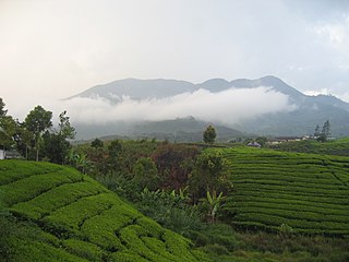
Mount Papandayan is a complex stratovolcano, located in Garut Regency, to the southeast of the city of Bandung in West Java, Indonesia. It is about 15 kilometres (9.3 mi) to the southwest of the town of Garut. At the summit, there are four large craters which contain active fumarole fields. An eruption in 1772 caused the northeast flank to collapse producing a catastrophic debris avalanche that destroyed 40 villages and killed nearly 3,000 people. The eruption truncated the volcano into a broad shape with two peaks and a flat area 1.1 km wide with Alun-Alun crater in the middle, making the mountain appear as a twin volcano; one of the peaks is called Papandayan and the other Mount Puntang.
Mount Kunyit is a fumarolic stratovolcano on Talang Kemuning Village, Gunung Raya District, Kerinci Regency, Jambi, Sumatra, Indonesia. The summit contains two craters; the uppermost is a crater lake.

Mount Dempo is the highest stratovolcano in South Sumatra province that rises above Pasumah Plain near Pagar Alam and adjacent with Bengkulu Province. Seven craters are found around the summit. A 400-metre (1,300 ft) wide lake is found at the north-west end of the crater complex.
Mount Patah is the highest mountain in the Indonesian province of Bengkulu, it is a heavily forested quaternary age volcano southeast of Mount Dempo on Sumatra island, Indonesia. On 1 May 1989, a fumarole activity was observed by a pilot near the summit. The exact location of the crater, the date of its formation and its geologic relationship is uncertain.
Mount Besar is a stratovolcano in the southeast of Sumatra, Indonesia. A minor sulfur deposit can be found in the crater. A big solfatara field called Marga Bayur is located along its north–south-west flanks or the Semangko fault system.

Several types of volcanic eruptions—during which material is expelled from a volcanic vent or fissure—have been distinguished by volcanologists. These are often named after famous volcanoes where that type of behavior has been observed. Some volcanoes may exhibit only one characteristic type of eruption during a period of activity, while others may display an entire sequence of types all in one eruptive series.

Mount Matsurai, natively known as Gunung Masurai, is a large complex of inactive stratovolcanoes in Jambi, Sumatra, Indonesia. The volcano attains an elevation of 2,916 m (9,567 ft) above sea level.
On 30 April 1979, Mount Marapi, a complex volcano on the Indonesian island of Sumatra and the most active complex volcano in West Sumatra province, erupted, killing between 80 and 100 people.


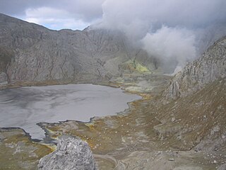
 Crater of Gunung Sibayak. Mount Sinabung in the back.
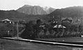 Mount Sibayak in the 1920s
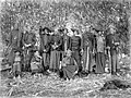 The "Sibajak raja berampat", the so-called four princes with their wives, Karolanden, North Sumatra (1914–1919)

