Thiès is the third largest city in Senegal with a population officially estimated at 320,000 in 2005. It lies 72 km (45 mi) east of Dakar on the N2 road and at the junction of railway lines to Dakar, Bamako and St-Louis. It is the capital of Thiès Region and is a major industrial city.

Sulaco is a municipality in the Honduran department of Yoro.

Rufisque is a city in the Dakar region of western Senegal, at the base of the Cap-Vert Peninsula. It has a population of 179,797. In the past it was an important port city in its own right, but is now a suburb of Dakar.

Louga is a town in northwestern Senegal. Louga is a cattle market centre and has road and rail links with the port city of Saint-Louis to the northwest and Dakar to the southwest. The area surrounding Louga is at the northern limits of Senegal's peanut- (groundnut-) growing area and is inhabited by the Fulani, who are generally pastoral nomads, and the Wolof, who are sedentary farmers. Louga is located in what is called the Ndiambour, which used to be part of the Cayor province.
Inguilpata is a district in the Luya Province, Perú. Inguilpata is located in the high mountains, it offers several attractive places for tourists such as the ruins of the Chachapoya culture as well as a large variety of crafts are available.

Kantora District is one of the four districts of the Upper River Division of the Gambia.
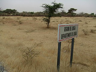
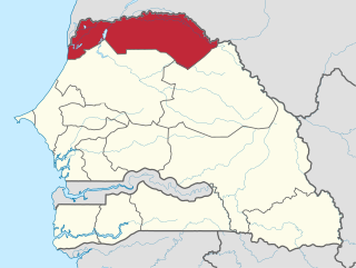
Louga Department is one of the 45 departments of Senegal, and one of the three which comprise the Louga Region.

Kébémer Department is one of the 45 departments of Senegal, and one of the three which make up the Louga Region.

Rufisque Department is one of the 45 departments of Senegal and one of the four which make up the Dakar Region.

The Langue de Barbarie is a thin, sandy peninsula, adjacent to the Atlantic Ocean, located in western Senegal, in the neighbourhood of the city of Saint-Louis. The peninsula separates the ocean from the final section of the Senegal River.
Aldeanueva del Camino is a municipality located in the province of Cáceres, Extremadura, Spain. According to the 2006 census (INE), the municipality has a population of 830 inhabitants.
Meander Glacier is a large meandering tributary to Mariner Glacier in Victoria Land, Antarctica. The glacier emerges in the vicinity of Mount Supernal and Hobbie Ridge and drains generally eastward for 30 nautical miles (56 km) through the Mountaineer Range to join Mariner Glacier just east of Engberg Bluff. The descriptive name was given by the New Zealand Geological Survey Antarctic Expedition, 1962–63.
Guinguinéo Department is one of the 45 departments of Senegal, and one of three which form the Kaolack Region. It was created by decree in 2008.
Křesetice is a village and municipality in Kutná Hora District in the Central Bohemian Region of the Czech Republic.
Gledatsi is a village in Gabrovo Municipality, in Gabrovo Province, in northern central Bulgaria.
Petsovtsi is a village in Gabrovo Municipality, in Gabrovo Province, in northern central Bulgaria.
Peyovtsi is a village in Gabrovo Municipality, in Gabrovo Province, in northern central Bulgaria.
Karala, Estonia is a village in Saaremaa Parish,(previously Lümanda Parish), Saare County in western Estonia.
Hondón de los Frailes is a municipality and village in the province of Alicante and autonomous community of Valencia, Spain. The municipality covers an area of 12.6 square kilometres (4.9 sq mi) and as of 2011 had a population of 1217 people.
Bougoutoub Djinoubor is a village in the rural commune of Oulampane, in the Bignona Department of the Ziguinchor Region of Senegal. In 2002 it had a population of 267 people.