
"Pigtown", also known as "Washington Village" is a neighborhood in the southwest area of Baltimore, bordered by Martin Luther King Jr. Boulevard to the east, Monroe Street to the west, Russell Street to the south, and West Pratt Street to the north. The neighborhood acquired its name during the second half of the 19th century, when the area was the site of butcher shops and meat packing plants to process pigs transported from the Midwest on the B&O Railroad; they were herded across Ostend and Cross Streets to be slaughtered and processed.

Southwest Philadelphia is a section of Philadelphia, Pennsylvania, United States. The section can be described as extending from the western side of the Schuylkill River to the city line, with the SEPTA. The northern border is defined by the Philadelphia City Planning Commission as east from the city line along Baltimore Avenue moving south along 51st Street to Springfield Ave. It follows the train tracks until 49th Street. From 49th and Kingsessing Ave the line moves east along Kingsessing Ave. The line then moves south along 46th St to Paschall Ave where it jogs to join Grays Ferry where the line runs to the Schuylkill River.

Westport is a neighborhood in south Baltimore, Maryland. Westport is a majority African-American neighborhood that has struggled with crime, housing abandonment, and unemployment in the past decade. The neighborhood is bordered by the Middle Branch of the Patapsco River on the east, the city neighborhoods of Cherry Hill, Brooklyn and the southwestern Baltimore County community of Lansdowne to the southwest, Hollins Ferry Road and the Mount Winans and Lakeland neighborhoods to the west, and Interstate 95 to the north, along with the South Baltimore communities of Federal Hill and Otterbein. The Baltimore–Washington Parkway runs through the middle of Westport and intersects with Interstate 95, the main East Coast super-highway, north to south, Maine to Florida.

Maryland Route 140 is a 49-mile (79 km) state highway in the U.S. state of Maryland. The route runs from U.S. Route 1 and US 40 Truck in Baltimore northwest to the Pennsylvania border, where the road continues into that state as Pennsylvania Route 16. MD 140 passes through the northern part of central Maryland, connecting Baltimore, Pikesville, Reisterstown, Westminster, Taneytown, and Emmitsburg.

Otterbein is a small neighborhood of historic rowhouses in Baltimore, Maryland, United States. Otterbein is immediately southwest of, and in close walking distance to, the Inner Harbor. The neighborhood is very compact, entirely located between Hanover Street and Sharp Street, and between Barre Street and Henrietta Street. It is in small parts of zip codes 21201 and 21230. It is named for Old Otterbein Church, located immediately north of the neighborhood.
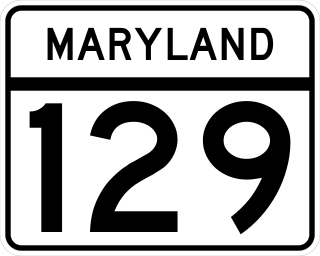
Maryland Route 129 is a state highway in the U.S. state of Maryland, running north-northwesterly from U.S. Route 40 and MD 295 in the city of Baltimore into Baltimore County, ending at Garrison Forest Road east of Reisterstown. The route leaves downtown on the one-way pair of McCulloh Street and Druid Hill Avenue, and then uses the entire length of Park Heights Avenue to the end. MD 129 connects Downtown Baltimore with Druid Hill Park using McCulloh Street and Druid Hill Avenue. As Park Heights Avenue, the state highway is one of two primary radial routes in the northwestern part of the city, providing access to The Maryland Zoo and Pimlico Race Course. In Baltimore County, MD 129 passes through Pikesville, where it has a junction with Interstate 695 (I-695) and serves an affluent rural area north of Pikesville and east of Reisterstown.
Violetville is a neighborhood in Southwest Baltimore, Maryland and Baltimore County. The community is characterized by its "well-kept 1950s and 60s era rowhouses and older farmhouses that date back to the turn of the previous century."

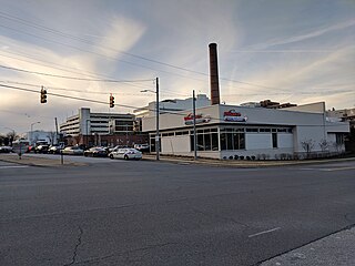
"Mount Winans" is a mixed-use residential, commercial and industrial neighborhood in the southwestern area of the City of Baltimore in Maryland. Its north, south and east boundaries are marked by the various lines of track of the CSX Railroad. In addition, Hollins Ferry Road running to the south towards suburban Baltimore County in the southwest and further connecting with adjacent Anne Arundel County to the southeast, draws its western boundary.
Yale Heights is a neighborhood in the Southwest District of Baltimore, located between Beechfield (west) and Irvington (east). Most of its homes were built in 1955 as a development of two-bedroom, brick townhouses. Its population in 2008 was estimated at 2,916.
Frankford is a neighborhood in northeast Baltimore. Frankford is the most populous of the city's designated neighborhoods, with over 17,000 residents.
Oaklee is a neighborhood in the Southwest District of Baltimore, located at the city's edge between the neighborhoods of Irvington and Violetville. Its boundaries are triangle-shaped, with the Baltimore County line forming its southwestern base. From the triangle's apex to the northeast, U.S. Route 1 branches off from Wilkens Avenue to form the neighborhood's southeastern boundary, while Wilkens draws its northwestern edge from the apex to the base.
Gwynn's Falls is a neighborhood in the Southwestern District of Baltimore, located between Irvington (west) and Gwynns Falls Leakin Park (east). Frederick Avenue marks the neighborhood's boundary to the north; Wilkens Avenue draws its southern edge. Caton Avenue separates it from Irvington to the west.

Saint Agnes is a neighborhood in the Southwest District of Baltimore, located between the neighborhoods of Irvington (north) and Violetville (south). Its boundaries are marked by Wilkens Avenue (south), Caton Avenue (east) and Loudon Park Cemetery (northwest). Saint Agnes Hospital is located on the opposite side (south) of Wilkens Avenue.

Reisterstown Station is a neighborhood in the Northwest District of Baltimore, located between the neighborhoods of Glen (northeast) and Grove Park (southwest). The Baltimore County line is the neighborhood's western border. Its other boundaries are drawn by Reisterstown Road (northeast), West Northern Parkway (southeast), Crest Heights Road (northwest), Patterson Avenue and Wabash Avenue (southwest).
Westgate is a neighborhood in the Southwest District of Baltimore, located between Baltimore County (west) and the city neighborhood of Ten Hills (east). Its boundaries are marked by Baltimore National Pike (north), Frederick Avenue (south), Rock Glen Avenue and Edmondson Avenue (east) and the city line (west).
West Hills is a neighborhood in the Southwest District of Baltimore, located between the neighborhoods of Westgate (south), Franklintown (north) and Hunting Ridge (east). Its boundaries are drawn by the Baltimore County line (west), Baltimore National Pike (south) and North Franklintown Road (north). Its eastern boundary follows Cooks Lane from Baltimore National Pike, then Briarclift Road and finally Wynans Way to the intersection with N. Franklintown Road.

Poppleton is a neighborhood in west Baltimore, Maryland. The neighborhood is bounded on the north by West Mulberry Street, on the south by West Baltimore Street, on the west by North Carey Street, and on the east by the Martin Luther King Jr. Boulevard. Previously, Poppleton was construed in a broader sense extending further south to West Pratt Street or Lombard Street, but today this area is commonly described as the separate neighborhood of Hollins Market.
Mount Holly is a neighborhood in the Southwest District of Baltimore, located between the neighborhoods of Fairmont (south), Walbrook (east) and Garwyn Oaks (north). Its boundaries are drawn by Denison Street (east), Clifton Avenue (southwest), Gwynns Falls Parkway (north), Windsor Mill Road (northwest), and West North Avenue (south). Gwynns Falls Leakin Park is located to the west of Mount Holly.
Levindale is a neighborhood in northwest Baltimore which includes Sinai Hospital, the Levindale Hebrew Geriatric Center and Hospital, and a small number of detached homes and apartment buildings towards its south.


