
Josephine County is one of the 36 counties in the U.S. state of Oregon. As of the 2020 census, the population was 88,090. The county seat is Grants Pass. The county is named after Virginia Josephine Rollins (1834-1912), a settler who was the first white woman to live in the county's boundaries. Josephine County comprises the Grants Pass, OR Metropolitan Statistical Area, which is included in the Medford-Grants Pass, OR Combined Statistical Area.

Oak Grove is an unincorporated community in Clackamas County, Oregon, United States, in the Portland metropolitan area. For statistical purposes, the United States Census Bureau has defined Oak Grove as a census-designated place (CDP). The census definition of the area may not precisely correspond to local understanding of the area with the same name. The population was 16,629 at the 2010 census.
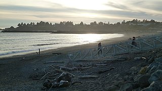
Harbor is an unincorporated community in Curry County, Oregon, United States. It is located across the Chetco River from the city of Brookings. For statistical purposes, the United States Census Bureau has defined Harbor as a census-designated place (CDP). The census definition of the area may not precisely correspond to local understanding of the area with the same name. The population of the CDP was 2,391 at the 2010 census.

Odell is an unincorporated community and census-designated place (CDP) in Hood River County, Oregon, United States. Odell was named for an early pioneer, William Odell, a native of Tennessee by way of California, who settled in the area in 1861. The population was 2,255 as of the 2010 census.

Cave Junction is a city in Josephine County, Oregon, United States. As of the 2020 census, the city population was 1,995. Its motto is the "Gateway to the Oregon Caves", and the city got its name by virtue of its location at the junction of Redwood Highway and Caves Highway. Cave Junction is located in the Illinois Valley, where, starting in the 1850s, the non-native economy depended on gold mining. After World War II, timber became the main source of income for residents. As timber income has since declined, Cave Junction is attempting to compensate with tourism and as a haven for retirees. Tourists visit the Oregon Caves National Monument and Preserve, which includes the Oregon Caves Chateau, as well as the Out'n'About treehouse resort and the Great Cats World Park zoo.

Grants Pass is the county seat of Josephine County, Oregon, United States. The city is located on Interstate 5, northwest of Medford, along the Rogue River. The population is 39,674 according to 2021 census.

Redwood is a census-designated place (CDP) in Josephine County, Oregon, United States. The population was 2,627 at the 2010 census, down from 5,844 at the 2000 census as it has lost territory to the neighboring city of Grants Pass.

Lyle is an unincorporated community and census-designated place (CDP) in Klickitat County, Washington, United States. The population was 499 at the 2010 census.
Leola is a census-designated place (CDP) in Lancaster County, Pennsylvania, United States. It includes the unincorporated communities of Leola, Leacock, and Bareville, and prior to 2010 was known as the Leacock-Leola-Bareville census-designated place. Originally named "Mechanicsburg", its present name is a portmanteau of "Leacock" and the "Glenola" train station that once served the town. As of the 2010 census, the population of the CDP was 7,214.
Selma is an unincorporated community and census-designated place (CDP) in Josephine County, Oregon, United States. As of the 2010 census it had a population of 695. It is located in the ZIP code of 97538.
Takilma is an unincorporated community and census-designated place (CDP) in Josephine County, Oregon, United States, 10 miles (16 km) south of Cave Junction. It is located on the East Fork Illinois River, about a mile southeast of the ghost town of Waldo. As of the 2010 census, it had a population of 378.
Mitchell is an unincorporated community and census-designated place (CDP) in Madison County, Illinois, United States. As of the 2020 census, its population was 1,217. It is part of the Metro East region of greater St. Louis.

Cascadia is an unincorporated community and census-designated place (CDP) that was established in 1892 on the South Santiam River, 14 miles (23 km) east of the current city of Sweet Home, in Linn County, Oregon, United States. As of the 2010 census it had a population of 147.
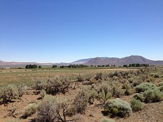
Denio is a census-designated place (CDP) in Humboldt County, Nevada, along the Oregon state line in the United States. The Denio post office was originally north of the state line in Harney County, Oregon, but the residents moved the building into Nevada in the mid-20th century. The population of the CDP, which is entirely in Nevada, was 47 at the 2010 census; additional development considered to be Denio extends into Oregon. The CDP includes a post office, a community center, a library, and the Diamond Inn Bar, the center of the town's social life. Recreational activities in the Denio area include bird watching, photography, off road vehicle use, fishing, recreational black opal mining, rockhounding, hunting, visiting the hot springs, and camping on the Sheldon National Wildlife Refuge.
Merlin is an unincorporated community and census-designated place (CDP) in Josephine County, Oregon, United States. As of the 2010 census it had a population of 1,615. The area is known for sport fishing and whitewater rafting on the Rogue River. Merlin's ZIP code is 97532.
Kerby is an unincorporated community and census-designated place (CDP) in Josephine County, Oregon, United States, north of Cave Junction on U.S. Route 199. As of the 2010 census the population was 595. Despite its population and numerous businesses, it is often listed in tourist guides as a ghost town, because of the number of historic buildings left from its days as a gold-mining town. Kerby came into existence between 1854 and 1857.

Williams is an unincorporated community and census-designated place (CDP) in Josephine County, Oregon, United States. As of the 2010 census it had a population of 1,072.

Lookingglass is an unincorporated community and census-designated place in the Lookingglass Valley of Douglas County, Oregon, United States, about 9 miles (14 km) southwest of Roseburg. As of the 2010 census it had a population of 855. Lookingglass is considered a suburb of Roseburg.
Moro is an unincorporated community and census-designated place (CDP) in Madison County, Illinois, United States. As of the 2020 census it had a population of 387. Moro, like all of Madison County, is part of the Illinois Metro-East region of the Greater St. Louis metropolitan area.
New Hope is an unincorporated community and census-designated place (CDP) in Josephine County, Oregon, United States. As of the 2010 census it had a population of 1,515.


