The Patuxent Range is a major range of the Pensacola Mountains, Antarctica. It comprises the Thomas Hills, Anderson Hills, Mackin Table and various nunataks and ridges bounded by the Foundation Ice Stream, Academy Glacier and the Patuxent Ice Stream.
The Prince Olav Mountains is a mountain group in the Queen Maud Mountains in Antarctica stretching from Shackleton Glacier to Liv Glacier at the head of the Ross Ice Shelf.
The Deep Freeze Range is a rugged mountain range, over 80 nautical miles long and about 10 nautical miles wide, rising between Priestley and Campbell Glaciers in Victoria Land, Antarctica, and extending from the edge of the polar plateau to Terra Nova Bay. It is southwest of the Southern Cross Mountains, south of the Mesa Range and northeast of the Eisenhower Range of the Prince Albert Mountains.
The Hauberg Mountains are a group of mountains of about 35 nautical miles extent, located 12 nautical miles north of Cape Zumberge and 30 nautical miles south of the Sweeney Mountains in eastern Ellsworth Land, Antarctica.
Kohler Range is a mountain range in Marie Byrd Land, Antarctica. The range is about 40 nautical miles long and stands between the base of Martin Peninsula and Smith Glacier. The range consists of two ice-covered plateaus punctuated by several rock peaks and bluffs. The plateaus are oriented East-West and are separated by the Kohler Glacier, a distributary which flows north from Smith Glacier.

The Getz Ice Shelf is an ice shelf over 300 nautical miles long and from 20 to 60 nautical miles wide, bordering the Hobbs Coast and Bakutis Coast of Marie Byrd Land, Antarctica, between the McDonald Heights and Martin Peninsula. Several large islands are partially or wholly embedded in the ice shelf.
The Flood Range is a range of large snow-covered mountains extending in an east–west direction for about 60 nautical miles and forming a right angle with the southern end of the Ames Range in Marie Byrd Land, Antarctica.

Loubet Coast is the portion of the west coast of Graham Land in Antarctic Peninsula, extending 158 km between Cape Bellue to the northeast and Bourgeois Fjord to the southwest. South of Loubet Coast is Fallières Coast, north is Graham Coast.
Mikkelsen Bay is a bay, 15 nautical miles wide at its mouth and indenting 10 nautical miles, entered between Bertrand Ice Piedmont and Cape Berteaux along the west coast of Graham Land, Antarctica.
Northeast Glacier is a steep, heavily crevassed glacier, 13 nautical miles long and 5 nautical miles wide at its mouth, which flows from McLeod Hill westward and then south-westwards into Marguerite Bay between the Debenham Islands and Roman Four Promontory, on the west coast of Graham Land, Antarctica.

The Prince Charles Mountains are a major group of mountains in Mac. Robertson Land in Antarctica, including the Athos Range, the Porthos Range, and the Aramis Range. The highest peak is Mount Menzies, with a height of 3,228 m (10,591 ft). Other prominent peaks are Mount Izabelle and Mount Stinear. These mountains, together with other scattered peaks, form an arc about 420 km (260 mi) long, extending from the vicinity of Mount Starlight in the north to Goodspeed Nunataks in the south.
Foundation Ice Stream is a major ice stream in the Pensacola Mountains of Antarctica. The ice stream drains northward for 150 nautical miles along the west side of the Patuxent Range and the Neptune Range to enter the Ronne Ice Shelf westward of Dufek Massif.
Mount Wilcox is a mountain with a sharp, rocky, triangular peak surmounting the southeast corner of Square Bay, 13 kilometres (8 mi) east of Camp Point on the west coast of Graham Land, Antarctica. The mountain was apparently first seen and roughly charted in 1909 by the French Antarctic Expedition under Charcot. It was surveyed in 1936 by the British Graham Land Expedition (BGLE) under John Rymill and was photographed from the air in 1940 by the United States Antarctic Service (USAS). The name, proposed by Colonel Lawrence Martin, is for Phineas Wilcox, mate on the Hero, in which Captain Nathaniel Palmer explored the Antarctic mainland south of Deception Island in 1820.
On the continent of Antarctica, the Aramis Range is the third range south in the Prince Charles Mountains, situated 11 miles southeast of the Porthos Range and extending for about 30 miles in a southwest–northeast direction. It was first visited in January 1957 by Australian National Antarctic Research Expeditions (ANARE) southern party led by W.G. Bewsher, who named it for a character in Alexandre Dumas' novel The Three Musketeers, the most popular book read on the southern journey.
The Gothic Mountains is a group of mountains, 20 nautical miles long, in the Queen Maud Mountains of Antarctica, located west of Watson Escarpment and bounded by Scott Glacier, Albanus Glacier, and Griffith Glacier.

Swithinbank Glacier is a glacier on the west side of Hemimont Plateau flowing north to the southeast corner of Square Bay, in Graham Land. Mapped by Falkland Islands Dependencies Survey (FIDS) from surveys and air photos, 1946–59. Named by United Kingdom Antarctic Place-Names Committee (UK-APC) for Charles Swithinbank, British glaciologist, a participant in several British, New Zealand and American expeditions to Antarctica, 1949–62.
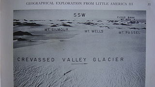
The Denfeld Mountains are a group of scattered mountains between Crevasse Valley Glacier and Arthur Glacier in the Ford Ranges of Marie Byrd Land, Antarctica.
The Playfair Mountains are a group of mountains between Swann Glacier and Squires Glacier in southeast Palmer Land, Antarctica.
Relay Hills is a group of low, ice-covered hills, mainly conical in shape, between Mount Edgell and Kinnear Mountains in western Antarctic Peninsula. First roughly surveyed from the ground by British Graham Land Expedition (BGLE), 1936–37. Photographed from the air by Ronne Antarctic Research Expedition (RARE), November 1947. Resurveyed by Falkland Islands Dependencies Survey (FIDS), November 1958. The name, applied by the United Kingdom Antarctic Place-Names Committee (UK-APC), arose because both the BGLE and the FIDS sledging parties had to relay their loads through this area to the head of Prospect Glacier.