Related Research Articles

The Red River Gorge is a canyon system on the Red River in east-central Kentucky. Geologically it is part of the Pottsville Escarpment.

Cumberland Falls, sometimes called the Little Niagara, the Niagara of the South, or the Great Falls, is a waterfall on the Cumberland River in southeastern Kentucky. Spanning the river at the border of McCreary and Whitley counties, the waterfall is the central feature of Cumberland Falls State Resort Park and is part of the Office of Kentucky Nature Preserves designated Wild River System.

Powell County is a county located in the U.S. Commonwealth of Kentucky. As of the 2020 census, the population was 13,129. Its county seat is Stanton. The county was formed January 7, 1852, by Kentucky Governor Lazarus W. Powell from parts of Clark, Estill, and Montgomery counties. It is no longer a dry county as of 2018.

Pineville is a home rule-class city in Bell County, Kentucky, United States. It is the seat of its county. The population was 1,732 as of the 2010 census. It is located on a small strip of land between the Cumberland River and Pine Mountain.

The Pennyroyal Plateau or Pennyroyal Region, often spelled Pennyrile, is a large physiographic region of Kentucky that features rolling hills, caves, and karst topography in general. It is named for a wild mint that grows in the area. It is also called the "Mississippian Plateau," for the Mississippian geologic age in which it was formed.
Muldraugh Hill is an escarpment in Bullitt, Hardin, Jefferson, and Nelson counties of central Kentucky separating the Bluegrass on the north and north-east from the Pennyrile on the south and south-west. This escarpment fades into the Pottsville Escarpment on the east, and terminates at the Ohio River in the west, although in truth it continues in Indiana as Floyds Knobs.

The Cumberland Plateau is the southern part of the Appalachian Plateau in the Appalachian Mountains of the United States. It includes much of eastern Kentucky and Tennessee, and portions of northern Alabama and northwest Georgia. The terms "Allegheny Plateau" and the "Cumberland Plateau" both refer to the dissected plateau lands lying west of the main Appalachian Mountains. The terms stem from historical usage rather than geological difference, so there is no strict dividing line between the two. Two major rivers share the names of the plateaus, with the Allegheny River rising in the Allegheny Plateau and the Cumberland River rising in the Cumberland Plateau in Harlan County, Kentucky.
The Nashville Basin, also known as the Central Basin, is a term often used to describe the area surrounding Murfreesboro, Tennessee, in which Nashville is located. The Central Basin was caused by an uplifting which produced a dome known as the Nashville Dome. The Nashville Dome is evidenced by the underlying rock strata that all dip downwards away from Nashville. The uplifting of the Nashville Dome fractured overlying strata, making it more easily eroded and thus the "dome" resulted in a "basin". Uplifted strata in the center of a geological dome have higher potential erosive energy than the surrounding strata, because they are physically higher. Erosion thus acts on the uplifted area at a greater rate than on the surrounding flat-lying area, creating a low area, i.e. a basin. This area is more correctly referred to as the "Central Dome" of Tennessee.
The Highland Rim is a geographic term for the area in Tennessee surrounding the Central Basin. Nashville is largely surrounded by higher terrain in all directions.

The Cumberland Mountains are a mountain range in the southeastern section of the Appalachian Mountains. They are located in western Virginia, southwestern West Virginia, the eastern edges of Kentucky, and eastern middle Tennessee, including the Crab Orchard Mountains. Their highest peak, with an elevation of 4,223 feet (1,287 m) above mean sea level, is High Knob, which is located near Norton, Virginia.

The Collins River is a 67-mile-long (108 km) stream in the east-central portion of Middle Tennessee in the United States. It is a tributary of the Caney Fork, and is part of the Cumberland, Ohio and Mississippi watersheds. The river drains the scenic Savage Gulf area, located just below the river's source, and empties into Great Falls Lake at Rock Island State Park.

The Sequatchie River is a 116-mile-long (187 km) waterway that drains the Sequatchie Valley, a large valley in the Cumberland Plateau in Tennessee. It empties into the Tennessee River downstream from Chattanooga near the Tennessee-Alabama state line.

The Big South Fork of the Cumberland River is a 76-mile-long (122 km) river in the U.S. states of Tennessee and Kentucky. It is a major drainage feature of the Cumberland Plateau, a major tributary of the Cumberland River system, and the major feature of the Big South Fork National River and Recreation Area.

The Cumberland Gap National Historical Park is a United States National Historical Park located at the border between Kentucky, Tennessee, and Virginia, centered on the Cumberland Gap, a natural break in the Appalachian Mountains.

The Sheltowee Trace Trail is a 343-mile (552.00 km) National Recreation Trail that was created in 1979 and stretches from the Burnt Mill Bridge Trail Head in the Big South Fork National River and Recreation Area in Tennessee to northern Rowan County, Kentucky. The trail is named after Daniel Boone, who was given the name Sheltowee when he was adopted as the son of the great warrior Chief Blackfish of the Shawnee tribe.

The Knobs Region or The Knobs is located in the US state of Kentucky. It is a narrow, arc-shaped region consisting of hundreds of isolated hills. The region wraps around the southern and eastern parts of the Bluegrass region in the north central to northeastern part of the state. The western end of the Knobs region begins near Louisville, Kentucky and continues southeastward through Bullitt, Hardin, Nelson, LaRue, Marion, Taylor, Boyle, Casey and Lincoln counties before turning northeast and running along the Pottsville Escarpment and the Appalachian Plateau. The Knob arc has a length of 230 miles (370 km).

The Big South Fork National River and Recreation Area, commonly known as Big South Fork, preserves the Big South Fork of the Cumberland River and its tributaries in northeastern Tennessee and southeastern Kentucky.
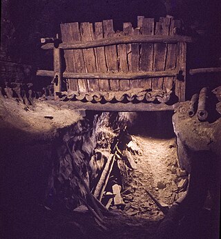
(Big) Bone Cave is a cave located in Van Buren County, Tennessee, in the community of Bone Cave that is named after it. It is notable both for its history and current recreational use. It is listed on the National Register of Historic Places and a designated National Natural Landmark. It is a 400-acre (161.9 ha) State Natural Area managed by Rock Island State Park. It is named for the discovery of the bones of a giant ground sloth in 1811. The cave was operated as a saltpeter mine, notably during the War of 1812 and the American Civil War. A variety of natural remains and human artifacts have been well preserved in the dry atmosphere of the cave. The cave is the 10th longest mapped cave in Tennessee.

The Eastern Kentucky Coalfield is part of the Central Appalachian bituminous coalfield, including all or parts of 30 Kentucky counties and adjoining areas in Ohio, West Virginia, Virginia and Tennessee. It covers an area from the Allegheny Mountains in the east across the Cumberland Plateau to the Pottsville Escarpment in the west. The region is known for its coal mining; most family farms in the region have disappeared since the introduction of surface mining in the 1940s and 1950s.
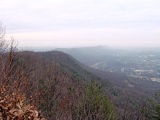
Walden Ridge is a mountain ridge and escarpment located in Tennessee, in the United States. It marks the eastern edge of the Cumberland Plateau and is generally considered part of it. Walden Ridge is about 74 miles (119 km) long, running generally north-south. Its highest point is at Hinch Mountain, which reaches 3,048 feet (929 m) above sea level. Sometimes Walden Ridge is called the Cumberland Escarpment.
References
Coordinates: 37°50′2″N83°36′28″W / 37.83389°N 83.60778°W
| | This Kentucky state location article is a stub. You can help Wikipedia by expanding it. |