Related Research Articles

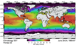
Satellite temperature measurements are inferences of the temperature of the atmosphere at various altitudes as well as sea and land surface temperatures obtained from radiometric measurements by satellites. These measurements can be used to locate weather fronts, monitor the El Niño-Southern Oscillation, determine the strength of tropical cyclones, study urban heat islands and monitor the global climate. Wildfires, volcanos, and industrial hot spots can also be found via thermal imaging from weather satellites.

A microwave radiometer (MWR) is a radiometer that measures energy emitted at millimetre-to-centimetre wavelengths known as microwaves. Microwave radiometers are very sensitive receivers designed to measure thermal electromagnetic radiation emitted by atmospheric gases. They are usually equipped with multiple receiving channels in order to derive the characteristic emission spectrum of the atmosphere or extraterrestrial objects. Microwave radiometers are utilized in a variety of environmental and engineering applications, including weather forecasting, climate monitoring, radio astronomy and radio propagation studies.

Clouds and the Earth's Radiant Energy System (CERES) is on-going NASA climatological experiment from Earth orbit. The CERES are scientific satellite instruments, part of the NASA's Earth Observing System (EOS), designed to measure both solar-reflected and Earth-emitted radiation from the top of the atmosphere (TOA) to the Earth's surface. Cloud properties are determined using simultaneous measurements by other EOS instruments such as the Moderate Resolution Imaging Spectroradiometer (MODIS). Results from the CERES and other NASA missions, such as the Earth Radiation Budget Experiment (ERBE), could lead to a better understanding of the role of clouds and the energy cycle in global climate change.
The Advanced Very-High-Resolution Radiometer (AVHRR) instrument is a space-borne sensor that measure the reflectance of the Earth in five spectral bands that are relatively wide by today's standards. AVHRR instruments are or have been carried by the National Oceanic and Atmospheric Administration (NOAA) family of polar orbiting platforms (POES) and European MetOp satellites. The instrument scans several channels; two are centered on the red (0.6 micrometres) and near-infrared (0.9 micrometres) regions, a third one is located around 3.5 micrometres, and another two the thermal radiation emitted by the planet, around 11 and 12 micrometres.
Atmospheric sounding or atmospheric profiling is a measurement of vertical distribution of physical properties of the atmospheric column such as pressure, temperature, wind speed and wind direction, liquid water content, ozone concentration, pollution, and other properties. Such measurements are performed in a variety of ways including remote sensing and in situ observations.
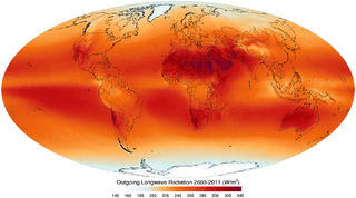
Outgoing Long-wave Radiation (OLR) is electromagnetic radiation of wavelengths from 3–100 μm emitted from Earth and its atmosphere out to space in the form of thermal radiation. It is also referred to as up-welling long-wave radiation and terrestrial long-wave flux, among others. The flux of energy transported by outgoing long-wave radiation is measured in W/m2. In the Earth's climate system, long-wave radiation involves processes of absorption, scattering, and emissions from atmospheric gases, aerosols, clouds and the surface.

Over the last two centuries many environmental chemical observations have been made from a variety of ground-based, airborne, and orbital platforms and deposited in databases. Many of these databases are publicly available. All of the instruments mentioned in this article give online public access to their data. These observations are critical in developing our understanding of the Earth's atmosphere and issues such as climate change, ozone depletion and air quality. Some of the external links provide repositories of many of these datasets in one place. For example, the Cambridge Atmospheric Chemical Database, is a large database in a uniform ASCII format. Each observation is augmented with the meteorological conditions such as the temperature, potential temperature, geopotential height, and equivalent PV latitude.
Thermophysics in general is the geological application of thermal physics which is related to the classical physics study of thermal science.
The MEMO model is a Eulerian non-hydrostatic prognostic mesoscale model for wind-flow simulation. It was developed by the Aristotle University of Thessaloniki in collaboration with the Universität Karlsruhe. The MEMO Model together with the photochemical dispersion model MARS are the two core models of the European zooming model (EZM). This model belongs to the family of models designed for describing atmospheric transport phenomena in the local-to-regional scale, frequently referred to as mesoscale air pollution models.
An Atmospheric radiative transfer model, code, or simulator calculates radiative transfer of electromagnetic radiation through a planetary atmosphere, such as the Earth's.
4A/OP or, Automatized Atmospheric Absorption Atlas, is an operational fast and accurate radiative transfer model for the infrared.

Sentinel-3 is an Earth observation satellite constellation developed by the European Space Agency as part of the Copernicus Programme. It currently consists of 2 satellites: Sentinel-3A and Sentinel-3B. Two more satellites, Sentinel-3C and Sentinel-3D, are on order.
The Advanced Along Track Scanning Radiometer (AATSR) is one of the Announcement of Opportunity (AO) instruments on board the European Space Agency (ESA)'s Envisat satellite.
The Community Radiative Transfer Model (CRTM) is a fast radiative transfer model for calculations of radiances for satellite infrared or microwave radiometers.
Frank Wentz is the CEO and director of Remote Sensing Systems, a company he founded in 1974. Remote Sensing Systems specializes in satellite microwave remote sensing research. Together with Carl Mears, he is best known for developing a satellite temperature record from MSU and AMSU. Intercomparison of this record with the earlier UAH satellite temperature record, developed by John Christy and Roy Spencer, revealed deficiencies in the earlier work; specifically, the warming trend in the RSS version is larger than the University of Alabama in Huntsville (UAH) one. From 1978 to 1982 Frank was a member of NASA's SeaSat Experiment Team involved in the development of physically based retrieval methods for microwave scatterometers and radiometers. He has also investigated the effect of climate change on satellite-derived evaporation, precipitation and surface wind values. His findings are different from most climate change model predictions.
Collocation is a procedure used in remote sensing to match measurements from two or more different instruments. This is done for two main reasons: for validation purposes when comparing measurements of the same variable, and to relate measurements of two different variables either for performing retrievals or for prediction. In the second case the data is later fed into some type of statistical inverse method such as an artificial neural network, statistical classification algorithm, kernel estimator or a linear least squares. In principle, most collocation problems can be solved by a nearest neighbor search, but in practice there are many other considerations involved and the best method is highly specific to the particular matching of instruments. Here we deal with some of the most important considerations along with specific examples.
With increased interest in sea ice and its effects on the global climate, efficient methods are required to monitor both its extent and exchange processes. Satellite-mounted, microwave radiometers, such SSMI, AMSR and AMSU, are an ideal tool for the task because they can see through cloud cover, and they have frequent, global coverage. A passive microwave instrument detects objects through emitted radiation since different substance have different emission spectra. To detect sea ice more efficiently, there is a need to model these emission processes. The interaction of sea ice with electromagnetic radiation in the microwave range is still not well understood. In general is collected information limited because of the large-scale variability due to the emissivity of sea ice.
Satellite surface salinity refers to measurements of surface salinity made by remote sensing satellites. The radiative properties of the ocean surface are exploited in order to estimate the salinity of the water's surface layer.

ARTS is a widely used atmospheric radiative transfer simulator for infrared, microwave, and sub-millimeter wavelengths. While the model is developed by a community, core development is done by the University of Hamburg and Chalmers University, with previous participation from Luleå University of Technology and University of Bremen.
The skin temperature of an atmosphere is the temperature of a hypothetical thin layer high in the atmosphere that is transparent to incident solar radiation and partially absorbing of infrared radiation from the planet. It provides an approximation for the temperature of the tropopause on terrestrial planets with greenhouse gases present in their atmospheres.
References
- Eyre J. R. 1991 A fast radiative transfer model for satellite sounding systems. ECMWF Research Dept. Tech. Memo. 176 (available from the librarian at ECMWF).
- Matricardi, M., F. Chevallier and S. Tjemkes 2001 An improved general fast radiative transfer model for the assimilation of radiance observations. ECMWF Research Dept. Tech. Memo. 345. http://www.ecmwf.int/publications
- Saunders R.W., M. Matricardi and P. Brunel 1999 An Improved Fast Radiative Transfer Model for Assimilation of Satellite Radiance Observations. Quart. J.Royal Meteorol. Soc., 125, 1407-1425.