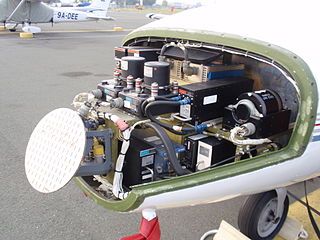
Avionics are the electronic systems used on aircraft, artificial satellites, and spacecraft. Avionic systems include communications, navigation, the display and management of multiple systems, and the hundreds of systems that are fitted to aircraft to perform individual functions. These can be as simple as a searchlight for a police helicopter or as complicated as the tactical system for an airborne early warning platform. The term avionics is a portmanteau of the words aviation and electronics.

The OC-135B Open Skies United States Air Force observation aircraft supports the Treaty on Open Skies. The aircraft, a modified WC-135B, flies unarmed observation flights over participating parties of the treaty. Three OC-135B aircraft were modified by the Aeronautical Systems Center's 4950th Test Wing at Wright-Patterson Air Force Base in Ohio. The first operationally-capable OC-135B was assigned to the 24th Reconnaissance Squadron at Offutt AFB in October 1993. It is now fitted with a basic set of navigational and sensor equipment, and was placed in inviolate storage at the Aerospace Maintenance and Regeneration Center at Davis-Monthan Air Force Base near Tucson, Arizona in 1997. Two fully operational OC-135B aircraft were delivered in 1996 with the full complement of treaty-allowed sensors, which includes an infrared line scanner, synthetic aperture radar and video scanning sensors.
NewTek, Inc. is a San Antonio, Texas–based hardware and software company that produces live and post-production video tools and visual imaging software for personal computers. The company was founded in 1985 in Topeka, Kansas, United States, by Tim Jenison and Paul Montgomery.

Aerial photography is the taking of photographs from an aircraft or other flying object. Platforms for aerial photography include fixed-wing aircraft, helicopters, unmanned aerial vehicles, balloons, blimps and dirigibles, rockets, pigeons, kites, parachutes, stand-alone telescoping and vehicle-mounted poles. Mounted cameras may be triggered remotely or automatically; hand-held photographs may be taken by a photographer.

James Hansen Newman, Ph.D. is an American physicist and a former NASA astronaut who flew on four Space Shuttle missions.

A ground control station (GCS) is a land- or sea-based control centre that provides the facilities for human control of Unmanned Aerial Vehicles. It may also refer to a system for controlling rockets within or above the atmosphere, but this is discussed elsewhere.

Mobile computing is human–computer interaction by which a computer is expected to be transported during normal usage, which allows for transmission of data, voice and video. Mobile computing involves mobile communication, mobile hardware, and mobile software. Communication issues include ad hoc networks and infrastructure networks as well as communication properties, protocols, data formats and concrete technologies. Hardware includes mobile devices or device components. Mobile software deals with the characteristics and requirements of mobile applications.
Aeronautical Radio, Incorporated (ARINC), established in 1929, is a major provider of transport communications and systems engineering solutions for eight industries: aviation, airports, defense, government, healthcare, networks, security, and transportation. ARINC has installed computer data networks in police cars and railroad cars and also maintains the standards for line-replaceable units.

A character generator, often abbreviated as CG, is a device or software that produces static or animated text for keying into a video stream. Modern character generators are computer-based, and can generate graphics as well as text.
Video assist is a system used in filmmaking which allows filmmakers to view a video version of a take immediately after it is filmed.
An electronic flight bag (EFB) is an electronic information management device that helps flight crews perform flight management tasks more easily and efficiently with less paper. It is a general purpose computing platform intended to reduce, or replace, paper-based reference material often found in the pilot's carry-on flight bag, including the aircraft operating manual, flight-crew operating manual, and navigational charts. In addition, the EFB can host purpose-built software applications to automate other functions normally conducted by hand, such as performance take-off calculations.

Airborne Real-time Cueing Hyperspectral Enhanced Reconnaissance, also known by the acronym ARCHER, is an aerial imaging system that produces ground images far more detailed than plain sight or ordinary aerial photography can.
It is the most sophisticated unclassified hyperspectral imaging system available, according to U.S. Government officials.
ARCHER can automatically scan detailed imaging for a given signature of the object being sought, for abnormalities in the surrounding area, or for changes from previous recorded spectral signatures.
The Cornell University Satellite (CUSat) is a nanosatellite developed by Cornell University that launched on 29 September 2013. It used a new algorithm called Carrier-phase Differential GPS (CDGPS) to calibrate global positioning systems to an accuracy of 3 millimeters. This technology can allow multiple spacecraft to travel in close proximity.
Network Centric Product Support (NCPS) is an early application of an Internet of Things (IoT) computer architecture developed to leverage new information technologies and global networks to assist in managing maintenance, support and supply chain of complex products made up of one or more complex systems, such as in a mobile aircraft fleet or fixed location assets such as in building systems. This is accomplished by establishing digital threads connecting the physical deployed subsystem with its design Digital Twins virtual model by embedding intelligence through networked micro-web servers that also function as a computer workstation within each subsystem component or other controller and enabling 2-way communications using existing Internet technologies and communications networks - thus allowing for the extension of a product lifecycle management (PLM) system into a mobile, deployed product at the subsystem level in real time. NCPS can be considered to be the support flip side of Network-centric warfare, as this approach goes beyond traditional logistics and aftermarket support functions by taking a complex adaptive system management approach and integrating field maintenance and logistics in a unified factory and field environment. Its evolution began out of insights gained by CDR Dave Loda (USNR) from Network Centric Warfare-based fleet battle experimentation at the US Naval Warfare Development Command (NWDC) in the late 1990s, who later lead commercial research efforts of NCPS in aviation at United Technologies Corporation. Interaction with the MIT Auto-ID Labs, EPCglobal, the Air Transport Association of America ATA Spec 100/iSpec 2200 and other consortium pioneering the emerging machine to machine Internet of Things (IoT) architecture contributed to the evolution of NCPS.
An Airborne Network (AN) is the infrastructure owned by the United States Air Force that provides communication transport services through at least one node that is on a platform capable of flight.

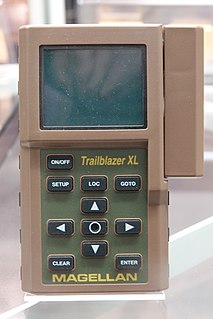
A GPS navigation device, GPS receiver, or simply GPS is a device that is capable of receiving information from GPS satellites and then to calculate the device's geographical position. Using suitable software, the device may display the position on a map, and it may offer directions. The Global Positioning System (GPS) is a global navigation satellite system (GNSS) made up of a network of a minimum of 24, but currently 30, satellites placed into orbit by the U.S. Department of Defense.
Uncompressed video is digital video that either has never been compressed or was generated by decompressing previously compressed digital video. It is commonly used by video cameras, video monitors, video recording devices, and in video processors that perform functions such as image resizing, image rotation, deinterlacing, and text and graphics overlay. It is conveyed over various types of baseband digital video interfaces, such as HDMI, DVI, DisplayPort and SDI. Standards also exist for carriage of uncompressed video over computer networks.

The Deployable Joint Command and Control system, commonly known as DJC2, is an integrated command and control headquarters system which enables a commander to set up a self-contained, self-powered, computer network-enabled temporary headquarters facility anywhere in the world within 6 – 24 hours of arrival at a location.
Elevated photography is the process of taking aerial photos using a telescoping pole or mast, or other aerial or elevated support systems, to emulate aerial photographs, or video, taken from a commercially licensed aircraft.
Unmanned aircraft system simulation focuses on training pilots to control an unmanned aircraft or its payload from a control station. Flight simulation involves a device that artificially re-creates aircraft flight and the environment in which it flies for pilot training, design, or other purposes. It includes replicating the equations that govern how aircraft fly, how they react to applications of flight controls, the effects of other aircraft systems, and how the aircraft reacts to external factors such as air density, turbulence, wind shear, cloud, precipitation, etc.


