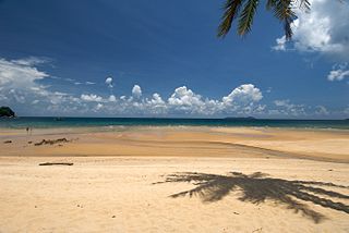
Tioman Island is 32 kilometres off the east coast of Rompin District, Pahang, Malaysia. It is 39 kilometres long and 12 kilometres wide and has seven villages, the largest and most populous being Kampung Tekek on the central western coast. The densely forested island is sparsely inhabited, and is surrounded by numerous coral reefs, making it a popular scuba diving, snorkelling, and surfing spot. There are many resorts and chalets for tourists around the island, which has duty-free status.

Jurong Island is an island located to the southwest of the main island of Singapore. It was formed from the amalgamation of seven offshore islands, the islands of Pulau Ayer Chawan, Pulau Ayer Merbau, Pulau Merlimau, Pulau Pesek, Pulau Pesek Kechil, Pulau Sakra, Pulau Seraya, Pulau Meskol, Pulau Mesemut Laut, Pulau Mesemut Darat and Anak Pulau. This was done through Singapore's land reclamation efforts. Land reclamation on Jurong Island was completed on 25 September 2009, 20 years earlier than scheduled. Pulau Buaya was joined to Jurong Island via reclamation in 2010. Jurong Island forms a land area of about 32 km2 (12 sq mi) from an initial area of less than 10 km2 (4 sq mi), and is the largest of Singapore's outlying islands.

Pulau Ubin, also simply known as Ubin, is an island situated in the north east of Singapore, to the west of Pulau Tekong. The granite quarry used to be supported by a few thousand settlers on Pulau Ubin in the 1960s, but only about 40 villagers remained as of 2012. It is one of the last rural areas to be found in Singapore, with an abundance of natural flora and fauna. The island forms part of the Ubin–Khatib Important Bird Area (IBA), identified as such by BirdLife International because it supports significant numbers of visiting and resident birds, some of which are threatened. Today, the island is managed by the National Parks Board, compared to 12 agencies managing different areas of the island previously.

Pedra Branca is an outlying island and the easternmost point of Singapore. The name of the island refers to whitish guano deposited on the rock. The island consists of a small outcrop of granite rocks with an area of about 8,560 square metres (92,100 sq ft) at low tide. During the low water spring tide it measures, at its longest, 137 metres (449 ft) and has an average width of 60 metres (200 ft). Pedra Branca is situated at 1°19′48″N104°24′27″E, where the Singapore Strait meets the South China Sea.
Keppel Harbour, also called the Keppel Channel and formerly New Harbour, is a stretch of water in Singapore between the mainland and the southern islands of Pulau Brani and Sentosa. Its naturally sheltered and deep waters was to meet the requirements of British colonists attempting to establish a Far East maritime colony in that part of the world, thereby setting the stage for the eventual formation of Singapore as a successful independent state.

The Orang Laut are several seafaring ethnic groups and tribes living around Singapore, peninsular Malaysia and the Indonesian Riau Islands. The Orang Laut are commonly identified as the Orang Seletar from the Straits of Johor, but the term may also refer to any Malayic-speaking people living on coastal islands, including those of Mergui Archipelago islands of Myanmar and Thailand, commonly known as Moken.
Pulau Hantu is located to the south of the main island of Singapore, off the Straits of Singapore. Pulau Hantu is actually made up of two islets: Pulau Hantu Besar and Pulau Hantu Kechil, with a total area of 12.6 hectares. At low tide, it is possible to wade across the shallow lagoon between the two islands, but not at high tide.

Redang Island is an island in Kuala Nerus District, Terengganu, Malaysia. It is one of the largest islands off the east coast of Peninsular Malaysia and one of the most beautiful islands in the world. It is famous for its crystal clear waters and white sandy beaches. It is one of nine islands, which form a marine sanctuary park offering snorkeling and diving opportunities for tourists.
Pulau Semakau is located to the south of the main island of Singapore, off the Straits of Singapore. The Semakau Landfill is located on the eastern side of the island, and was created by the amalgamation of Pulau Sakeng, and "anchored" to Pulau Semakau. The Semakau Landfill is Singapore's first offshore landfill and now the only remaining landfill in Singapore.

Semporna is the capital of the Semporna District in the Tawau Division of Sabah, Malaysia. Its population was estimated to be around 35,301 in 2010.

The Southern Islands is a planning area consisting of a collection of islets located within the Central Region of Singapore, once home to the native Malay islanders and sea nomads before they were relocated to the mainland for urban redevelopment and future use. The islands that form the planning area are Kusu Island, Lazarus Island, Pulau Seringat, Pulau Tekukor, Saint John's Island, Sentosa and the two Sisters' Islands. The islands encompass a total land area of about 5.58 square kilometres (2.15 sq mi). The Sentosa Development Corporation oversaw the development and maintenance of these offshore islands south of Singapore from 1976 to March 2017, when it handed it back to the Singapore Land Authority.

Operation Rimau was an attack on Japanese shipping in Singapore Harbour, carried out by an Allied commando unit Z Special Unit, during World War II using Australian built Hoehn military MKIII folboats. It was a follow-up to the successful Operation Jaywick which had taken place in September 1943, and was again led by Lieutenant Colonel Ivan Lyon of the Gordon Highlanders, an infantry regiment of the British Army.

The Police Coast Guard (PCG) is a division of the Singapore Police Force that combines the functions of marine police and coast guard in Singapore. Its duties include the law enforcement and search and rescue operations in collaboration with the Maritime and Port Authority of Singapore and the Immigration and Checkpoints Authority. It is headquartered at Brani Regional Base on Pulau Brani.

Serangoon Harbour is a harbour in Singapore located between the mainland island of Singapore and Pulau Ubin.
Long Ya Men or Dragon's Teeth Gate, is the name Chinese explorer Wang Dayuan recorded for Batu Belayar, a craggy granite outcrop that formerly stood at the gateway to Keppel Harbour in Singapore. In his description, “The strait runs between the two hills of the Danmaxi (Temasek) natives which looked like dragon’s teeth.” From there, the name Long Ya Men or Dragon Teeth’s Gate was born.

The Pedra Branca dispute was a territorial dispute between Singapore and Malaysia over several islets at the eastern entrance to the Singapore Strait, namely Pedra Branca, Middle Rocks and South Ledge. The dispute began in 1979 and was largely resolved by the International Court of Justice (ICJ) in 2008, which opined that Pedra Branca belonged to Singapore and Middle Rocks belonged to Malaysia. Sovereignty over South Ledge belongs to the state in the territorial waters of which it is located.

The Marine Police Force, Royal Malaysia Police is the Marine Police division of the Royal Malaysia Police tasked with maintaining law and order and execute national security operations in the Malaysian Territorial Waters (MTW) and no boundaries till the high seas. The Marine Police Force serves under the control of the Malaysian Internal Security & Public Order (ISPO) Department with the role of safeguarding the security of Malaysian waters from any threats.

The Aur Island is an island in Mersing District, Johor, Malaysia. It lies about 76 kilometres (47 mi) east of Mersing Town and is part of the Johor Marine Park. Its corals, lagoons and offshore pools make it a tourist attraction. It has for many years also been a frequent stopover point for fishermen.
Pulo Jehat is an island located in the Straits of Johor. The name means Wicked Island.
Sisters’ Islands Marine Park is a 400,000 square metre(40ha) marine park located in Southern Islands planning area, Singapore, which was designated a marine protected area (MPA) by the Government of Maritime and Port Authority of Singapore in 2014. The park encompasses the land and waters surrounding Sisters' Islands, and also covers the western coasts of both St John's Island and Pulau Tekukor.

