
The London Borough of Enfield is a London borough in North London. It borders the London boroughs of Barnet to the west, Haringey to the south, and Waltham Forest to the southeast. To the north are the districts of Hertsmere, Welwyn Hatfield and Broxbourne, and to the east is Epping Forest District in Essex. The local authority is Enfield London Borough Council. Enfield's population is estimated to be 333,794; the main towns in the borough are Edmonton, Enfield, Southgate and Palmers Green. Enfield is the northernmost London borough.

Southbury is a town in western New Haven County, Connecticut, United States. Southbury is north of Oxford and Newtown, and east of Brookfield. Its population was 19,879 at the 2020 census. The town is part of the Naugatuck Valley Planning Region.

Enfield is a large town in north London, England, 10.1 miles (16.3 km) north of Charing Cross. It had a population of 156,858 in 2018. It includes the areas of Botany Bay, Brimsdown, Bulls Cross, Bullsmoor, Bush Hill Park, Clay Hill, Crews Hill, Enfield Highway, Enfield Lock, Enfield Town, Enfield Wash, Forty Hill, Freezywater, Gordon Hill, Grange Park, Hadley Wood, Ponders End, and World's End.

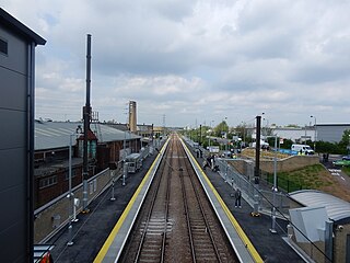
Southbury is a London Overground station on the Southbury Loop section of the Lea Valley lines, located on the easterly side of Enfield in north London. It is 10 miles 32 chains (16.7 km) down the line from London Liverpool Street and is situated between Edmonton Green and Turkey Street.

Turkey Street is a London Overground station on the Southbury Loop section of the Lea Valley lines, located in the Bullsmoor area to the north of Enfield in north London. It is 12 miles 16 chains (19.6 km) down the line from London Liverpool Street and is situated between Southbury and Theobalds Grove.

The Lea Valley lines are two commuter lines and two branches in north-east London, so named because they run along the Lower Lea Valley of the River Lea. They were part of the Great Eastern Railway, now part of the Anglia Route of Network Rail.

A passing loop or passing siding is a place on a single line railway or tramway, often located at or near a station, where trains or trams travelling in opposite directions can pass each other. Trains/trams going in the same direction can also overtake, provided that the signalling arrangement allows it. A passing loop is double-ended and connected to the main track at both ends, though a dead end siding known as a refuge siding, which is much less convenient, can be used. A similar arrangement is used on the gauntlet track of cable railways and funiculars, and in passing places on single-track roads.

Cheshunt is a National Rail and London Overground station in Cheshunt, Hertfordshire, England. On the National Rail network it is on the West Anglia Main Line, 14 miles 1 chain (22.6 km) from London Liverpool Street and situated between Waltham Cross and Broxbourne. On the London Overground network it is one of three northern termini of the Lea Valley lines.

Theobalds Grove is a London Overground station on the Southbury Loop section of the Lea Valley lines, located in Waltham Cross, Hertfordshire. The station is named after the nearby Theobalds Palace grounds. It is 13 miles 45 chains (21.8 km) down the line from London Liverpool Street and is situated between Turkey Street and Cheshunt, the northern terminus.
Lea Bridge is a railway station on the line between Stratford and Tottenham Hale on the Lea Valley Lines, which reopened on 15 May 2016 with the full service beginning on 16 May 2016, operated by Greater Anglia.
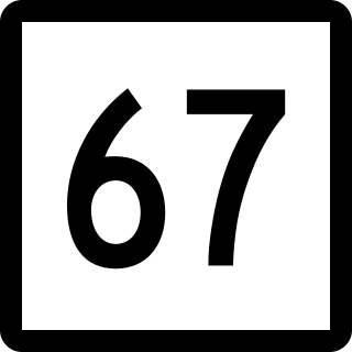
Route 67 is a secondary state highway in the U.S. state of Connecticut, from the town of New Milford in the Greater Danbury area to the town of Woodbridge in the outskirts of New Haven. The route runs for 31.00 miles (49.89 km). It generally follows a northwest-southeast path, and is signed north-south.

Ponders End is the southeasternmost part of Enfield, north London, centred on the Hertford Road. Situated to the west of the River Lee Navigation, it became industrialised through the 19th century, similar to the Lea Valley in neighbouring Edmonton and Brimsdown, with manufacturing giving way to warehousing in the late-20th century. The area features much social housing, with streets also lined with suburban terraced housing from the 19th and early 20th centuries.
Lower Edmonton railway station was a station in Edmonton, London opened in 1849 by the Eastern Counties Railway as part of the original Enfield Town branch line. Originally named Edmonton it was renamed as Lower Edmonton low level to distinguish it from neighbouring Lower Edmonton high level. It closed to passengers in 1939 although the line on which it stood lasted until 1964.

The Lillinonah Trail is a 5.9-mile (9.5 km) Blue-Blazed hiking trail "system" in the lower Housatonic River valley in Fairfield County and, today, is entirely in Newtown. Most of the trail is in the upper block of Paugussett State Forest.

The Zoar Trail is a 6.5-mile (10.5 km) Blue-Blazed hiking trail "system" in the lower Housatonic River valley in Fairfield County and is entirely in the Sandy Hook section of Newtown in the lower block of Paugussett State Forest.
The Kettletown Trails are a 4.6-mile (7.4 km) Blue-Blazed hiking trail "system" in the lower Housatonic River valley in Fairfield County and are in the towns of Southbury and Oxford -- primarily in the Kettletown State Park and the Jackson Cove recreation area belonging to the town of Oxford.

The Southbury Loop is a line linking Edmonton Green, in north-east London, to Cheshunt. It was opened by the Great Eastern Railway in 1891. Initially it was not very successful and was closed to passenger traffic in 1909. Goods trains continued to use the line and during World War I passenger services were reinstated for munitions workers. Once the war finished the line returned to its goods-only status although it was occasionally used for diversionary purposes when the West Anglia Main Line was closed south of Cheshunt. Electrification of the line and the reintroduction of passenger services in 1960 saw the line become busy with regular suburban services as part of the Lea Valley Lines network. Since May 2015 passenger services on the line are part of London Overground.
Carterhatch Lane Halt was a railway station built by the Great Eastern Railway in 1916 on the Southbury Loop line to the north east of London in the United Kingdom. The Southbury Loop line was reopened in 1915 for passenger services for munitions workers to access factories in the Lea Valley area however the line closed in 1919.

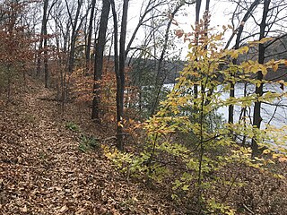
Audubon Center at Bent of the River is a 700-acre preserve in Southbury, Connecticut. It is located off South Britain Road and is open year-round.