
Geodesy is the Earth science of accurately measuring and understanding Earth's geometric shape, orientation in space, and gravitational field. The field also incorporates studies of how these properties change over time and equivalent measurements for other planets. Geodynamical phenomena include crustal motion, tides and polar motion, which can be studied by designing global and national control networks, applying space and terrestrial techniques and relying on datums and coordinate systems.

A retroreflector is a device or surface that reflects radiation back to its source with minimum scattering. This works at a wide range of angle of incidence, unlike a planar mirror, which does this only if the mirror is exactly perpendicular to the wave front, having a zero angle of incidence. Being directed, the retroflector's reflection is brighter than that of a diffuse reflector. Corner reflectors, and cat's eye reflectors are the most used kinds.
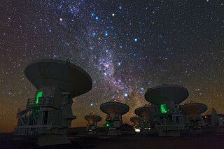
Very-long-baseline interferometry (VLBI) is a type of astronomical interferometry used in radio astronomy. In VLBI a signal from an astronomical radio source, such as a quasar, is collected at multiple radio telescopes on Earth or in space. The distance between the radio telescopes is then calculated using the time difference between the arrivals of the radio signal at different telescopes. This allows observations of an object that are made simultaneously by many radio telescopes to be combined, emulating a telescope with a size equal to the maximum separation between the telescopes.

In satellite laser ranging (SLR) a global network of observation stations measures the round trip time of flight of ultrashort pulses of light to satellites equipped with retroreflectors. This provides instantaneous range measurements of millimeter level precision which can be accumulated to provide accurate measurement of orbits and a host of important scientific data. The laser pulse can also be reflected by the surface of a satellite without a retroreflector, which is used for tracking space debris.
Satellite geodesy is geodesy by means of artificial satellites — the measurement of the form and dimensions of Earth, the location of objects on its surface and the figure of the Earth's gravity field by means of artificial satellite techniques. It belongs to the broader field of space geodesy. Traditional astronomical geodesy is not commonly considered a part of satellite geodesy, although there is considerable overlap between the techniques.
The National Space Institute at the Technical University of Denmark, also known as DTU Space, is a Danish sector research institute and a part of the Technical University of Denmark. It has a staff of 169, including researchers, engineers, and technicians.

A geodetic control network is a network, often of triangles, which are measured precisely by techniques of terrestrial surveying or by satellite geodesy.
Geodetic astronomy or astronomical geodesy (astro-geodesy) is the application of astronomical methods into geodetic networks and other technical projects of geodesy.
Ajisai is a Japanese satellite sponsored by NASDA, launched in 1986 on the first flight of the H-I rocket. It is also known as the Experimental Geodetic Satellite (EGS), as it carried the Experimental Geodetic Payload (EGP).

A medium Earth orbit (MEO) is an Earth-centred orbit with an altitude above a low Earth orbit (LEO) and below a high Earth orbit (HEO) – between 2,000 km (1,243 mi) and 35,786 km (22,236 mi) above sea level).
Stellar triangulation is a method of geodesy and of its subdiscipline space geodesy used to measure Earth's geometric shape. Stars were first used for this purpose by the Finnish astronomer Yrjö Väisälä in 1959, who made astrometric photographs of the night sky at two stations together with a lighted balloon probe between them.

The Space Research Centre is an interdisciplinary research institute of the Polish Academy of Sciences. It was established in 1977. SRC PAS is the only institute in Poland whose activity is fully dedicated to the research of terrestrial space, the Solar System and the Earth using space technology and satellite techniques.
The Bessel ellipsoid is an important reference ellipsoid of geodesy. It is currently used by several countries for their national geodetic surveys, but will be replaced in the next decades by modern ellipsoids of satellite geodesy.
The Geo-IK-2 is a Russian series of new generation military geodesy satellites replacing the Soviet Union's Geo-IK and Sfera constellations. They are intended to be used to create high precision three-dimensional maps of the Earth's surface, and to monitor plate tectonics. The satellites are produced by ISS Reshetnev, and have a mass of around 1,400 kilograms (3,100 lb). They operate in a circular orbit at an altitude of around 1,000 kilometres (620 mi) above the Earth's surface.

BLITS is a Russian satellite launched on September 17, 2009, as a secondary payload on a Soyuz-2.1b/Fregat, from the Baikonur Cosmodrome in Kazakhstan. The satellite is totally passive and spherical, and is tracked using satellite laser ranging (SLR) by the International Laser Ranging Service. The design of BLITS is based on the optical Luneburg lens concept. The retroreflector is a multilayer glass sphere; it provides uniform reflection characteristics when viewed within a very wide range of angles, and can provide a cross-section sufficient for observations at low to medium orbit heights. A similar design was already tested on a smaller laser reflector carried on board of the METEOR-3M spacecraft launched on December 10, 2001.

The Geodetic Observatory Wettzell is located atop the 616 meter-high mountain Wagnerberg, west of the village Wettzell in the German district Cham in the Bavarian Forest.

Sfera is a series of Soviet geodetic satellites.

The TUM Department of Aerospace and Geodesy is a department of the Technical University of Munich, located in Ottobrunn. It combines the field of aerospace engineering with research in satellite navigation, earth observation and the basic geodetic disciplines.
Starlette and Stella are nearly identical French geodetic and geophysical satellites. Starlette was launched on 6 February 1975 and Stella on 26 September 1993. Starlette was the first passive laser satellite developed.
