
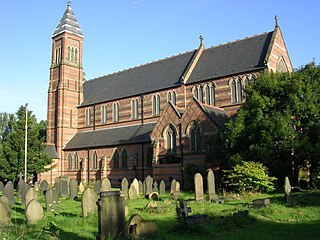
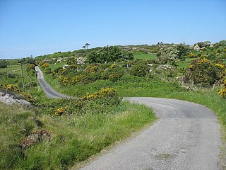
St Elidan's Church is a Grade II*-listed building in the community of Llanelidan in Denbighshire, Wales. [1]
St Elidan's Church is a Grade II*-listed building in the community of Llanelidan in Denbighshire, Wales. [1]
There are several long-established Nordic churches in London. All seek to provide Lutheran Christian worship and pastoral care to their respective national communities in their own languages. Many of the churches also organise language classes and organise a wide range of social activities.

Newland is a suburb of Kingston upon Hull, East Riding of Yorkshire, England, in the north-west of the city, a former village on the Hull to Beverley turnpike.
The Church of St Cross, Clayton, Manchester, is a Victorian church by William Butterfield, built in 1863–66. It was designated a grade II* listed building in 1963.

The Church of St Mary, Upper Moss Lane, Hulme, Manchester, is a Gothic Revival former church by J. S. Crowther built in 1853–58. It was designated a Grade II* listed building on 3 October 1974.
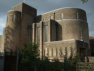
The Church of St Nicholas, Kingsway, Burnage, Manchester, is a Modernist church of 1930–2 by N. F. Cachemaille-Day, Lander and Welch. It was enlarged in 1964 with a bay on the west side, also by Cachemaille-Day. Pevsner describes the church as "a milestone in the history of church architecture in England". The church was designated a Grade II* listed building on 10 October 1980.

Nantclwyd Hall is a 17th-century Grade II* listed mansion near the village of Llanelidan, Denbighshire, Wales, built by the Parry family, and rebuilt by Eubule Thelwall and his wife Mary Parry, the heiress of the estate.

John Jones, (1854–1913) known as Coch Bach y Bala was a notorious Welsh criminal. His nickname, Coch Bach y Bala, literally translates as 'Little Redhead of Bala'. He is also known as the Welsh Houdini for having escaped on more than one occasion from Ruthin Gaol.
Rhyd-y-Marchogion was a farm in Llanelidan, Denbighshire. The farmhouse, attached cartshed, and garden wall as well as the farmyard buildings are Grade II listed buildings. Both the farmhouse and the farmyard buildings have now been converted into two separate homes.
The Leyland Arms is a Grade II listed building in the community of Llanelidan near Ruthin, Denbighshire, Wales, which dates back to 1354. It was listed by Cadw.

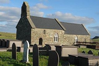
St Dyfnan's Church is a medieval church in the village of Llanddyfnan, Anglesey, Wales. The building dates from the 14th century and underwent extensive renovations in the mid-19th century. The church lies north from the B5109 road. It was designated as a Grade II*-listed building on 5 December 2007.

St Morhaiarn's Church is a medieval church in the village of Gwalchmai in Anglesey, Wales. The building dates from the 14th century and underwent extensive renovations in 1845 by Reverend J. Wynne Jones. It was designated a Grade II*-listed building on 4 May 1971.
St Rhwydrus's Church is a medieval church in the village of Cemlyn on the Isle of Anglesey, Wales. The building dates from the mid-12th century and underwent renovations in the 19th century. It was designated a Grade II*-listed building on 5 December 1970.

St Catherine's Church is a church in the village of Llanfaes, Anglesey, Wales. The building dates from the 19th century. It was designated as Grade II-listed building on 20 February 1978.

St Cawrdaf's Church is a church in the village of Llangoed, Isle of Anglesey, Wales. The building dates from the 17th century and underwent renovations in the 19th century. It was designated a Grade II-listed building on 30 January 1968.

St Cyngar's Church is a church in the town of Llangefni in Anglesey, Wales. The building dates from 1824. It was designated a Grade II listed building on 8 July 1952.

St Maelog's Church is a church in the village of Llanfaelog, situated in the Isle of Anglesey, Wales. The present building dates from the 19th century. It was designated as a Grade II listed building on 4 May 1971.
Mechell is a community in the north of the Isle of Anglesey, Wales. Llanfechell is the largest village within the community area. Tregele, Llanfflewyn, Mynydd Mechell, Bodewryd, Rhosbeirio and Carreglefn have a more dispersed settlement pattern. The antiquity of these settlements is shown by the presence of 6 medieval churches and some 16 more ancient sites dating back into prehistory.
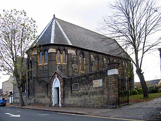
St Nicholas' Chapel, Manor Park is a Roman Catholic church in Manor Park, east London.
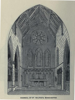
St Wilfrid's Church in George Street, Hulme, Manchester, England, was a Roman Catholic place of worship. Designed by Augustus Pugin, it was his only known church building in that city.
Llannerch was a commote in the cantref of Dyffryn Clwyd which later became the Marcher Lordship of Ruthin. Situated in an area south of Ruthin the commote covered an area of 9,000 acres which included the parishes of Llanfair Dyffryn Clwyd and Llanelidan and 19 townships. Much of the land within the commote was owned by the Bishopric of Bangor.
Coordinates: 53°02′41″N3°19′45″W / 53.0447°N 3.3292°W
| | This article about a Denbighshire building or structure is a stub. You can help Wikipedia by expanding it. |