
The village of Hartland, whose parish incorporates the hamlet of Stoke to the west and the village of Meddon in the south, is the most north-westerly settlement in the county of Devon, England.

Thornbury is a small village and civil parish in the local government district of Torridge, Devon, England. The parish, which lies about five miles north-east of the town of Holsworthy, comprises the five hamlets of Thornbury, Woodacott, Brendon, Lashbrook and South Wonford. These five hamlets are spread over an area of some 6 square miles, with a distance of 3 miles from Brendon to Thornbury Church. Hence, the community is quite widespread, with the only focal point being the Green at Woodacott Cross. The parish is surrounded clockwise from the north by the parishes of Milton Damerel, Bradford, Cookbury and Holsworthy Hamlets. In 2011 its population was 290, in 120 households, little changed from the 291 residents it had in 1901.

Beaford is a village and civil parish in the Torridge district of Devon, England. The village is about five miles south-east of Great Torrington, on the A3124 road towards Exeter. According to the 2001 census the parish had a population of 393, compared to 428 in 1901. The western boundary of the parish is formed by the River Torridge and it is surrounded, clockwise from the north, by the parishes of St Giles in the Wood, Roborough, Ashreigney, Dolton, Merton and Little Torrington.

Yarnscombe is a small village and parish in the Torridge area of Devon, England. It is situated approximately 5 miles (8 km) from Great Torrington and 8 miles (13 km) from Barnstaple. In the year 2001 census the population was recorded at 300.
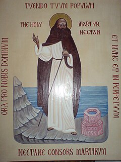
Saint Nectan, sometimes styled Saint Nectan of Hartland, was a 5th-century holy man who lived in Stoke, Hartland, in the English county of Devon, where the prominent Church of Saint Nectan, Hartland is dedicated to him.
St Giles in the Wood is a village and civil parish in the Torridge district of Devon, England. The village lies about 2.5 miles east of the town of Great Torrington, and the parish, which had a population of 566 in 2001 compared with 623 in 1901, is surrounded clockwise from the north by the parishes of Huntshaw, Yarnscombe, High Bickington, Roborough, Beaford, Little Torrington and Great Torrington. Most of the Victorian terraced cottages in the village, on the east side of the church, were built by the Rolle Estate.

St Winnow is a civil parish in Cornwall, England, United Kingdom. Its name may be connected with either that of Saint Winnoc or Saint Winwaloe. It has a population of 304, which had increased to 328 at the 2011 census. The church town is on the east bank of the River Fowey south of Lostwithiel. Part of the village of Lerryn lies within the parish as does the Chapel of St Nectan. The Redlake Meadows & Hoggs Moor, a Site of Special Scientific Interest is also in the parish.

Cheriton Bishop is a village and civil parish situated on the northern borders of Dartmoor National park between Exeter and Okehampton, in Devon, England. The population at the 2011 Census was 652. The history of the settlement can be traced back over a thousand years when the old village centre was established as a commercial centre for the local farming community.
The Church of St Nectan is the parish church of Hartland, Devon, England. Sometimes referred to as the "Cathedral of North Devon", it is located in the hamlet of Stoke, about 1.5 miles (2.4 km) west of the town of Hartland. It is dedicated to Saint Nectan.

Staverton is a village and civil parish in the South Hams of Devon, England consisting of 297 households and a population of 717.
The Deanery of Hartland represents the Church of England in the north west corner of Devon within the Archdeaconry of Barnstaple and the Diocese of Exeter.
Tetcott is a civil parish, small settlement and former manor in Devon, England. The parish lies about five miles south of the town of Holsworthy and is bordered on the north by the parish of Clawton, on the east by a small part of Ashwater, and on the south by Luffincott. It forms part of the local government district of Torridge, and its western boundary is the River Tamar which forms the Cornish border. In 2001 its population was 110, half that of a century earlier.

Northleigh is a village and civil parish in the East Devon district of Devon, England. Its nearest town is Colyton, which lies approximately 3.5 miles (5.6 km) south-east from the village.

Pancrasweek is a civil parish and hamlet in the far west of Devon, England forming part of the local government district of Torridge and lying about three miles north west of the town of Holsworthy.

East Putford is a small settlement and civil parish in the local government district of Torridge, Devon, England. The parish, which lies about halfway between the towns of Holsworthy and Bideford, is surrounded clockwise from the north by the parishes of Parkham, Buckland Brewer, Bulkworthy, West Putford, and Woolfardisworthy. In 2001 its population was 103, slightly lower than the 125 residents it had in 1901.

West Putford is a small settlement and civil parish in the local government district of Torridge, Devon, England. The parish, which lies about 8.5 miles north of the town of Holsworthy, is surrounded clockwise from the north by the parishes of East Putford, a small part of Bulkworthy, Abbots Bickington, Sutcombe, Bradworthy and Woolfardisworthy. In 2001 its population was 181, compared to 216 in 1901. The eastern and northern boundaries of the parish mostly follow the River Torridge over which is the 13th-century Kismeldon Bridge. Tumuli on the high ground provide evidence for early inhabitants here.

Loxhore is a small village, civil parish and former manor in the local government district of North Devon in the county of Devon, England. The parish, which lies about five miles north-east of the town of Barnstaple, is surrounded clockwise from the north by the parishes of Arlington, Bratton Fleming and Shirwell. In 2001 its population was 153, down from the 202 residents it had in 1901.

St Peter's Church is the parish church of the town of Barnstaple in North Devon, England. Parts of the church date to the 13th-century with much restoration during the Victorian era by George Gilbert Scott and later by his son John Oldrid Scott which changed the atmosphere of the building, although many fine wall monuments and tablets remain. The church comes under the Diocese of Exeter.


