The Line of Actual Control (LAC), in the context of the Sino-Indian border dispute, is a notional demarcation line that separates Indian-controlled territory from Chinese-controlled territory. The concept was introduced by Chinese premier Zhou Enlai in a 1959 letter to Jawaharlal Nehru as the "line up to which each side exercises actual control", but rejected by Nehru as being incoherent. Subsequently, the term came to refer to the line formed after the 1962 Sino-Indian War.
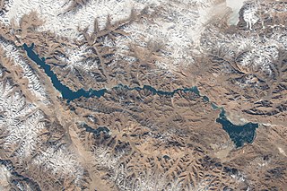
Pangong Tso or Pangong Lake is an endorheic lake spanning eastern Ladakh and West Tibet situated at an elevation of 4,225 m (13,862 ft). It is 134 km (83 mi) long and divided into five sublakes, called Pangong Tso, Tso Nyak, Rum Tso and Nyak Tso. Approximately 50% of the length of the overall lake lies within Tibet administered by China, 40% in Ladakh, India and the remaining 10% is disputed and is a de facto buffer zone between India and China. The lake is 5 km (3.1 mi) wide at its broadest point. All together it covers almost 700 km2. During winter the lake freezes completely, despite being saline water. It has a land-locked basin separated from the Indus River basin by a small elevated ridge, but is believed to have been part of the latter in prehistoric times.

Ladakh is an administrative territory of India that has been under its control since 1947. The geographical region of Ladakh union territory is the highest altitude plateau region in India, incorporating parts of the Himalayan and Karakoram mountain ranges and the upper Indus River and valley.

Tourism is one of an economic contributor to the union territory of Ladakh in Northern India. The union territory is sandwiched between the Karakoram mountain range to the north and the Himalayas to the south and is situated at the height of 11,400 ft. Ladakh is composed of the Leh and Kargil districts. The region contains prominent Buddhist sites and has an ecotourism industry.
Rechin La , which was called Rezang La in the English language sources in the 1960s, is a mountain pass on the Line of Actual Control between Indian-administered Ladakh and the Chinese-administered Spanggur Lake basin. The pass is located on the watershed ridge of the Chushul Valley, on its east. China claims that the ridge is the boundary between the two countries, but India's claim line is further east.
The Sino–Indian border dispute is an ongoing territorial dispute over the sovereignty of two relatively large, and several smaller, separated pieces of territory between China and India. The first of the territories, Aksai Chin, is administered by China and claimed by India; it is mostly uninhabited high-altitude wasteland but with some significant pasture lands at the margins. It lies at the intersection of Kashmir, Tibet and Xinjiang, and is crossed by China's Xinjiang-Tibet Highway; the other disputed territory is south of the McMahon Line, in the area formerly known as the North-East Frontier Agency and now a state called Arunachal Pradesh. It is administered by India and claimed by China. The McMahon Line was signed between British India and Tibet to form part of the 1914 Simla Convention, but the latter was never ratified by China. China disowns the McMahon Line agreement, stating that Tibet was not independent when it signed the Simla Convention.
Chushul is a village in the Leh district of Ladakh, India. It is located in the Durbuk tehsil, in the area known as "Chushul Valley", south of the Pangong Lake and west of the Spanggur Lake. The Line of Actual Control with China runs about 5 miles east of Chushul, across the Chushul Valley. Famous as site for historical battle grounds.

The Khurnak Fort is a ruined fort on the northern shore of Pangong Lake, which spans eastern Ladakh in India and Rutog County in the Tibet region of China. The area of the Khurnak Fort is disputed by India and China, and has been under Chinese administration since 1958.
The Galwan River flows from the disputed Aksai Chin area administered by China to the Union Territory of Ladakh, India. It originates near the caravan campsite Samzungling on the eastern side of the Karakoram range and flows west to join the Shyok River. The point of confluence is 102 km south of Daulat Beg Oldi. Shyok River itself is a tributary of the Indus River, making Galwan a part of the Indus River system.
Spanggur Tso, also called Maindong Tso, Mendong Tso, is a saltwater lake in Rutog County in the Tibet Autonomous Region of China, close to the border with Ladakh. India claims a major portion of the lake as its own territory, as part of Ladakh. To the west of the lake lies the Spanggur Gap, a low pass through which the Line of Actual Control runs. To the north is the much larger lake Pangong Tso. Spanggur Tso is at an elevation of 4305 meters, and has an area of 61.6 square kilometres. The lake's average annual temperature is around -4 to -2 °C, and the annual precipitation is 50 to 75 mm. The western portion of the lake is claimed by India.

Gurung Hill is a mountain near the Line of Actual Control between the Indian- and Chinese-administered portions of Ladakh near the village of Chushul and the Spanggur Lake. As of 2020, the Line of Actual Control runs on the north–south ridgeline of Gurung Hill. To the west of Gurung lies the Chushul valley and to the right of it are mountains of Kailash Range forming the basins of the Spanggur Lake and the Pangong Lake in this area.
Tangtse or Drangtse (Tibetan: བྲང་རྩེ, Wylie: brang rtse, THL: drang tsé) is a village in the Leh district of Ladakh, India. It is located in the Durbuk tehsil. Traditionally, it was regarded as the border between the Nubra region to the north and the Pangong region to the south. It was a key halting place on the trade route between Turkestan and Tibet. It was also a site of wars between Ladakh and Tibet.
Durbuk or Darbuk, is a village and the headquarters of the eponymous subdivision and block in the Leh district of Ladakh, India. It is located in the Durbuk tehsil, and falls between Chang La mountain pass and Tangste village on the way to Pangong Tso Lake.

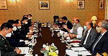
Border Personnel Meeting points are locations along the disputed Sino-Indian territories on Line of Actual Control (LAC) where the armies of both countries hold ceremonial and practical meetings to resolve border issues and improve relations. While border meetings have been held since the 1990s, the first formal Border Personnel Meeting point was established in 2013. There are five meeting points: two in the Indian Union Territory of Ladakh, one in Sikkim, and two in Arunachal Pradesh in India's Central and Eastern sectors.
2020s in history refers to significant political and societal historical events of the 2020s, presented as a historical overview in narrative format.

Beginning on 5 May 2020, Chinese and Indian troops engaged in aggressive melee, face-offs, and skirmishes at locations along the Sino-Indian border, including near the disputed Pangong Lake in Ladakh and the Tibet Autonomous Region, and near the border between Sikkim and the Tibet Autonomous Region. Additional clashes also took place at locations in eastern Ladakh along the Line of Actual Control (LAC).
The Chinese order of battle in the 2020–2021 China–India skirmishes.
Indian order of battle during the 2020–2021 China–India skirmishes:
Gogra (also referred to as Nala Junction) is a pasture and campsite in the Ladakh union territory of India, near the Line of Actual Control with China. It is located in the Kugrang River valley, a branch valley of Chang Chenmo Valley, where the Changlung River flows into Kugrang. During the times of the British Raj, Gogra was a halting spot for travellers to Central Asia via the 'Chang Chenmo route', who proceeded through the Changlung river valley and the Aksai Chin plateau.
Jianan Pass is a mountain pass in the eastern Karakoram Range near the Chang Chenmo Valley. The Line of Actual Control (LAC) between India and China runs through the pass dividing the Indian-administered Ladakh and Chinese-administered Aksai Chin. The pass lies on the watershed between Kugrang and Galwan river basins. The Changlung river basin is also immediately to the east of the pass. While China uses the name "Jianan Daban" for the pass, India refers to it as Patrol Point 15 (PP-15) for border security purposes. The term "Hot Springs" has also been used by Indian media through misapplication of terminology.