Wharepapa / Arthur Range

Last updated

Wharepapa / Arthur Range
Arthur Range 03.jpg
Wharepapa / Arthur Range as viewed from the Waimea Plains.
Highest point
PeakNorth Twin
Elevation 1,809 m (5,935 ft) [1]
Coordinates 41°13′05″S172°40′55″E / 41.218°S 172.682°E / -41.218; 172.682 [2]
Dimensions
Length55 km (34 mi)Northeast-Southwest [1]
Width16 km (9.9 mi)Northwest-Southeast [1]
Naming
Etymology After Tuao Wharepapa and Arthur Wakefield. [3]
Native nameWharepapa (Māori)
Geography
New Zealand relief map.jpg
Red triangle with thick white border.svg
Location in New Zealand
CountryFlag of New Zealand.svg  New Zealand
Region Tasman, West Coast [4]
Range coordinates 41°14′02″S172°39′36″E / 41.234°S 172.660°E / -41.234; 172.660 [5]
Geology
Formed by Tectonic uplift / glaciation

The Wharepapa / Arthur Range is a mountain range partially marking the boundary between the Tasman District and West Coast Region of New Zealand's South Island. The range is at the eastern extent of the Tasman Mountains which make up much of the island's northwest, making it easily visible from across the low-lying Waimea Plains further to the east. The range's location and its many uses make it a significant site for local Māori, including the iwi of Te Ātiawa and Ngāti Rārua. This includes the prominent peaks of Mount Arthur and Pukeone / Mount Campbell, which both hold mana in their own right and have become part of the identity of the aforementioned iwi. [6]

Contents

The mountains of Wharepapa / Arthur Range have a complex geological history, with most of their rocks dating to the Ordovician and having been transformed several times before being uplifted to their current position. The range is also notable for the vast networks of caves beneath its surface, including several of the deepest caves in New Zealand. These caves have developed as an excellent record of climatic and ecological conditions, with fossils or sub-fossils of dozens of native birds having been found, some of which are either extinct or no longer found in the region.

Despite early economic use, the conservation value of the range continues to be high, and during the late 1980s and early 1990s the area was a core part of efforts to establish a national park in the island's northwest. This culminated in the establishment of Kahurangi National Park in 1996, which continues to protect the Wharepapa / Arthur Range to this day.

Geography

Wharepapa / Arthur Range, as viewed from near the summit of Mount Arthur Mount Arthur Range.jpg
Wharepapa / Arthur Range, as viewed from near the summit of Mount Arthur

As with many of New Zealand's mountain ranges, the Wharepapa / Arthur Range has been formed by millions of years of tectonic uplift. This has taken place through at least two major periods of tectonic activity; one prior to the Cenozoic and another in the late Cenozoic. [7] The history of uplift and other transformation has given the range a wide variety of intermingled rock, with the oldest dating to between the Cambrian and Devonian periods some of the oldest rocks found anywhere in New Zealand. [8] The majority of the range, however, is made up of crystalline marble from the Ordovician, interbedded with occasional intrusive volcanic material from past activity in the region. [7] Portions of the range and its surrounding area, such as the Tablelands, were formed by the eroded remnants of limestone deposits on a sea-level plain during the Eocene. [9]

The mixed composition of the range has resulted in the formation of extensive cave systems, including the Nettlebed Cave and Ellis Basin cave system, which are the deepest known cave systems in New Zealand at explored depths of 889 metres (2,917 ft) and 1,024 metres (3,360 ft) respectively. [10] The Pearse Resurgence, where the Pearse River emerges from caves underneath the Wharepapa / Arthur Range, is an exit point for many of these systems and has been the site of several cave dives one of which became the deepest cave dive ever completed in New Zealand in 2016, before being beaten by another dive in the Pearse Resurgence in 2020. [11] [12] Speleothems in the caves of the range have been used to identify the impact which vegetation density has on flowstone growth, which found that there is faster growth during warmer periods with denser vegetation on the mountains. [13]

During the last glacial maximum, the Wharepapa / Arthur Range was home to multiple glaciers, though not to the extent of nearby ranges. Unlike the extensive glacier system of the Cobb valley to the west of the range and the glacially-formed landforms present in the Peel Range, the extent of glaciation in the Wharepapa / Arthur Range was limited to small glaciers around the peaks of Mount Arthur and the Twins. [14] On Mount Arthur, these glaciers formed cirques which polished the marble surfaces of the range. These cirques now feature several sinkholes, as a result of the extensive cave systems within the range. [9]

History

Wharepapa / Arthur Range has had a long history of human interaction, both before and after Pākehā settlement of New Zealand. The range is known to local Māori as Wharepapa, a name it shares with Mount Arthur (Tu Ao Wharepapa in Māori). This is said to have originated with a local rangatira, who named the range and peak after a woman whom he fell in love with. [3] Oral traditions of Ngāti Tama hold Wharepapa as an ancestor, with the mountain itself providing a link to the spirits. [5] Similarly, both Tu Ao Wharepapa and Pukeone within the range are sacred to Ngāti Rārua, as are several of the caves within the range. [5] Due to its visibility across the area, Pukeone was used as a location to light signal fires to convey news or signal important events, such as when Arthur Wakefield accepted the location of Nelson to found a settlement. [6]

During the mid-19th century, the Nelson Provincial Council commissioned Arthur Dudley Dobson to explore the mountains on their behalf. Dobson named the range and its most prominent peak after Captain Arthur Wakefield, who had been heavily involved in the establishment of Nelson on behalf of the New Zealand Company. [15] As the settlement of Nelson expanded, the colonists began exploring for more grazing land and resources to help develop Nelson's economy. Rumours of a vast expanse of tussockland beyond the Arthur Range led to the discovery of the Tablelands by Thomas Salisbury, a settler in search of pastureland. [3] After early use for raising livestock by Salisbury and his brothers, gold was discovered on the Tablelands of the range. This spurred a small gold rush, although conditions in the tablelands and their relative remoteness for the quantity of gold hindered major development. [3] Sporadic exploration for further mineral deposits across the range continued late into the 20th century, however none developed into industrial operations. [7] A proposal by an Australian mining company to construct a road into the region and open it for mining in 1981 was met with swift opposition, becoming a catalyst for the designation of the region as a national park 15 years later. [16]

In contrast to the relative lack of success from mineral prospectors, the mountain range proved far more valuable to tourism operators. As early as the 1880s, groups of tourists were venturing into the region, using the few huts in the area as bases from which to explore on day trips. [3] As tourism operators gradually became established, there was talk of further development a ski field was proposed on the slopes of Mount Arthur in 1937, though access issues saw this fall through in favour of mountains in the Nelson Lakes area which could be more easily reached. [3]

By the 1940s, calls were being made to protect the Arthur Range and other mountainous terrain in the region as conservation land, such as through an expansion to Abel Tasman National Park. The land was eventually protected as part of North West Nelson Forest Park, however frequent proposals for development highlighted the inadequacy of this protection. [16] Throughout the 1980s and 1990s, conservation groups lobbied for the northwest of the South Island to be designated as a national park. This was eventually successful, with much of the former forest park including the Arthur Range forming the new Kahurangi National Park in 1996. [16] The range remains protected as part of the national park to this day, and is a popular tramping destination. [17]

In 2014, to recognise the significance of the range to local Māori, the range became one of hundreds of geographic features in New Zealand to be given an official dual name. [5] The name was established through a Treaty of Waitangi settlement between Ngāti Kōata and the Crown, along with several other dual names in the same area. [18]

Ecology

Fossils and sub-fossils of at least 20 species of birds dating to the Pleistocene and Holocene have been found in the Hodges Creek cave system, providing a window into the pre-human ecosystem of the region. Bones found include extinct species such as the Haast's eagle, Finsch's duck, and various types of moa, as well as extant species no longer found in the area, such as takahē, and kākāpō. [19] The frequency at which takahē and Finsch's ducks remains are found within the cave's fossil record suggests that these species were among the most common ground birds in the area during the late Pleistocene, around 12,000 years ago. [19] The caves are also home to troglobites, such as spiders and amphipods, which continue to be discovered as the caves are progressively explored. [20]

Above the surface, the Wharepapa / Arthur Range is home to a wide range of plant and animal species, with 86 different species either threatened or at risk found on the range. [14] Plant species found across the range include a variety of herbs, shrubs and grasses associated with the alpine tussock grasslands of the Tablelands, through to podocarp forests, southern rātā, kāmahi and occasional patches of mānuka scrub. Several nationally critical or endangered plants can also be found on the range, including species from Ourisia , Pittosporum , Botrychium and Melicytus among others. [14]

As with much of New Zealand's forests, birds are the most prominent wildlife across the mountain range. The species found on the range are largely typical of that in the rest of the island, with alpine birds such as the kea and New Zealand rock wren recorded in the area, as well as more common lowland species such as the kākā, New Zealand falcon and fernbird. Although the roroa (great spotted kiwi) disappeared from the Wharepapa / Arthur Range 30 years ago, a breeding population was reintroduced to the region in 2010. [21] The critically endangered New Zealand long-tailed bat is also believed to inhabit the range, but sightings have been infrequent since the 1970s. [14]

Several species of geckos and skinks are also found across the mountains. In 1998, Mount Arthur was found to be home to a population of black-eyed geckos, an alpine species previously thought to only inhabit the Kaikōura Ranges 120 kilometres (75 mi) to the east. [22] The discovery of a second population of the geckos at such a distance from the first improved the conservation prospects of the species, as did the apparent lack of any threats at Mount Arthur to the lizard. A separate species of gecko from the genus Woodworthia is restricted to the Wharepapa / Arthur Range and other nearby mountain ranges, one of several formerly grouped as regional populations of the common gecko. [23]

Related Research Articles

<span class="mw-page-title-main">Nelson, New Zealand</span> City in the South Island, New Zealand

Nelson is a city on the eastern shores of Tasman Bay / Te Tai-o-Aorere. It is the oldest city in the South Island and the second-oldest settled city in New Zealand; it was established in 1841 and became a city by royal charter in 1858.

<span class="mw-page-title-main">Tasman District</span> Government district of New Zealand

Tasman District is a local government district in the northwest of the South Island of New Zealand. It borders the Canterbury Region, West Coast Region, Marlborough Region and Nelson City. It is administered by the Tasman District Council, a unitary authority, which sits at Richmond, with community boards serving outlying communities in Motueka and Golden Bay / Mohua. The city of Nelson has its own unitary authority separate from Tasman District, and together they comprise a single region in some contexts, but not for local government functions or resource management (planning) functions.

<span class="mw-page-title-main">Nelson Lakes National Park</span> National park in New Zealand

Nelson Lakes National Park is in the South Island of New Zealand, at the northern end of the Southern Alps. It was formed after the passing of the National Parks Act in 1952. It was created in 1956. The park contains beech forests, multiple lakes, snow-covered mountains and valleys created by glaciers during the ice ages.

<span class="mw-page-title-main">Kahurangi National Park</span> National park in New Zealand

Kahurangi National Park in the northwest of the South Island of New Zealand is the second largest of the thirteen national parks of New Zealand. It was gazetted in 1996 and covers 4,529 square kilometres (1,749 sq mi), ranging to near Golden Bay in the north. Much of what was the North-west Nelson Forest Park formed the basis of the new park. Kahurangi Point, regarded as the boundary between the West Coast and Tasman Regions, is located in the park, as is Mount Owen. The main tramping tracks in the park are the Heaphy Track and the Wangapeka Track.

<span class="mw-page-title-main">Stephens Island (New Zealand)</span> Island of the Marlborough Sounds, New Zealand

Stephens Island is at the northernmost tip of the Marlborough Sounds in the South Island of New Zealand. It lies two kilometres to the northeast of Cape Stephens, the northernmost point of D'Urville Island. The island is 1.5 square kilometres in size, and rises 283 metres (928 ft) high from the sea.

<span class="mw-page-title-main">Cable Bay</span>

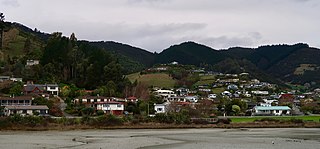
Rotokura / Cable Bay is a bay and small settlement 18 kilometres (11 mi) north-east of Nelson in New Zealand. The settlement at the head of the bay is at the southern end of a thin strip of land or causeway connecting Pepin Island with the South Island.

<i>Spelungula</i> Genus of spiders

Spelungula is a monotypic genus of South Pacific large-clawed spiders containing the single species, Spelungula cavernicola, or the Nelson cave spider. It was first described by Ray Forster, Norman I. Platnick, & Michael R. Gray in 1987, and has only been found in caves in the northwestern part of New Zealand's South Island.

<span class="mw-page-title-main">Ngāti Koata</span> Māori iwi in New Zealand

Ngāti Koata or Ngāti Kōata is a Māori iwi of New Zealand, originating on the west coast of Waikato, but now mainly at the northern tip of South Island.

<span class="mw-page-title-main">Rangitāne</span> Māori iwi in New Zealand

Rangitāne is a Māori iwi (tribe). Their rohe (territory) is in the Manawatū, Horowhenua, Wairarapa and Marlborough areas of New Zealand.

<span class="mw-page-title-main">Pearse River</span> River in New Zealand

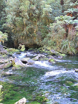
The Pearse River is a river of the Tasman Region of New Zealand's South Island. It flows east from sources in the Wharepapa / Arthur Range, reaching the Motueka River 20 kilometres southwest of Motueka.

<span class="mw-page-title-main">Golden Bay / Mohua</span> Bay in New Zealand

Golden Bay / Mohua is a shallow, paraboloid-shaped bay in New Zealand, near the northern tip of the South Island. An arm of the Tasman Sea, the bay lies northwest of Tasman Bay / Te Tai-o-Aorere and Cook Strait. It is protected in the north by Farewell Spit, a 26 km long arm of fine golden sand that is the country's longest sandspit. The Aorere and Tākaka rivers are the major waterways to flow into the bay from the south and the west.

<span class="mw-page-title-main">Mount Arthur (New Zealand)</span> Mountain in New Zealand

Mount Arthur is in the Wharepapa / Arthur Range in the north western area of the South Island of New Zealand. Mount Arthur, named after Captain Arthur Wakefield, lies within Kahurangi National Park and has a peak elevation of 1,795 metres (5,889 ft).

<span class="mw-page-title-main">Kakepuku</span>

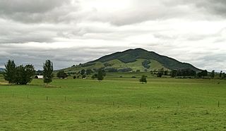
Kakepuku is a volcanic cone which rises from the plain between the Waipā and Puniu rivers, about 3 km (2 mi) NW of Te Kawa and 8 km (5 mi) SW of Te Awamutu in the Waikato region of New Zealand's North Island.

<span class="mw-page-title-main">Atawhai</span> Suburb of Nelson, New Zealand

Atawhai is a suburb of Nelson, New Zealand. It lies north of Nelson and is the location of Wakapuaka Cemetery, a burial place since 1861. It also has a coastline on Nelson Haven and access to Boulder Bank from State Highway 6.

Te Atiawa o Te Waka-a-Māui is a Māori iwi (tribe) in the upper South Island of New Zealand. Its rohe extends from Golden Bay and Marlborough Sounds at the top of the South Island to Cape Campbell, St Arnaud and Westport.

Waipounamu Māori are a group of Māori iwi at or around the South Island of New Zealand. It includes the iwi (tribe) of Ngāi Tahu and the historical iwi of Kāti Māmoe and Waitaha, who occupy the island except for its most northern districts. It also includes Te Tau Ihu Māori iwi, such as Ngāti Toa, Te Atiawa o Te Waka-a-Māui, Ngāti Apa ki te Rā Tō, Rangitāne, Ngāti Kuia, Ngāti Rārua, Ngāti Kōata and Ngāti Tama.

Wharepapa South is a rural community in the Waipa District and Waikato region of New Zealand's North Island. It is located west of Putāruru and east of Te Awamutu.

Ngāti Tūmatakōkiri is a Māori iwi (tribe) of New Zealand, who arrived on the Kurahaupō waka. In the 1600s the iwi settled northwestern South Island, becoming a major power in the region until the 1800s. In 1642, members of Ngāti Tūmatakōkiri made the first known contact between Europeans and Māori, when Dutch explorer Abel Tasman visited Golden Bay / Mohua.

<span class="mw-page-title-main">Westhaven (Te Tai Tapu) Marine Reserve</span>

Westhaven Marine Reserve is a marine reserve covering an area of 536 hectares in the Whanganui Inlet at the top of New Zealand's South Island. It was established in 1994 and is administered by the Department of Conservation.

Maniniaro / Angelus Peak is a mountain in Nelson Lakes National Park, near the northwestern extent of New Zealand's main divide. Although it is not the tallest peak in the Angelus Ridge or the wider Travers Range, Maniniaro remains a popular tramping destination and is significant to the Ngāti Apa ki te Rā Tō iwi, who claim mana whenua within the area. According to Ngāti Apa ki te Rā Tō beliefs, the mountain is intrinsically linked with nearby Rotomaninitua / Lake Angelus, with the two both said to represent the footprints of the iwi's ancestors as they embarked on their journey back to Hawaiki. It is also near both major lakes of the national park, being roughly 6 kilometres (3.7 mi) from the southern ends of both Lakes Rotoiti and Rotoroa.

References

  1. 1 2 3 "Wharepapa / Arthur Range". NZTopoMap. Land Information New Zealand Toitū Te Whenua. Retrieved 22 December 2022.
  2. "Place name detail: Mount Arthur". New Zealand Gazetteer. New Zealand Geographic Board . Retrieved 22 December 2022.
  3. 1 2 3 4 5 6 "Mount Arthur and the Tableland". www.theprow.org.nz. Retrieved 22 December 2022.
  4. "Regional Council 2022 boundaries (generalised)". datafinder.stats.nz. Statistics New Zealand Taturanga Aotearoa. Retrieved 22 December 2022.
  5. 1 2 3 4 "Place name detail: Wharepapa / Arthur Range". New Zealand Gazetteer. New Zealand Geographic Board . Retrieved 18 April 2022.
  6. 1 2 "Te ipukarea – The maunga are here". nrait.co.nz. Ngāti Rārua Ātiawa Iwi Trust. Retrieved 23 December 2022.
  7. 1 2 3 Johnston, M. R. (January 1974). "Geology of the Mount Arthur district, North-west Nelson". New Zealand Journal of Geology and Geophysics. 17 (1): 75–92. doi: 10.1080/00288306.1974.10427990 . Retrieved 23 December 2022.
  8. "Stratigraphy". GNS Science Te Pῡ Ao. Retrieved 23 December 2022.
  9. 1 2 "Cobb Valley, Mt Arthur, Tableland" (PDF). Department of Conservation Te Papa Atawhai. Retrieved 23 December 2022.
  10. Frankham, James. "What Lies Beneath". New Zealand Geographic. Kōwhai Media. Retrieved 23 December 2022.
  11. Silverwood, Neil. "Finding the Dark". wildernessmag.co.nz. Wilderness. Retrieved 23 December 2022.
  12. "The Pearse Resurgence". seacraft.eu. Seacraft. 14 July 2020. Retrieved 23 December 2022.
  13. Hellstrom, John; Sniderman, Kale; Drysdale, Russell; Couchoud, Isabelle; Hartland, Adam; Pearson, Andrew; Bajo, Petra (12 February 2020). "Speleothem growth intervals reflect New Zealand montane vegetation response to temperature change over the last glacial cycle". Scientific Reports. 10 (1): 2492. doi: 10.1038/s41598-020-58317-8 . ISSN   2045-2322. PMC   7015920 . PMID   32051432.
  14. 1 2 3 4 Toy, Sandy. "Biodiversity treasures of the Flora: A stocktake of the ecological values of the Salisbury Ecological Management Unit and the threats they face" (PDF). fof.org.nz. Friends of Flora and the Department of Conservation. Retrieved 23 December 2022.
  15. "Place name detail: Arthur Range". New Zealand Gazetteer. New Zealand Geographic Board . Retrieved 24 December 2022.
  16. 1 2 3 Hindmarsh, Gerard. "Kahurangi: Our Newest National Park". New Zealand Geographic. Kōwhai Media. Retrieved 24 December 2022.
  17. "Mount Arthur area". www.doc.govt.nz. Department of Conservation Te Papa Atawhai. Retrieved 24 December 2022.
  18. "Deed of Settlement of Historic Claims" (PDF). Ngāti Kōata and Te Pātaka a Ngāti Kōata and The Crown. Retrieved 24 December 2022.
  19. 1 2 Worthy, Trevor (1997). "Fossil deposits in the Hodges Creek Cave System, on the northern foothills of Mt Arthur, Nelson, South Island, New Zealand". Notornis. 44 (2): 111–124. Retrieved 23 December 2022.
  20. "Pearse Resurgence Cave Dive". NIWA. 6 November 2013. Retrieved 24 December 2022.
  21. "Roroa". www.fof.org.nz. Retrieved 24 December 2022.
  22. Whitaker, Tony; Shaw, Tim; Hitchmough, Rod. "Black-eyed geckos (Hoplodactylus kahutarae) on Mt Arthur, Kahurangi National Park" (PDF). doc.govt.nz. Department of Conservation Te Papa Atawhai. Retrieved 24 December 2022.
  23. "Woodworthia "Mt Arthur"". www.reptiles.org.nz. Retrieved 24 December 2022.