Woodmont | |
|---|---|
| Country | United States |
| District | Washington, D.C. |
| Ward | Ward 3 |
| Government | |
| • Councilmember | Mary Cheh |
Woodmont is a neighborhood in northwest Washington, D.C.
Woodmont | |
|---|---|
| Country | United States |
| District | Washington, D.C. |
| Ward | Ward 3 |
| Government | |
| • Councilmember | Mary Cheh |
Woodmont is a neighborhood in northwest Washington, D.C.

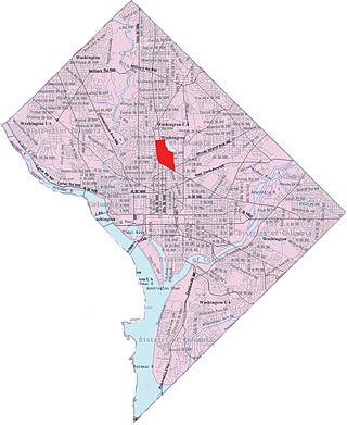
The neighborhood is generally agreed to be bounded by Chevy Chase (Washington, D.C.) to the Northwest, Rock Creek Park to the East, Forest Hills (Washington, D.C.) to the South, and barely touches Wakefield, Washington, D.C. at the very bottom. It starts at Nebraska Avenue and ends at Rock Creek Park at Utah Avenue. Opinions differ on the southern boundary, where Woodmont meets Forest Hills, but many residents consider it to be Broad Branch Road between 32nd and 27th streets. The major roads include Military Road and Nebraska Avenue, though some do not consider the border to be part of the neighborhood. The area is served by the M4, E2, and E4 Metrobus lines, and D31, D32, D34, and W45 during school hours. Woodmont is within walking distance of three Red Line stations: Van Ness-UDC, Tenleytown-AU, and Friendship Heights. The public schools that serve Woodmont are Lafayette Elementary, Ben W. Murch Elementary, Alice Deal Middle School, and Woodrow Wilson High School (Washington, D.C.). Woodmont also contains Francis G. Newlands Park, better known as Little Forest.
The founding of this neighborhood is mostly the same as Chevy Chase (Washington, D.C.) until they seceded to form their own community. This area of what used to be Chevy Chase felt separate enough to create its own neighborhood. There are many socioeconomic differences between the residents of Woodmont and Chevy Chase. This is why in 2016, residents of the area decided to create Woodmont, a neighborhood where the people feel connected.
Only one school is actually located in Woodmont D.C., which is St. John's College High School, a private Catholic High School, though many residents attend Lafayette Elementary, Ben W. Murch Elementary, Alice Deal Middle School, and Jackson-Reed High School, as well as other various private and charter schools.
| | This District of Columbia related article is a stub. You can help Wikipedia by expanding it. |

Chevy Chase Section Three is a village in Montgomery County, Maryland, United States. It was organized as a special tax district in 1916 and incorporated as a village in 1982. The population was 802 at the 2020 census.

Chevy Chase is the name of both a town and an unincorporated census-designated place that straddle the northwest border of Washington, D.C., and Montgomery County, Maryland, United States. Several settlements in the same area of Montgomery County and one neighborhood of Washington include Chevy Chase in their names. These villages, the town, and the CDP share a common history and together form a larger community colloquially referred to as Chevy Chase.

Tenleytown is a historic neighborhood in Northwest, Washington, D.C.

Northwest is the northwestern quadrant of Washington, D.C., the capital of the United States, and is located north of the National Mall and west of North Capitol Street. It is the largest of the four quadrants of the city, and it includes the central business district, the Federal Triangle, and the museums along the northern side of the National Mall, as well as many of the District's historic neighborhoods.

Friendship Heights is an urban commercial and residential neighborhood in northwest Washington, D.C., and southern Montgomery County, Maryland. Though its borders are not clearly defined, Friendship Heights consists roughly of the neighborhoods and commercial areas around Wisconsin Avenue north of Fessenden Street NW and Tenleytown to Somerset Terrace and Willard Avenue in Maryland, and from River Road in the west to Reno Road and 41st Street in the east. Within Maryland west of Wisconsin Avenue is the Village of Friendship Heights, technically a special taxation district.

Deanwood is a neighborhood in Northeast Washington, D.C., bounded by Eastern Avenue to the northeast, Kenilworth Avenue to the northwest, Division Avenue to the southeast, and Nannie Helen Burroughs Avenue to the south.

Forest Hills is a residential neighborhood in the northwest quadrant of Washington, D.C., United States, bounded by Connecticut Avenue NW to the west, Rock Creek Park to the east, Chevy Chase to the north, and Tilden Street NW to the south. The neighborhood is frequently referred to as Van Ness because it is served by the Van Ness–UDC station on the Washington Metro's Red Line and is near the Van Ness campus of the University of the District of Columbia (UDC).

Chevy Chase is a neighborhood in northwest Washington, D.C. It borders Chevy Chase, Maryland.

Glover Park is a neighborhood in northwest Washington, D.C., about a half mile north of Georgetown and just west of the United States Naval Observatory and Number One Observatory Circle. Every morning and evening, Glover Park residents can hear the Naval Observatory play the sounding of colors synchronized to the nation's Master Clock. It is named after Charles Carroll Glover.

Connecticut Avenue is a major thoroughfare in the Northwest quadrant of Washington, D.C., and suburban Montgomery County, Maryland. It is one of the diagonal avenues radiating from the White House, and the segment south of Florida Avenue was one of the original streets in Pierre (Peter) Charles L'Enfant's plan for Washington. A five-mile segment north of Rock Creek was built in the 1890s by a real-estate developer.
Pleasant Plains is a neighborhood in central Washington, D.C. largely occupied by Howard University. For this reason it is also sometimes referred to as Howard Town or, less frequently, Howard Village.

The Rock Creek Railway, which operated independently from 1890 to 1895, was one of the first electric streetcar companies in Washington, D.C., and the first to extend into Maryland.

Woodley Park is a neighborhood in Northwest, Washington, DC. It is bounded on the north by Woodley Road and Klingle Road, on the east by the National Zoo and Rock Creek Park, on the south by Calvert Street, on the southwest by Cleveland Avenue, and on the west by 34th Street.

Wakefield is a neighborhood in the Northwest quadrant of Washington, D.C., bounded by Albemarle Street NW to the south, Nebraska Avenue NW to the west, and Connecticut Avenue to the east. It is served by the Van Ness-UDC and Tenleytown-AU station on the Washington Metro's Red Line.

Hawthorne is a neighborhood of 308 single family homes in the Northwest quadrant of Washington, D.C. According to neighborhood lore, the subdivision was named for the hawthorn trees once abundant in the area. The neighborhood borders Montgomery County, Maryland, and is bounded by Pinehurst Tributary to the south, Western Avenue to the northwest, and Rock Creek Park to the east.

Barnaby Woods is a neighborhood in the Northwest quadrant of Washington, D.C., wedged between Rock Creek Park and Montgomery County, Maryland. It is bounded on the north by Aberfoyle Place, on the west by Western Avenue, on the south by Tennyson Street, and on the east by Oregon Avenue. Barnaby Woods is entirely residential, with no commercial zoning whatsoever, and the housing consists primarily of 1930s colonial homes on large parcels of land although on Unicorn Lane NW there are only townhouses.

Western Avenue is one of three boundary streets between Washington, D.C., and the state of Maryland. It follows a southwest-to-northeast line, beginning at Westmoreland Circle in the south and ending at Oregon Avenue NW in the north. It is roughly 3.5 miles (5.6 km) in length. First proposed in 1893, it was constructed somewhat fitfully from about 1900 to 1931.

The Connecticut Avenue Line, designated Route L2, is a daily bus route in Northwest Washington, D.C., United States. The L2 operates seven days a week.

Reno was a town and then neighborhood in Washington, D.C. that existed from the 1860s into the mid-twentieth century on the ground that is now Fort Reno Park in the Tenleytown neighborhood. The town's residents were largely African American, which eventually led to its clearance for Fort Reno Park and Alice Deal Middle School. Its original developers referred to it as Reno City, however this name faded from use before the 1920s.
Military Road is a major east–west collector road and limited-access road in the northwestern quadrant of Washington, D.C., United States.