
The 856 Damghan earthquake or the 856 Qumis earthquake occurred on 22 December 856. The earthquake had an estimated magnitude of 7.9, and a maximum intensity of X (Extreme) on the Mercalli intensity scale. The meizoseismal area extended for about 350 kilometres (220 mi) along the southern edge of the eastern Alborz mountains of present-day Iran including parts of Tabaristan and Gorgan. The earthquake's epicenter is estimated to be close to the city of Damghan, which was then the capital of the Persian province of Qumis. It caused approximately 200,000 deaths and is listed by the USGS as the sixth deadliest earthquake in recorded history. This death toll has been debated.
The 1932 Ierissos earthquake occurred at 19:20 on 26 September. It caused severe damage in Ierissos, Greece and the surrounding part of the Chalkidiki peninsula, with 161–491 casualties reported.
The 1932 Changma earthquake occurred at 10:04:27 local time on 25 December. With an estimated magnitude of 7.6 on the surface wave magnitude scale, and a maximum felt intensity of X (Extreme) on the Mercalli intensity scale, the quake destroyed 1,167 houses and caused 275 to 70,000 deaths and 320 injuries.

The 1944 Tōnankai earthquake occurred at 13:35 local time on 7 December. It had an estimated magnitude of 8.1 on the moment magnitude scale and a maximum felt intensity of greater than 5 Shindo. It triggered a large tsunami that caused serious damage along the coast of Wakayama Prefecture and the Tōkai region. Together, the earthquake and tsunami caused 3,358 casualties.
The 1892 Laguna Salada earthquake occurred at . It had an estimated moment magnitude of 7.1–7.2 and a maximum perceived intensity of VIII (Severe). The shock was centered near the Mexico–United States border and takes its name from a large dry lake bed in Baja California, Mexico. There were no reported casualties, but the event affected the then largely-uninhabited areas of northern Mexico and Southern California.
An earthquake occurred in the northern Aegean Sea between Greece and Turkey on May 24, 2014. It had a moment magnitude of 6.9 and a maximum Mercalli intensity of VIII (Severe). Serious damage was reported on the Turkish island of Imbros and the cities of Edirne and Çanakkale, as well as on the Greek island of Lemnos. The earthquake was felt in Bulgaria and southern Romania. Several aftershocks followed the main shock, the strongest measuring 5.3 ML. This aftershock struck the Gulf of Saros at 12:31 local time.
The 2006 Mozambique earthquake occurred at 22:19 UTC on 22 February. It had a magnitude of 7.0 on the moment magnitude scale and caused 4 deaths and 36 injuries. The epicenter was near Machaze in Manica Province of southern Mozambique, just north of the Save River. It was the largest historical earthquake in Mozambique and the first earthquake in southern Africa to have an identified surface rupture.
The 1930 Bago (Pegu) earthquake, also known as the Swa earthquake struck Myanmar on 5 May. The moment magnitude (Mw ) 7.4 earthquake had a focal depth of 35 km (22 mi) and maximum Rossi–Forel intensity of IX. The earthquake was the result of rupture along a 131 km (81 mi) segment of the Sagaing Fault—a major strike-slip fault that runs through the country. Extensive damage was reported in the southern part of the country, particularly in Bago and Yangon, where buildings collapsed and fires erupted. At least 550, and possibly up to 7,000 people were killed. A moderate tsunami was generated along the Burmese coast which caused minor damage to ships and a port. It was felt for over 570,000 km2 (220,000 sq mi) and as far as Shan State and Thailand. The mainshock was followed by many aftershocks; several were damaging; additional earthquakes occurred in July and December, killing dozens. The December earthquake was similarly sized which also occurred along the Sagaing Fault.
The 1973 Luhuo earthquake struck near the town of Zhaggo in Garzê Tibetan Autonomous Prefecture of Sichuan Province, China on February 6, 1973, with a magnitude of 7.6 . The earthquake had a maximum intensity of X (Extreme) on the Modified Mercalli intensity scale. It resulted in between 2,175 and 2,204 deaths and a further 2,743 injuries. Serious and widespread destruction occurred in Luhuo County.
A major earthquake occurred during the rule of the Qing dynasty in Shandong Province on July 25, 1668. It had an estimated magnitude of 8.5, making it the largest historical earthquake in East China, and one of the largest to occur on land. An estimated 43,000 to 50,000 people were killed, and its effects were widely felt. Its epicenter may have been located between Ju and Tancheng counties, northeast of the prefecture-level city of Linyi in southern Shandong.
The 1739 Yinchuan–Pingluo earthquake rocked the northern Ningxia Hui Autonomous Region on January 3 with an epicenter in the prefecture-level city Shizuishan. The estimated magnitude 7.1–7.6 earthquake had a maximum intensity of XI on the Mercalli intensity scale, and killed about 50,000 residents and officials. It was widely felt; perceived in Shanxi, Shaanxi and Hebei provinces. Aftershocks persisted for more than two years with the largest being a 5.5 on February 13 that same year.
The 1889 Chilik earthquake occurred on July 11 on the Gregorian calendar, or June 30 on the Julian calendar at 15:14 local time in the Tien Shan mountains. The earthquake measured an estimated Mw 7.9–8.0 on the moment magnitude scale and was assigned a maximum intensity of X (Devastating) on the MSK 64 and Rossi-Forel scales. Over 92 people across Kazakhstan, Kyrgyzstan and China were killed.

The 1695 Linfen earthquake struck Shanxi Province in North China, Qing dynasty on May 18. Occurring at a shallow depth within the continental crust, the surface-wave magnitude 7.8 earthquake had a maximum intensity of XI on the China seismic intensity scale and Mercalli intensity scale. This devastating earthquake affected over 120 counties across eight provinces of modern-day China. An estimated 52,600 people died in the earthquake, although the death toll may have been 176,365.
The 1850 Xichang earthquake rocked Sichuan Province of Qing China on September 12. The earthquake which caused major damage in Xichang county had an estimated moment magnitude of 7.6–7.9 Mw and a surface wave magnitude of 7.5–7.7 Ms . An estimated 20,650 people died.
The 1997 Bojnurd earthquake occurred on 4 February at 14:07 IRST in Iran. The epicenter of the 6.5 earthquake was in the Kopet Dag mountains of North Khorasan, near the Iran–Turkmenistan border, about 579 km (360 mi) northeast of Tehran. The earthquake is characterized by shallow strike-slip faulting in a zone of active faults. Seismic activity is present as the Kopet Dag is actively accommodating tectonics through faulting. The earthquake left 88 dead, 1,948 injured, and affected 173 villages, including four which were destroyed. Damage also occurred in Shirvan and Bojnord counties. The total cost of damage was estimated to be over US$ 30 million.
The 2019 East Azerbaijan earthquake occurred at 03:17 local-time on November 8, 2019. This earthquake had a moment magnitude of 5.9 and had a shallow depth of 20 km.
The region of Ningxia was struck by a major earthquake on the morning of 14 October 1709. It had an estimated magnitude of 7.5 and a maximum felt intensity of X (extreme) on the Modified Mercalli intensity scale. The city of Zhongwei was badly damaged, including a section of the Great Wall. A total of 2,032 people were killed.

The 1641 Tabriz earthquake occurred on the night of February 5 in present-day East Azerbaijan province, Iran. The earthquake had an estimated surface-wave magnitude of 6.8 and an epicenter between Lake Urmia and the city of Tabriz. It was one of the most destructive earthquakes in the region, resulting in the loss of up to 30,000 lives.
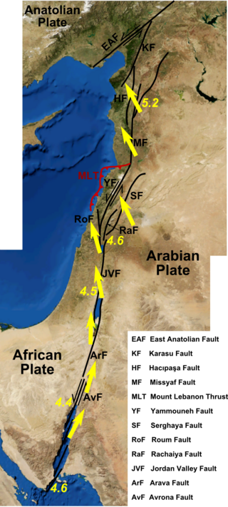
An earthquake struck the Jordan Rift Valley on December 5, 1033 and caused extreme devastation in the Levant region. It was part of a sequence of four strong earthquakes in the region between 1033 AD and 1035 AD. Scholars have estimated the moment magnitude to be greater than 7.0 Mw and evaluated the Modified Mercalli intensity to X (Extreme). It triggered a tsunami along the Mediterranean coast, causing damage and fatalities. At least 70,000 people were killed in the disaster.
The 1977 Naghan earthquake struck Chaharmahal and Bakhtiari province in Iran on April 6 at 13:36 UTC. The earthquake measuring 6.0 Mw occurred at a depth of 15 km (9.3 mi) and had a maximum Modified Mercalli intensity of VIII (Severe). More than 2,100 homes were destroyed and at least 348 people were killed.

