The 2005 Nias–Simeulue earthquake occurred on 28 March off the west coast of northern Sumatra, Indonesia. At least 915 people were killed, mostly on the island of Nias. The event caused panic in the region, which had already been devastated by the massive tsunami triggered by the 2004 Indian Ocean earthquake, but this earthquake generated a relatively small tsunami that caused limited damage. It was the third most powerful earthquake since 1965 in Indonesia.
The 1957 Andreanof Islands earthquake occurred at 04:22 local time on March 9 with a moment magnitude estimated between 8.6 and 9.1 and a maximum Modified Mercalli intensity of VIII (Severe). It occurred south of the Andreanof Islands group, which is part of the Aleutian Islands arc. The event occurred along the Aleutian Trench, the convergent plate boundary that separates the Pacific Plate and the North American plates near Alaska. A basin-wide tsunami followed, with effects felt in Alaska and Hawaii, and strong waves recorded across the Pacific rim. Total losses were around $5 million.
The 2006 Tonga earthquake occurred on 4 May at with a moment magnitude of 8.0 and a maximum Mercalli intensity of VII. One injury occurred and a non-destructive tsunami was observed.

An earthquake occurred on July 17, 2006 at along a subduction zone off the coast of west and central Java, a large and densely populated island in the Indonesian archipelago. The shock had a moment magnitude of 7.7 and a maximum perceived intensity of IV (Light) in Jakarta, the capital and largest city of Indonesia. There were no direct effects of the earthquake's shaking due to its low intensity, and the large loss of life from the event was due to the resulting tsunami, which inundated a 300 km (190 mi) portion of the Java coast that had been unaffected by the earlier 2004 Indian Ocean earthquake and tsunami that was off the coast of Sumatra. The July 2006 earthquake was also centered in the Indian Ocean, 180 kilometers (110 mi) from the coast of Java, and had a duration of more than three minutes.
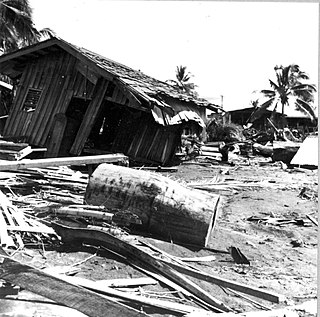
The 1976 Moro Gulf earthquake and tsunami occurred on near the islands of Mindanao and Sulu, in the Philippines. It meaured 8.0 on the moment magnitude scale occurring at a depth of 20 km (12 mi). The earthquake was accompanied by a destructive tsunami that resulted in a majority of the estimated 5,000 to 8,000 fatalities. It was the deadliest and strongest earthquake in the Philippines in 58 years since the 1918 Celebes Sea earthquake.
The 1984 Morgan Hill earthquake occurred on April 24 at in the Santa Clara Valley of Northern California. The shock had a moment magnitude of 6.2 and a maximum Mercalli intensity of VIII (Severe). The epicenter was located near Mount Hamilton in the Diablo Range of the California Coast Ranges. Nearby communities sustained serious damage with financial losses of at least US$7.5 million.

The Galilee earthquake of 1837, often called the Safed earthquake, shook the Galilee on January 1 and is one of a number of moderate to large events that have occurred along the Dead Sea Transform (DST) fault system that marks the boundary of two tectonic plates; the African Plate on the west and the Arabian Plate on the east. Intensity assessments for the event were VIII (Damaging) on the Medvedev–Sponheuer–Karnik scale and VIII on the European Macroseismic Scale.
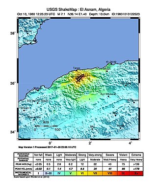
The 1980 El Asnam earthquake occurred on October 10 at with a moment magnitude of 7.1 and a maximum Mercalli intensity of X (Extreme). The shock occurred in the Algerian town of El Asnam. The shocks were felt over 550 km (340 mi) away, with the initial earthquake lasting 35 seconds. It was the largest earthquake in Algeria, and was followed three hours later by a magnitude 6.2 aftershock. The earthquake created about 42 km (26 mi) of surface rupture and had a vertical slip of up to 4.2 m (14 ft). No foreshocks were recorded. The earthquake was found to have occurred very close to the epicenter of the 1954 Chlef earthquake using joint epicenter determination techniques. It occurred at a previously unknown reverse fault.
The 1982 North Yemen earthquake hit near the city of Dhamar, North Yemen on December 13. Measuring 6.2 on the moment magnitude scale, with a maximum perceived intensity of VIII (Severe) on the Mercalli intensity scale, as many as 2,800 people were killed and another 1,500 injured. The shock occurred within several hundred kilometers of a plate boundary in a geologically complex region that includes active volcanoes and seafloor spreading ridges. Yemen has a history of destructive earthquakes, though this was the first instrumentally recorded event to be detected on global seismograph networks.
The 1995 Colima–Jalisco earthquake occurred on October 9 at 15:35 UTC with a moment magnitude of 8.0 and a maximum Mercalli intensity of VIII (Severe). The shock occurred off the coast of Jalisco, Mexico, where a tsunami was triggered that affected a 200 km (120 mi) stretch of the coast. The earthquake could be felt in Mexico City and in high-rise buildings in Dallas and Houston. In Mexico, the Cihuatlan-Manzanillo was the most severely affected area. At least 49 people died and 100 were injured.
The 1935 Erdek–Marmara Islands earthquake occurred at 4 January on the islands of Marmara and Avşa off Erdek in the Sea of Marmara, Turkey. It had a moment magnitude of 6.4 and a maximum felt intensity of VIII (Severe) on the Mercalli intensity scale, causing 5 deaths and 30 injuries.
The 1994 Kuril Islands earthquake – also known as the Hokkaido Toho-oki earthquake – occurred on . The magnitude of this earthquake was put at 8.3, or 8.1. The epicenter was located at about 70 km east of Shikotan Island. The shaking and tsunami caused road and building damage. At least 10 people were reported dead.
The 1959 Kamchatka earthquake occurred on May 4 at with a moment magnitude of 8.0–8.3, and a surface wave magnitude of 8.25. The epicenter was near the Kamchatka Peninsula, Russian SFSR, USSR. Building damage was reported in Petropavlovsk-Kamchatsky. The maximum intensity was VIII (Damaging) on the Medvedev–Sponheuer–Karnik scale. The intensity in Petropavlovsk-Kamchatsky was about VIII MSK.
The 2012 Haida Gwaii earthquake occurred just after . The shock had a moment magnitude of 7.8 and a maximum Mercalli Intensity of V (Moderate). The earthquake's epicentre was on Moresby Island of the Haida Gwaii archipelago. This was the second largest Canadian earthquake ever recorded by a seismometer, after the 1949 Queen Charlotte Islands earthquake, about 135 kilometres (84 mi) away. One person died due to a car crash related to the tsunami in Oahu, Hawaii.
The 2004 Les Saintes earthquake occurred at on November 21, 2004 with a moment magnitude of 6.3 and maximum European macroseismic intensity of VIII. The shock was named for Îles des Saintes "Island of the Saints", a group of small islands to the south of Guadeloupe, which is an overseas department of France. Although it occurred near the Lesser Antilles subduction zone, this was an intraplate, normal fault event. It resulted in one death, 13 injuries, and 40 people being made homeless, but the overall damage was considered moderate. A small, nondestructive tsunami was reported, but run-up and inundation distances were difficult to measure due to a storm that occurred on the day of the event. Unusual effects at a volcanic lake on Dominica were also documented, and an aftershock caused additional damage three months later.
The 1994 Mascara earthquake occurred on August 18 at 02:13 local time with an epicenter in a rural part of Algeria. The earthquake measured 5.8 on the moment magnitude scale (Mw ) and had a depth of 10 km (6.2 mi). It caused the deaths of 171 people, left up to 12,500 homeless, and destroyed thousands of homes in Mascara Province. Many homes were damaged or destroyed due to poor building quality which collapsed on the inhabitants and resulted in a majority of the casualties. The national government launched a rapid response effort in its aftermath.
On April 13, 1923 at 15:31 UTC, an earthquake occurred off the northern coast of the Kamchatka Peninsula in the USSR, present-day Russia. The earthquake had a surface-wave magnitude (Ms ) of 6.8–7.3 and an estimated moment magnitude (Mw ) of 7.0–8.2. This event came just two months after a slightly larger earthquake with an epicenter struck south of the April event. Both earthquakes were tsunamigenic although the latter generated wave heights far exceeding that of the one in February. After two foreshocks of "moderate force", the main event caused considerable damage. Most of the 36 casualties were the result of the tsunami inundation rather than the earthquake.
The 1941 Sa'dah earthquake or the Jabal Razih earthquake occurred on January 11 in Razih District of the Mutawakkilite Kingdom of Yemen. The earthquake had a surface-wave magnitude of 5.8–6.5 and a shallow focal depth. Despite the moderate size of this earthquake, an estimated 1,200 people perished and at least 200 injured. With a maximum MSK-64 intensity assigned at VIII, it destroyed many villages and collapsed homes in the region of North Yemen.

On 5 September 1996 at 22:44 local time, southern Dalmatia, Croatia, was hit by a strong earthquake of moment magnitude 6.0. The epicentre was near the coastline of the Adriatic Sea, close to the village of Slano, roughly 15 kilometres (9.3 mi) northwest of Dubrovnik. The worst damage was of intensity VIII on the Medvedev–Sponheuer–Karnik scale, occurring in the epicentral area, but also another 25 km (16 mi) northwest, at the isthmus of the Pelješac peninsula, around the old town of Ston.

The 1940 Shakotan earthquake occurred on August 2 at 00:08:22 JST with a moment magnitude (Mw ) of 7.5 and maximum JMA seismic intensity of Shindo 4. The shock had an epicenter off the coast of Hokkaido, Japan. Damage from the shock was comparatively light, but the accomanying tsunami was destructive. The tsunami caused 10 deaths and 24 injuries on Hokkaido, and destroyed homes and boats across the Sea of Japan. The highest tsunami waves were recorded at the coast of Russia while along the coast of Hokkaido, waves were about 2 m.
