
The 1953 Yenice–Gönen earthquake occurred at 21:06 local time (19:06 UTC on 18 March in the province of Çanakkale and Balıkesir in the Marmara Region at western Turkey. It had a surface wave magnitude of 7.5 and a maximum felt intensity of IX on the Mercalli intensity scale. It caused widespread damage, killing 1,070 and causing damage that was estimated at US$3,570,000 repair value.
The 1991 Uttarkashi earthquake occurred at 02:53:16 Indian Standard Time (UTC+05:30) on 20 October with a moment magnitude of 6.8 and a maximum Mercalli intensity of IX (Violent). This thrust event was instrumentally recorded and occurred along the Main Central Thrust in the Uttarkashi and Gharwal regions of the Indian state of Uttarakhand. High intensity shaking resulted in the deaths of at least 768 people and the destruction of thousands of homes.

The 1927 Gulang earthquake occurred at 6:32 a.m. on 22 May. This 7.6 magnitude event had an epicenter near Gulang, Gansu in the Republic of China. There were 40,912 deaths. It was felt up to 700 km (435 mi) away.
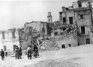
The 1930 Irpinia earthquake occurred at 00:08 UTC on 23 July, chiefly in an area known as Irpinia. It had a surface wave magnitude of 6.6 and a maximum intensity of X . The event caused 1,404 deaths and 4,624–7,000 injuries. The epicenter was near the boundaries between the regions of Basilicata, Apulia, and Campania.
A Mw 6.8 earthquake occurred on 24 March 2011 in Shan State, Myanmar. It had an epicenter northwest of the border between Myanmar, Thailand and Laos. The earthquake killed between 75 and 151 people; including one fatality in Thailand. Hundreds of buildings were damaged in Myanmar and Thailand. An additional 212 people were injured.

The Sagaing Fault is a major fault in Myanmar, a mainly continental right-lateral transform fault between the Indian Plate and Sunda Plate. It links the divergent boundary in the Andaman Sea with the zone of active continental collision along the Himalayan front. It passes through populated cities of Mandalay, Yamethin, Pyinmana, the capital Naypyidaw, Toungoo and Pegu before dropping off into the Gulf of Martaban, running for a total length of over 1200 kilometers.
The 1762 Arakan earthquake occurred at about 17:00 local time on 2 April, with an epicentre somewhere on the coast from Chittagong to Arakan in modern Myanmar. It had an estimated moment magnitude between 8.5 and 8.8 and a maximum estimated intensity of XI (Extreme). It triggered a local tsunami in the Bay of Bengal and caused at least 200 deaths. The earthquake was associated with major areas of both uplift and subsidence. It is also associated with a change in course of the Brahmaputra River to from east of Dhaka to 150 kilometres (93 mi) to the west via the Jamuna River.
The 1931 Myitkyina earthquake, or also known as the 1931 Kamaing earthquake, occurred on January 28 at 02:35 local time. It was located in northern Burma, then part of British India. The magnitude of this earthquake was put at 7.6. According to some sources the depth was 35 km, and according to a study of Phyo M. M. the depth was 5 to 30 km.

The 2012 Shwebo earthquake occurred at 07:42 local time on 11 November in Myanmar. It had a magnitude of 6.8 on the moment magnitude scale and a maximum perceived intensity of VIII (Severe) on the Mercalli intensity scale. The epicenter was near the town of Male, 52 km NNE of the city of Shwebo, 64 km west of Mogok and 120 km north of Mandalay. Significant damage and possible casualties have been reported from near the epicenter, with up to 26 people dead and many more injured. Part of a bridge under construction fell into the Irrawaddy River near Shwebo and a gold mine collapsed at Sintku. An aftershock with a magnitude of 5.8 followed at 17:24 local time.
The 1956 Sagaing earthquake occurred on July 16, 1956, at 15:07 UTC. The earthquake was located near Sagaing, Burma. This earthquake had a magnitude of 7.1.
The 1946 Sagaing earthquakes struck central Burma at 15:17 local time on 12 September. The first earthquake measured a magnitude of 7.3 Mw and was followed by a 7.7 Mw earthquake. Both events remain some of the largest in the country since the 1762 Arakan earthquake.
The 1912 Maymyo earthquake or Burma earthquake struck Burma on the morning of May 23, with an epicentre near Taunggyi and Pyin Oo Lwin in Shan State. The earthquake was initially calculated at 8.0 on the surface wave magnitude scale (Ms ) by Beno Gutenberg and Charles Francis Richter, and described by them as being one of the most remarkable seismic events in the early 1900s. Recent re-evaluation of the earthquake, however, have revised the magnitude to 7.6–7.9. It was preceded by two foreshocks on May 18 and 21 with respective intensities V and VII on the Rossi–Forel scale, while the mainshock was assigned IX. Shaking was felt throughout most of Burma, parts of Siam and Yunnan; an area covering approximately 375,000 square miles. It was one of the largest earthquakes in the country.
The 1930 Bago (Pegu) earthquake, also known as the Swa earthquake struck Myanmar on 5 May. The moment magnitude (Mw ) 7.4 earthquake had a focal depth of 35 km (22 mi) and maximum Rossi–Forel intensity of IX. The earthquake was the result of rupture along a 131 km (81 mi) segment of the Sagaing Fault—a major strike-slip fault that runs through the country. Extensive damage was reported in the southern part of the country, particularly in Bago and Yangon, where buildings collapsed and fires erupted. At least 550, and possibly up to 7,000 people were killed. A moderate tsunami was generated along the Burmese coast which caused minor damage to ships and a port. It was felt for over 570,000 km2 (220,000 sq mi) and as far as Shan State and Thailand. The mainshock was followed by many aftershocks; several were damaging; additional earthquakes occurred in July and December, killing dozens. The December earthquake was similarly-sized which also occurred along the Sagaing Fault.

The 1839 Ava earthquake, also known as the Amarapura earthquake or Inwa earthquake, was a disastrous seismic event that struck central Burma on the morning of March 23. This earthquake with a moment magnitude as high as 8.3, was one of the biggest in the country since 1762. Shaking reached XI (Extreme) on the Modified Mercalli intensity scale, and was felt in Rangoon and Bhamo.
The Haiyuan Fault is a major active intracontinental strike-slip (sinistral) fault in Central Asia.
The 1988 Lancang–Gengma earthquakes, also known as the 11.6 earthquakes by the Chinese media were a pair of devastating seismic events that struck Lancang and Gengma counties, Yunnan, near the border with Shan State, Burma. The earthquake measured moment magnitude (Mw ) 7.0 and was followed 13 minutes later by a 6.9 Mw shock. These earthquakes were assigned a maximum China seismic intensity of IX and X, respectively. Between 748 and 939 people were killed; more than 7,700 were injured. Both earthquakes resulted in US$270 million in damage and economic losses. Moderately large aftershocks continued to rock the region, causing additional casualties and damage.
The 1995 Menglian earthquake or 1995 Myanmar–China earthquake occurred on 12 July at 05:46:43 local time in the Myanmar–China border region. The earthquake had an epicenter on the Myanmar side of the border, located in the mountainous region of Shan State. It registered 7.3 on the Chinese surface wave magnitude scale (Ms ) and 6.8 on the moment magnitude scale (Mw ). With a maximum Mercalli intensity assigned at VIII, the quake killed eleven people and left another 136 injured. Over 100,000 homes in both countries were destroyed and 42,000 seriously damaged. Some damage to structures were also reported in Chiang Mai and Chiang Rai, Thailand. The low death toll from this earthquake was attributed to an early warning issued prior to it happening. Precursor events including foreshocks and some seismic anomalies led to an evacuation of the area before the mainshock struck. It is thought to be one of the few successfully predicted earthquakes in history.
The 1997 Bojnurd earthquake occurred on 4 February at 14:07 IRST in Iran. The epicenter of the 6.5 earthquake was in the Kopet Dag mountains of North Khorasan, near the Iran–Turkmenistan border, about 579 km (360 mi) northeast of Tehran. The earthquake is characterized by shallow strike-slip faulting in a zone of active faults. Seismic activity is present as the Kopet Dag is actively accommodating tectonics through faulting. The earthquake left 88 dead, 1,948 injured, and affected 173 villages, including four which were destroyed. Damage also occurred in Shirvan and Bojnord counties. The total cost of damage was estimated to be over US$ 30 million.
The 1858 Prome earthquake occurred on August 24 at 15:38 local time in British Burma. The earthquake occurred with a magnitude of 7.6–8.3 on the moment magnitude scale. It had an epicenter in near the city of Pyay (Prome), Bago. The shock was felt with a maximum Modified Mercalli intensity of XI (Extreme) for about one minute. Severe damage was reported in Bago, and off the coast of Rakhine, an island sunk.
