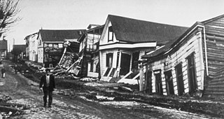
The 1960 Valdivia earthquake and tsunami or the Great Chilean earthquake on 22 May 1960 was the most powerful earthquake ever recorded. Most studies have placed it at 9.4–9.6 on the moment magnitude scale, while some studies have placed the magnitude lower than 9.4. It occurred in the afternoon, and lasted 10 minutes. The resulting tsunamis affected southern Chile, Hawaii, Japan, the Philippines, eastern New Zealand, southeast Australia, and the Aleutian Islands.
The 1861 Mendoza earthquake occurred in the province of Mendoza, Argentina on 20 March at 11:30 PM. It had an estimated magnitude of 7.2 on the scale and an intensity of IX–X on the Mercalli scale. Its hypocenter was located at an estimated depth of 30 kilometres (19 mi).

The 1977 San Juan earthquake, also known as Caucete earthquake, took place in the province of San Juan, Argentina, on 23 November at 06:26:26 AM. It measured 7.4 on the surface wave magnitude scale, and had a maximum perceived intensity of X (Extreme) on the Mercalli intensity scale.
The 1894 San Juan earthquake took place in the province of San Juan, Argentina, on 27 October 1894, at about 07:30 PM. It was the most powerful earthquake recorded in Argentina, with magnitude 7.5 on the surface wave magnitude scale. Its epicenter was located to the northwest of San Juan, approximately at 29°48′S69°00′W, and at a depth of 30 km.
The 1952 San Juan earthquake took place on 11 June at 00:31:43 UTC in the province of San Juan, Argentina. It measured 6.8 on the moment magnitude scale with a depth of 30 kilometers (19 mi). The earthquake was felt in San Juan with a maximum of VIII (Severe) on the Mercalli intensity scale. It caused damage in some locations in the south and west of the province, and a small number of casualties.
The Pichilemu Fault, also referred to as the Pichilemu-Vichuquén Fault, is a Chilean geological fault, located in Libertador General Bernardo O'Higgins Region, some kilometers away from Pichilemu, at a depth of 15 kilometres (9.3 mi). The fault is 40 kilometres (25 mi) long and 20 kilometres (12 mi) wide.

The 2011 Lorca earthquake was a moderate 5.1 earthquake that occurred 6:47 p.m. CEST on 11 May 2011, near the town of Lorca, causing significant localized damage in the Region of Murcia, Spain, and panic among locals, and displacing many from their homes. The quake was preceded by a magnitude 4.4 foreshock at 17:05, that inflicted substantial damage to many older structures in the area, including the historical Espolón Tower of Lorca Castle, the Hermitage of San Clemente and the Convent of Virgen de Las Huertas. Three people were killed by a falling cornice. A total of nine deaths have been confirmed, while dozens are reported injured. The earthquake was the worst to hit the region since a 5.0 Mw tremor struck west of Albolote, Granada in 1956.

The 2010 Pichilemu earthquakes, also known as the Libertador O'Higgins earthquakes, were a pair of intraplate earthquakes measuring 6.9 and 7.0 that struck Chile's O'Higgins Region on 11 March 2010 about 16 minutes apart. The earthquakes were centred 15 kilometres (9.3 mi) northwest of the city of Pichilemu.

The El Tigre Fault is a 120 km long, roughly north-south trending, major strike-slip fault located in the Western Precordillera in Argentina. The Precordillera lies just to the east of the Andes mountain range in South America. The northern boundary of the fault is the Jáchal River and its southern boundary is the San Juan River. The fault is divided into three sections based on fault trace geometry, Northern extending between 41–46 km in length, Central extending between 48–53 km in length, and Southern extending 26 km in length. The fault displays a right-lateral (horizontal) motion and has formed in response to stresses from the Nazca Plate subducting under the South American Plate. It is a major fault with crustal significance. The Andes Mountain belt trends with respect to the Nazca Plate/South American Plate convergence zone, and deformation is divided between the Precordilleran thrust faults and the El Tigre strike-slip motion. The El Tigre Fault is currently seismically active.
An earthquake occurred on 26 August 2012 at 22:37 local time. The earthquake located off the coast of El Salvador measured 7.3 on the moment magnitude scale and had a focal depth of 16.0 kilometres (10 mi). No deaths were reported, however more than 40 people were injured when they were caught in a tsunami generated by the earthquake. Waves from the tsunami were unusually large for an earthquake of this size. The large waves were attributed to the earthquake's unique rupture characteristic. In addition to the absence of fatalities, damage caused by the earthquake and tsunami was minimal as a result of the sparse population around the affected region and the slow rupture characteristic of the event.
The 1900 Venezuelan earthquake, occurred on October 28 at between 4:30 and 4:45 am local time. This earthquake had an epicenter off Miranda State or near the Venezuelan capital Caracas, in the Cariaco Basin. It had an estimated moment magnitude of 7.6–7.7 and a surface-wave magnitude of 7.7–8.4. It had a maximum Mercalli intensity assigned VIII–X, causing landslides and liquefaction events. Many buildings were severely damaged or collapsed during the earthquake. It is thought to be the last great earthquake of the 19th century and the largest instrumentally recorded in the republic, having been felt throughout.
Villa Ibáñez is a locality located in the south-central province of San Juan, west of the agricultural oasis of Ullúm, northwest of the city of San Juan, Argentina. It is the seat of the Ullúm Department. Today, the town is the nucleus of an important wine, fruit and olive region par excellence of the aforementioned province.
On December 5, 1456, the largest earthquake to occur on the Italian Peninsula struck the Kingdom of Naples. The earthquake had an estimated moment magnitude of Mw 7.19–7.4, and was centred near the town of Pontelandolfo in the present-day Province of Benevento, southern Italy. Earning a level of XI (Extreme) on the Modified Mercalli intensity scale, the earthquake caused widespread destruction in central and southern Italy. Estimates of the death toll range greatly with as many as 70,000 deaths reported. It was followed by two strong Mw 7.0 and 6.0 earthquakes to the north on December 30. The earthquake sequence is considered the largest in Italian history, and one of the most studied.
The 1959 Coatzacoalcos earthquake occurred at 02:25 local time on August 26 near the Mexican state of Veracruz. The earthquake measured 6.4 Mw at a depth of 21 km (13 mi), and had a maximum Modified Mercalli intensity of VIII (Severe). It had an epicenter immediately off the coast of Coatzacoalcos. The shallow back-arc thrust faulting earthquake damaged the cities of Acayucan, Coatzacoalcos, Jáltipan and Minatitlán. A total of 25 people died, including 10 from Jáltipan while a further 200 were injured. The Middle America Trench, a subduction zone that borders the southwestern coast of Mexico and Central America, accounts for much of the seismicity in Mexico. The eastern side of the country near the Gulf of Mexico rarely experiences large earthquakes although they have been recorded around the Veracruz area, where seismicity is higher compared to other parts of the gulf. Seismicity in the gulf is attributed to back-arc compression due to subduction.
The 1706 Abruzzo earthquake, also known as the Maiella earthquake, occurred on November 3 at 13:00 CEST. The earthquake with a possible epicenter in the Central Apennine Mountains (Maiella), Abruzzo had an estimated moment magnitude of 6.6–6.84 Mw . It was assigned a maximum Mercalli intensity of XI (Extreme), causing tremendous destruction in Valle Peligna. At least 2,400 people were killed.
The 1912 Acambay earthquake struck the State of Mexico on 19 November at 07:55 local time. It had a moment magnitude of 6.7–6.9 Mw and an epicenter near the town of Acambay, 80 km (50 mi) northwest of Mexico City. Up to 161 people died and there was severe destruction. It is regarded as one of the most important earthquakes in Mexico's seismological history, having been widely studied.
The 1910 Costa Rica earthquakes were a series of destructive seismic events that affected Cartago, Costa Rica from 13 April to 4 May. The sequence began with a Ms 5.8 earthquake. The largest and most destructive in the sequence occurred on 4 May, measuring Ms 6.4. A total of 2,450 people were killed and the city of Cartago was severely affected.

The 1917 San Salvador earthquake occurred on June 7 at 18:55 local time near the Salvadoran capital. The hypocenter of the Mw 6.7 was at a shallow depth of 15 km (9.3 mi), and occurred along a shallow crustal fault near San Salvador. The earthquake caused significant destruction of the city and left approximately 1,050 dead. It was followed by an eruption on San Salvador that killed another 1,100. Only behind the earthquake of 1986, it is the second deadliest in El Salvador's history.


