1996 Southern Ontario tornadoes

Last updated
1996 Southern Ontario tornadoes
TornadoArthur1996a.jpg
21/04/1996 – Arthur, Ontario – Interior of destroyed house. Tornado struck night before.
TypeTornado outbreak
DurationApril 20, 1996
Tornadoes
confirmed
3 confirmed
Max. rating1 F3 tornado
Duration of
tornado outbreak2
2–3 hours
FatalitiesNone; 9 minor injuries
DamageIn 1996 Canadian Dollars: $8 million (adjusted to 2011, CDN $11 million)
Areas affectedSouthern Ontario

1Most severe tornado damage; see Fujita scale
2Time from first tornado to last tornado

Southern Ontario's worst tornado outbreak of the decade came on Saturday, April 20, 1996. [1] Severe weather had raked parts of the U.S. Midwest the day before, where seventeen F2 or greater tornadoes touched down (ten in Illinois alone). A cold front was being dragged eastward into unusually warm and unstable air associated with a strong storm system moving through the northern tier of the U.S. Out of the two significant tornadoes that day, both rated F3, it was remarkable that there were no deaths. Nine people escaped with minor injuries.

Contents

Many homes were severely damaged in Williamsford, Arthur, and Violet Hill. Many areas that experienced the tornadoes on May 31, 1985, were hit once again, especially the Grand Valley area. The first tornado that touched down tore a 40 kilometre long path southeast of Owen Sound. A second tornado touched down farther south and took a 60 kilometre track from Arthur to just southwest of Barrie. There was a third brief touchdown near Orillia associated with the parent storm of the second tornado. [2]

Grey County tornado

Ahead of the main cold front, a separate storm formed into a supercell southwest of Williamsford in Grey County, likely triggered by the aging squall line further west. Then, at about 5:50pm, a funnel cloud touched down about 5 kilometres (3.1 miles) southwest of Williamsford. Only sporadic tree damage took place at this point. The storm was high-based, and there was a large gap between the tornado and the core of the storm which was consistent through much of the tornado's life. The wall cloud was large and showed clear signs of rotation.

As the tornado passed through town, it was large and messy, and divided into multiple vortices shortly after. The collective width of the damage path was about 400 metres (440 yards) wide and extensive debris filled the air. At Williamsford, the storm did extensive F3 damage to a strip of homes along Chatsworth Road 24, a township concession road. It then crossed Williams Lake, damaging some cottages and ripping up trees. As it crossed the small lake, it became a waterspout for a brief time, and some of the multiple vortices became visible. The tornado continued to move northeast and, as it neared Holland Centre, the winds hurled a 10,000-litre (2,600-US-gallon) gasoline tank (weighing approximately two tonnes) for more than 1.6 kilometres (1,700 yards). At this point, the tornado crossed Highway 10.

As the tornado neared the town of Walters Falls, it became more compact, but did not weaken. Damage was continuous but involved only trees. East of Walters Falls, the tornado became very strange in appearance as the funnel split into two separate vortices. A debris cloud persisted under both of these funnels as they rotated around each other. The tornado then rolled through the town of Blantyre where some homes suffered F2 damage. Shortly afterward the tornado began to weaken and finally lifted just before 6:30 pm. The parent storm then moved out over the cold waters of Georgian Bay near Meaford, where it rapidly dissipated.

Wellington and Dufferin County tornado

The storm in Wellington County initially formed northwest of London around 5:00pm and slowly moved northeast where it began to produce funnel clouds. The first touchdown was about 8 kilometres (5.0 miles) southwest of Arthur at 6:10 pm. A small funnel cloud was visible, but there was mostly just a large mass of dust at the ground. Within the next few minutes, the tornado began to take on a tube-like form. It was a multiple-vortex tornado, with as many as four distinct vortices inside the main path. The tornado's overall width was about 400 metres (440 yards). It went quickly from F1 to F2 and widened, then became an F3 as it approached town from the southwest.

Extensive damage began on the west side of Arthur shortly thereafter. As the tornado passed Highway 6, it was at its peak strength. The tornado had a separate companion for a brief time, a thin black appendage that swept around the front of the main circulation. As the main tornado crossed the highway, it destroyed a barn full of hay which tinted the tornado yellow for a brief time. The tornado's parent supercell also became more intense. A torrent of rain and hail preceded the tornado around the north side of the path.

The mesocyclone was rather large, even pulling in some of the precipitation from ahead of the storm. As the storm moved farther to the northeast, it nearly destroyed several farms before it plowed into the Luther Marsh, north of Grand Valley. East of the marsh, the storm weakened somewhat and the tornado narrowed in width. Upper-level winds were stretching out the storm causing a larger gap between the precipitation core and the tornado, thus making it even more visible to people in the storm's path. South of the tornado, it was warm, windy, and free of precipitation, with a spectacular view of the storm. The tornado damaged more homes and then crossed Highway 25, taking down several hydro transformers in one very bright power flash. The tornado now had a textbook-style appearance as a narrow wedge.

F2 damage continued on as the tornado approached the town of Shelburne in Dufferin County. Pieces of sheet metal and wood fell from the sky and littered the southern end of town after they were thrown out of the tornado. It then damaged more homes and buildings as it ripped across the southeast end of town. The tornado stayed at around F2–F3 intensity as it moved out of Shelburne into more open country. The path was now about 125 metres (137 yards) wide. It then moved toward the suburban town of Violet Hill, where several more homes sustained F2–F3 damage. Not long after, the tornado began dying out as its path narrowed to 50 metres (55 yards). Outflow from the core of the storm undercut the mesocyclone, and the tornado lifted by 7:00 pm. This storm went on to produce another brief touchdown southwest of Orillia but all severe weather died down after sunset. [3]

Seasonal rarity

Climatologists consider these Canadian tornadoes to have been quite a rare occurrence considering the early date. Never before have such intense and long tracked tornadoes occurred this early in the season in Canada.

April 1996 was unseasonably cold, so there was still snow on the ground in some areas and Lake Huron was still covered in ice. In fact, the Grey County tornado lifted a thick sheet of ice off of a pond before depositing it nearby. Light snows also fell after the event in the areas hardest hit by the tornadoes, which hampered the clean-up efforts.

Related Research Articles

<span class="mw-page-title-main">Supercell</span> Thunderstorm that is characterized by the presence of a mesocyclone

A supercell is a thunderstorm characterized by the presence of a mesocyclone: a deep, persistently rotating updraft. Due to this, these storms are sometimes referred to as rotating thunderstorms. Of the four classifications of thunderstorms, supercells are the overall least common and have the potential to be the most severe. Supercells are often isolated from other thunderstorms, and can dominate the local weather up to 32 kilometres (20 mi) away. They tend to last 2–4 hours.

<span class="mw-page-title-main">1985 United States–Canada tornado outbreak</span> 1985 record-breaking tornado outbreak in the northeast US and southern Ontario

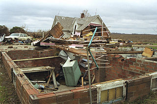
The 1985 United States–Canada tornado outbreak, referred to as the Barrie tornado outbreak in Canada, was a major tornado outbreak that occurred in Ohio, Pennsylvania, New York, and Ontario, on May 31, 1985. In all 44 tornadoes were counted including 14 in Ontario, Canada. It is the largest and most intense tornado outbreak ever to hit this region, and the worst tornado outbreak in Pennsylvania history in terms of deaths and destruction.

<span class="mw-page-title-main">Funnel cloud</span> Funnel-shaped cloud extending from a cloud base but doesnt touch the ground

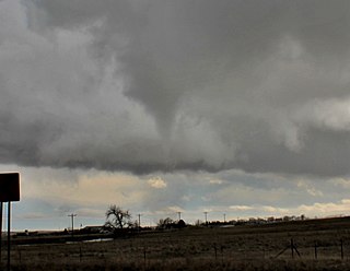
A funnel cloud is a funnel-shaped cloud of condensed water droplets, associated with a rotating column of wind and extending from the base of a cloud but not reaching the ground or a water surface. A funnel cloud is usually visible as a cone-shaped or needle like protuberance from the main cloud base. Funnel clouds form most frequently in association with supercell thunderstorms, and are often, but not always, a visual precursor to tornadoes. Funnel clouds are visual phenomena, these are not the vortex of wind itself.

<span class="mw-page-title-main">1998 Comfrey–St. Peter tornado outbreak</span>

The 1998 Comfrey–St. Peter tornado outbreak was an unseasonably-strong tornado outbreak which affected the Upper Midwest region of the United States on March 29, 1998. A strong area of low pressure combined with a warm front and favorable upper-level dynamics to produce 16 tornadoes across the region—14 in Minnesota and two in Wisconsin. Thirteen of the tornadoes in Minnesota were spawned by a single supercell thunderstorm. This supercell remained intact for approximately 150 miles (240 km) as it moved across the southern part of the state during the late-afternoon hours.

<span class="mw-page-title-main">Tornadogenesis</span> Process by which a tornado forms

Tornadogenesis is the process by which a tornado forms. There are many types of tornadoes and these vary in methods of formation. Despite ongoing scientific study and high-profile research projects such as VORTEX, tornadogenesis is a volatile process and the intricacies of many of the mechanisms of tornado formation are still poorly understood.

<span class="mw-page-title-main">Tornadoes of 2003</span>

This page documents notable tornadoes and tornado outbreaks worldwide in 2003. Strong and destructive tornadoes form most frequently in the United States, Bangladesh, and Eastern India, but they can occur almost anywhere under the right conditions. Tornadoes also develop occasionally in southern Canada during the Northern Hemisphere's summer and somewhat regularly at other times of the year across Europe, Asia, and Australia. Tornadic events are often accompanied with other forms of severe weather, including strong thunderstorms, strong winds, and hail.

<span class="mw-page-title-main">2006 Westchester County tornado</span> Tornado in New York

The 2006 Westchester County tornado was the strongest and largest tornado in Westchester County, New York since the 1904 Chappaqua tornado. It touched down there on Wednesday, July 12, 2006, and traveled 13 miles (21 km) into southwestern Connecticut during a 33-minute span through two states. The tornado touched down at 3:30 p.m. EDT (19:30 UTC) on the shore of the Hudson River before becoming a waterspout and traveling 3 mi (5 km) across the river. Coming ashore, the tornado entered Westchester County and struck the town of Sleepy Hollow at F1 intensity. After passing through the town, it intensified into an F2 tornado and grew to almost a one-quarter mile (400 m) in diameter. The tornado continued through the county, damaging numerous structures, until it crossed into Connecticut at 4:01 p.m. EDT (20:01 UTC). Not long after entering the state, it dissipated in the town of Greenwich at 4:03 p.m. EDT (20:03 UTC). When the tornado entered Westchester County, it was the eighth known tornado to either touch down or enter the county since 1950.

The Southern Ontario Tornado Outbreak of 2009 was a series of severe thunderstorms that spawned numerous tornadoes in Southwestern Ontario, Central Ontario and the Greater Toronto Area (GTA) on August 20, 2009, and was the largest single-day tornado outbreak in Ontario history and the largest in Canadian history. During the afternoon and evening, 19 tornadoes touched down with four of them producing F2 damage. One F2 struck the town of Durham where significant damage occurred and one person was killed; two F2s struck the city of Vaughan, just north of Toronto, damaging hundreds of homes; another F2 devastated apple orchards and resort areas near Thornbury. The number of tornadoes associated with this event surpasses that of August 2, 2006, which saw 18 documented tornadoes. In addition, it was one of the most destructive and costly tornado events ever in the province, and included one fatality, one of only a handful of deadly tornadoes in Ontario's recent memory. At one point, over 10 million people in Southern Ontario, one-third of Canada's population, were placed under tornado watches and/or warnings as the storms rolled through.

<span class="mw-page-title-main">2008 Poland tornado outbreak</span>

A tornado outbreak struck southern and central Poland on 15 August 2008. Overall, it killed four people. Tornadoes affected Opole Voivodeship, Silesian Voivodeship and Łódź Voivodeship. The European Storm Forecast Experiment issued a Level 3 which means there could potentially be a major severe thunderstorm outbreak.

<span class="mw-page-title-main">Tornadoes of 1989</span>

This page documents the tornadoes and tornado outbreaks of 1989, primarily in the United States. Most tornadoes form in the U.S., although some events may take place internationally. Tornado statistics for older years like this often appear significantly lower than modern years due to fewer reports or confirmed tornadoes.

<span class="mw-page-title-main">Tornadoes of 1990</span>

This page documents the tornadoes and tornado outbreaks of 1990, primarily in the United States. Most tornadoes form in the U.S., although some events may take place internationally. Tornado statistics for older years like this often appear significantly lower than modern years due to fewer reports or confirmed tornadoes, however by the 1990s tornado statistics were coming closer to the numbers we see today.

The following is a glossary of tornado terms. It includes scientific as well as selected informal terminology.

<span class="mw-page-title-main">Tornadoes of 1967</span>

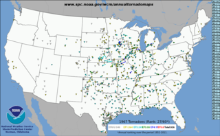
This page documents the tornadoes and tornado outbreaks of 1967, primarily in the United States. Most tornadoes form in the U.S., although some events may take place internationally. Tornado statistics for older years like this often appear significantly lower than modern years due to fewer reports or confirmed tornadoes.

<span class="mw-page-title-main">Tornadoes of 1958</span>

This page documents the tornadoes and tornado outbreaks of 1958, primarily in the United States. Most tornadoes form in the U.S., although some events may take place internationally. Tornado statistics for older years like this often appear significantly lower than modern years due to fewer reports or confirmed tornadoes.

<span class="mw-page-title-main">Tornadoes of 1957</span>

This page documents the tornadoes and tornado outbreaks of 1957, primarily in the United States. Most tornadoes form in the U.S., although some events may take place internationally. Tornado statistics for older years like this often appear significantly lower than modern years due to fewer reports or confirmed tornadoes.

<span class="mw-page-title-main">Tornadoes of 1956</span>

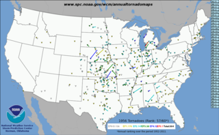
This page documents the tornadoes and tornado outbreaks of 1956, primarily in the United States. Most tornadoes form in the U.S., although some events may take place internationally. Tornado statistics for older years like this often appear significantly lower than modern years due to fewer reports or confirmed tornadoes.

<span class="mw-page-title-main">Tornadoes of 1955</span>

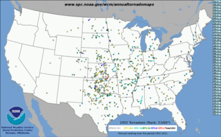
This page documents the tornadoes and tornado outbreaks of 1955, primarily in the United States. Most tornadoes form in the U.S., although some events may take place internationally. Tornado statistics for older years like this often appear significantly lower than modern years due to fewer reports or confirmed tornadoes.

Between April 23–30, 1961, a tornado outbreak sequence struck the Midwest, Ohio, and Mississippi Valleys, and the Eastern United States. Large hailstorms accompanied the tornadoes as well and numerous other weather events also occurred. Three people were killed, 38 others were injured and losses totaled $26.810 million. Two additional fatalities also occurred due to flooding and lightning.

This page documents the tornadoes and tornado outbreaks of 1946, primarily in the United States. Most recorded tornadoes form in the U.S., although some events may take place internationally. Tornado statistics for older years like this often appear significantly lower than modern years due to fewer reports or confirmed tornadoes.

References

  1. Arthur to Violet Hill, ON F3 Tornado of April 20, 1996 - Highways and Hailstones
  2. "Tornadoes – Atmospheric Hazards Web Site – Ontario – Adaptation and Impacts Research Group – [Meteorological Service of Canada – The Green Lane]". Archived from the original on 2011-07-28. Retrieved 2011-06-15.
  3. "Tornadoes – Atmospheric Hazards Web Site – Ontario – Adaptation and Impacts Research Group – [Meteorological Service of Canada – The Green Lane]". Archived from the original on 2011-07-28. Retrieved 2011-06-15.