2009 Australian dust storm

Last updated

2009 Australian dust storm
Dust storm over eastern Australia - MODIS Terra 250m - 23 Sept 2009.jpg
MODIS Terra satellite image of the dust storm over eastern Australia taken on 23 September 2009
Formed22 September 2009
Dissipated24 September 2009
FatalitiesNone
DamageNone
Areas affectedFlag of Australia (converted).svg  Australia
Flag of New Zealand.svg  New Zealand
Flags of New Caledonia.svg  New Caledonia, France

The 2009 Australian dust storm, also known as the Eastern Australian dust storm, was a dust storm that swept across the Australian states of New South Wales and Queensland from 22 to 24 September 2009. The capital, Canberra, experienced the dust storm on 22 September, [1] [2] and on 23 September the storm reached Sydney and Brisbane. Some of the thousands of tons of dirt and soil lifted in the dust storm were dumped in Sydney Harbour and the Tasman Sea.

Contents

On 23 September, the dust plume measured more than 500 kilometres (310 mi) in width and 1,000 kilometres (620 mi) in length and covered dozens of towns and cities in two states. [3] By 24 September, analysis using MODIS at NASA measured the distance from the northern edge at Cape York to the southern edge of the plume to be 3,450 km. [4] While the cloud was visible from space, on the ground the intense red-orange colour and drop in temperature drew comparisons with nuclear winter, Armageddon, and the planet Mars. [5] [6] [7]

The dust storm was described by the Bureau of Meteorology as a "pretty incredible event" that was the worst in the state of New South Wales in nearly 70 years. [5] [6] [8] [9] The phenomenon was reported around the world. The Weather Channel's Richard Whitaker said: "This is unprecedented. We are seeing earth, wind and fire together". It was later referred to as "The mother of all dust storms." [10]

Meteorological situation

First storm

Map of Australia and New Zealand showing the progress of the dust affected area and dust plume at various intervals 2009 Dust Storm - Australia and New Zealand Map.png
Map of Australia and New Zealand showing the progress of the dust affected area and dust plume at various intervals

According to the New South Wales regional director of the Bureau of Meteorology, Barry Hanstrum, the cause was an "intense north low-pressure area" which "picked up a lot of dust from the very dry interior of the continent". [11] Senior forecaster Ewan Mitchel said winds from a cold front picked up dust from north-east South Australia on 22 September. [12] That night the winds strengthened to 100 km per hour and collected more dust from areas in New South Wales that were drought affected. [12]

Air particle concentration levels reached 15,400 micrograms per cubic metre of air. Normal days register up to 20 micrograms and bushfires generate 500 micrograms. This concentration of dust broke records in many towns and cities. [13] The CSIRO estimated that the storm carried some 16 million tonnes of dust from the deserts of Central Australia, [14] and during the peak of the storm, the Australian continent was estimated to be losing 75,000 tonnes of dust per hour off the NSW coast north of Sydney. [15] The dust storm coincided with other extreme weather conditions which affected the cities of Adelaide and Melbourne.

The dust is believed to have originated from far-western New South Wales and north-east South Australia. This includes an area known as the 'Corner Country', [16] a dry, remote area of far-western New South Wales. In South Australia the dust may also have come from Lake Eyre Basin or the Woomera area, the latter raising concerns that it was radioactive and dangerous since the area contains the Olympic Dam uranium mine. [13]

Second dust storm

A second dust storm, originating in the same area but believed to be smaller, reached Broken Hill and Cobar by 10 pm on 25 September 2009. [17] This storm arrived in Sydney between 4 and 5 am on 26 September 2009, it pushed the EPA air quality index into the 'Poor to Hazardous' range. [18] However this was not as intense and had cleared by mid morning. The storm reached Brisbane on the evening of 26 September 2009, with the haze expected to clear by 28 September 2009. [19] On 29 November 2009, another minor dust storm occurred, which decreased visibility to 5 km over Sydney. [20]

Impacts

New South Wales and the Australian Capital Territory

The first city to be affected was Broken Hill, which was 'blacked out' at about 3:30 pm on 22 September 2009. At least one mine was shut down. [10] It was also witnessed in Cowra. The storm blew across Canberra and the surrounding region by midday on 23 September 2009, before being washed away by overnight rain, the heaviest rainfall over Canberra in months. [2]

It was reported that the dust set off smoke alarms across the state and prompted increased demand for emergency services. Asthma sufferers were hospitalised. [5] Rain was also reported to have resulted, [11] with cricket ball-sized hailstones falling. [6]

The dust storm also reached the north coast of NSW on the morning of 23 September 2009. Coffs Harbour was affected by 7 am. At Coffs Harbour Airport visibility was down to 500 metres by 9 am and the airport remained closed until 10:30 am. Grafton and the Clarence Valley were affected by 8:30 am. [16] [21] It caused flight delays at Ballina airport and flight cancellations for most of the day at Lismore airport with visibility at 700 metres. A local school rugby union carnival was also called off. [12]

Sydney

View of Sydney Harbour Bridge covered in dust. SHB-Red-Dust.jpg
View of Sydney Harbour Bridge covered in dust.

The storm caused severe disruption to international flights—several early morning Air New Zealand flights from Auckland, Christchurch and Wellington had to return to New Zealand after finding themselves unable to land at Sydney Airport. [22] These flights were listed as cancelled and many others were rescheduled to a later time. [23] 18 international flights were diverted to Melbourne Airport or Brisbane Airport, while six others were cancelled altogether. [5] [8] There were delays of six hours reported for overseas flights, whilst domestic flights experienced disruption of as much as three hours. [5]

Roads were disrupted, including the main tunnel of the M5 East Motorway which was shut down. Building sites were closed. [6] Ferry services were cancelled. [24] Canterbury Park Racecourse's scheduled day of horse racing was abandoned. [25]

Schools were disrupted as those children who attended were distracted by the dust storm, while many parents kept their children home. School trips and sports activities were cancelled for the day, and children were directed to stay inside during breaks in some schools. [26] Face masks experienced surging sales in Sydney as concerned residents rushed to protect themselves against the dust, with at least one retailer indicating she had sold more than during the swine flu pandemic. [27]

Queensland

Dust storm at Surfers Paradise beach (looking south) 20090923 - Dust Storm - Surfers Paradise (looking south).JPG
Dust storm at Surfers Paradise beach (looking south)

Residents of Windorah in South West Queensland reported low visibility on the morning of 22 September. [28] By 23 September visibility in Toowoomba and Ipswich in South East Queensland was reduced to 100 metres (330 ft). [29]

Brisbane was affected by the dust storm, although low visibility was less of a problem at Brisbane Airport than it was at Sydney. [30]

The Gold Coast was also severely affected by the dust storm by 11.30 am, reducing visibility to 500 metres (1,600 ft). Work stopped at construction sites due to health concerns, powerlines were down in some areas, the Q-deck was closed and traffic was slow with motorists using headlights. False fire alarms resulted in the evacuation of the Southport Magistrates Court. Flights were able to depart but incoming flights were diverted. [31] The beaches remained open with added 'no swimming' flags in unpatrolled areas. Two fishermen off the coast of South Stradbroke Island were lost and a helicopter was required to locate them. [32] [33]

The dust storm reached Central and North Queensland by the evening of 23 September 2009. However the effect was less serious, with visibility between 50 and 7,000 metres. Commercial flights were not disrupted. Affected areas include Townsville, Blackwater, Rockhampton, [34] Mackay, [35] Cairns and the Gulf of Carpentaria (Normanton and Kowanyama). [36]

New Zealand

Red dust from the storm reached New Zealand on the morning of 25 September 2009, behind a weather front that brought cold temperatures to the North Island. It was observed by satellite, atmospheric monitoring equipment (a beta attenuation monitor) at Auckland International Airport and by dust settling on the ground. Dust settled across Auckland as well as in the Northland, Waikato, Bay of Plenty and Taranaki districts of the North Island and it also reached the South Island's West Coast. [37] [38] [39] [40]

Roger Deakins, cinematographer of the film Blade Runner 2049 , has stated that images of the dust storm in Sydney directly inspired the film's Las Vegas scenes.

With Las Vegas, Denis [ Villeneuve] wanted it to have the red dust. We discussed it at length and we came up with these images of Sydney during the dust storm that they had a few years ago. There are these wonderful photos of the Sydney Opera House and it’s covered with red dust. That formed the basis for Las Vegas. [41]

Related Research Articles

<span class="mw-page-title-main">Transport in Australia</span> Overview of the transport in Australia

There are many forms of transport in Australia. Australia is highly dependent on road transport. There are more than 300 airports with paved runways. Passenger rail transport includes widespread commuter networks in the major capital cities with more limited intercity and interstate networks. The Australian mining sector is reliant upon rail to transport its product to Australia's ports for export.

<span class="mw-page-title-main">Charles Kingsford Smith</span> Australian aviator (1897–1935)

Sir Charles Edward Kingsford Smith, nicknamed Smithy, was an Australian aviation pioneer. He piloted the first transpacific flight and the first flight between Australia and New Zealand.

Rex Airlines Pty Ltd is an Australian airline based in Mascot, New South Wales. It operates scheduled regional and domestic services. It is Australia's largest regional airline outside the Qantas group of companies and serves all 6 states across Australia. It is the primary subsidiary of Regional Express Holdings.

QantasLink is a regional airline brand of Australian airline Qantas and is an affiliate member of the Oneworld airline alliance. It is a major competitor to Regional Express Airlines and Virgin Australia Regional Airlines. As of September 2010 QantasLink provided 1,900 flights each week to 54 domestic locations.

<span class="mw-page-title-main">South East Queensland</span> Region in southern Queensland, Australia

South East Queensland (SEQ) is a bio-geographical, metropolitan, political and administrative region of the state of Queensland in Australia, with a population of approximately 3.8 million people out of the state's population of 5.1 million. The area covered by South East Queensland varies, depending on the definition of the region, though it tends to include Queensland's three largest cities: the capital city Brisbane; the Gold Coast; and the Sunshine Coast. Its most common use is for political purposes, and covers 35,248 square kilometres (13,609 sq mi) and incorporates 11 local government areas, extending 240 kilometres (150 mi) from Noosa in the north to the Gold Coast and New South Wales border in the south, and 140 kilometres (87 mi) west to Toowoomba.

<span class="mw-page-title-main">Severe storms in Australia</span> Major weather events

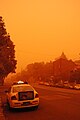
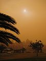
Severe storms in Australia refers to the storms, including cyclones, which have caused severe damage in Australia. For comparison, a comprehensive list of all damaging storms can be found on the Australian Bureau of Meteorology website.

<span class="mw-page-title-main">Albury Airport</span> Airport

Albury Airport is a regional airport located 2 nautical miles northeast Albury, New South Wales, Australia. The airport, which also serves Albury's adjacent twin city of Wodonga, Victoria was the fifth busiest in New South Wales as of 2016–17 handling 257,769 passengers. However like most Australian airports, the impacts of travel restrictions and state border closures in response to the COVID-19 pandemic resulted in a significant reduction in revenue passengers. ABX handled 107,934 passengers in the 2021–22 Financial Year and was the 32nd busiest airport in Australia. In addition to regular public transport flights, Albury airport handles a relatively large number of charter, freight, agricultural, and general aviation aircraft movements and hosts the official weather station for Albury-Wodonga.

<span class="mw-page-title-main">Whitsunday Coast Airport</span> Airport in Queensland, Australia

Whitsunday Coast Airport, also known as Proserpine Airport, is located in Gunyarra, Whitsunday Region, Queensland, Australia, 14 kilometres (8.7 mi) south of Proserpine. The airport serves the mainland and offshore islands with flights to Brisbane, Sydney and Melbourne.

<span class="mw-page-title-main">Climate of Sydney</span> Climate of the city in Australia

The climate of the city of Sydney, Australia is humid subtropical, shifting from mild and cool in winter to warm and hot in the summer, with no extreme seasonal differences as the weather is moderated by proximity to the ocean, although more contrasting temperatures are recorded in the inland western suburbs. Despite the fact that there is no distinct dry or wet season, rainfall peaks in the first few months of the year and is at its lowest just around the middle of the year, though precipitation can be erratic throughout the year. Precipitation varies across the region, with areas adjacent to the coast being the wettest. According to the Bureau of Meteorology, Sydney falls in the temperate climate zone which has warm to hot summers and no dry season. Sydney's plant hardiness zone ranges from zone 11a to 9b throughout the metropolitan area.

<span class="mw-page-title-main">Drought in Australia</span> Rainfall deficiency in Australia

Drought in Australia is defined by the Australian Bureau of Meteorology as rainfall over period greater than three-months being in the lowest decile of what has been recorded for that region in the past. This definition takes into account that drought is a relative term and rainfall deficiencies need to be compared to typical rainfall patterns including seasonal variations. Specifically, drought in Australia is defined in relation to a rainfall deficiency of pastoral leases and is determined by decile analysis applied to a certain area. Note that this definition uses rainfall only because long-term records are widely available across most of Australia. However, it does not take into account other variables that might be important for establishing surface water balance, such as evaporation and condensation.

<span class="mw-page-title-main">1999 Sydney hailstorm</span> 1999 storm in Australia

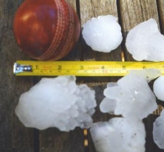
The 1999 Sydney hailstorm was the costliest natural disaster in Australian insurance history, causing extensive damage along the east coast of New South Wales. The storm developed south of Sydney on the afternoon of Wednesday, 14 April 1999, and struck the city's eastern suburbs, including the central business district, later that evening.

The following lists events that happened during 2009 in Australia.

Australian rivers have been subject to devastating floods in New South Wales, recorded since colonisation. Flooding in New South Wales has predominately been caused by excessive flows into rivers located in New South Wales and, to a lesser extent, excessive flows into rivers located in Queensland and Victoria. Floods can devastate local communities and impact the entire local economy.

<span class="mw-page-title-main">Cyclone Oswald</span> 2013 tropical cyclone that struck Australia

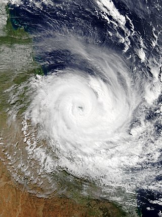
Tropical Cyclone Oswald in 2013 was a tropical cyclone that passed over parts of Queensland and New South Wales, Australia over a number of days, causing widespread impact including severe storms, flooding, and water spouts. Coastal regions of Queensland were the most impacted with Mundubbera, Eidsvold, Gayndah and Bundaberg in the Wide Bay–Burnett hit severely. In many places the rainfall total for January set new records. Across the affected region, damage from severe weather and flooding amounted to at least A$2.4 billion.

<span class="mw-page-title-main">Australian east coast low</span>

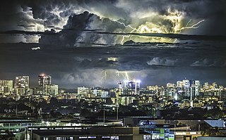
Australian east coast lows are extratropical cyclones or low-pressure systems on the coast of southeastern Australia that may be caused by both mid-latitude and tropical influences over a variety of levels in the atmosphere.

<span class="mw-page-title-main">Cyclone Debbie</span> Category 4 Australian region Tropical cyclone in 2017

Severe Tropical Cyclone Debbie in 2017 was the strongest tropical cyclone to strike Queensland since Marcia in 2015, and was the costliest tropical cyclone in Australia since Yasi in 2011. Forming as a tropical low on 23 March, the low gradually intensified into a named tropical cyclone on 25 March. After steadily strengthening offshore to a Category 4 system, Debbie eventually made landfall near Airlie Beach, at 12:40 AEST on 28 March. Afterwards, Debbie rapidly weakened into a tropical low by late 28 March, but continued to travel south, causing significant damage and flooding in the populous areas of South East Queensland and Northern Rivers. In total, the storm caused A$3.5 billion (US$2.67 billion) in damage and fourteen deaths across Australia, primarily as a result of extreme flooding. This makes Debbie the deadliest cyclone to hit Australia since Fifi in 1991.

<span class="mw-page-title-main">Black nor'easter</span>

A Black nor'easter is a persistent and potentially violent north-easterly storm that occurs on the east coast of Australia usually between late spring and early autumn, about two days a year, although not a convection wind, but a storm system that develops offshore which can last several days. This is heralded by the rapid build-up of dense black cloud that can convert to a gale in well under one hour, and also bringing with it a heavy rainfall event usually accompanied by a thunderstorm. This type of storm was first recorded during the 1800s.

<span class="mw-page-title-main">2021 eastern Australia floods</span> Series of disastrous floods in Australia

Extreme rainfall on the east coast of Australia beginning on 18 March 2021 led to widespread flooding in New South Wales, affecting regions from the North Coast to the Sydney metropolitan area in the south. Suburbs of Sydney experienced the worst flooding in 60 years, and the events were described by NSW Premier Gladys Berejiklian as "one in 100-year" flooding. Far-southeast communities in Queensland were also affected by flooding and heavy rainfall, though to a lesser extent than those in New South Wales.

This article documents the chronology and epidemiology of SARS-CoV-2, the virus which causes the coronavirus disease 2019 (COVID-19) and is responsible for the COVID-19 pandemic in Australia during the first half of 2021.

<span class="mw-page-title-main">2022 eastern Australia floods</span> February-April disaster in New South Wales and Queensland

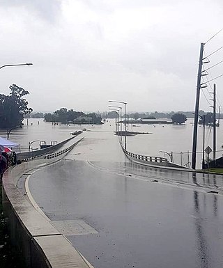
The 2022 eastern Australia floods were one of the nation's worst recorded flood disasters with a series of floods that occurred from February to April in South East Queensland, the Wide Bay–Burnett and parts of coastal New South Wales. Brisbane suffered major flooding, along with the cities of Maryborough, Gympie, the Sunshine Coast, Caboolture, Toowoomba, Gatton, Ipswich, Logan City, the Gold Coast, Murwillumbah, Mullumbimby, Grafton, Byron Bay, Ballina, Lismore, the Central Coast and parts of Sydney.

References

  1. Penny McLintock (22 September 2009). "Canberra disappears in the dust". ABC News . Archived from the original on 27 September 2009. Retrieved 23 September 2009.
  2. 1 2 Megan Doherty (23 September 2009). "Dust, hail and deluge". The Canberra Times . Archived from the original on 27 September 2009. Retrieved 23 September 2009.
  3. Largest dust storms in 70 years cover Sydney The Daily Telegraph
  4. "Dust over Eastern Australia". NASA – Earth Observatory. 25 September 2009. Archived from the original on 30 October 2009. Retrieved 25 September 2009.
  5. 1 2 3 4 5 Nichola Saminather and Ed Johnson (23 September 2009). "Sydney Hit by 'Nuclear Winter' as Dust Storm Envelops City". Bloomberg . Retrieved 23 September 2009.
  6. 1 2 3 4 Toni O'Loughlin (23 September 2009). "Australia engulfed by dust storms". The Guardian . London. Retrieved 23 September 2009.
  7. Ian Woods (23 September 2009). "Giant Dust Storm Causes Havoc in Sydney". Sky News . Retrieved 23 September 2009.
  8. 1 2 "Melbourne Airport warns of delays". ABC News . 23 September 2009. Retrieved 23 September 2009.
  9. "Sydney dust storm worst in 70 years, says weather bureau". The Australian . 23 September 2009. Archived from the original on 27 September 2009. Retrieved 23 September 2009.
  10. 1 2 "Severe dust storm sweeps Australia". RTÉ. 23 September 2009. Retrieved 23 September 2009.
  11. 1 2 Madelene Pearson (23 September 2009). "Australian Weather Event Brings Rain to New South Wales Crops". Bloomberg . Retrieved 23 September 2009.
  12. 1 2 3 "North Coast chokes in dust". The Northern Star. Lismore, Queensland: APN News & Media Ltd. 24 September 2009. Archived from the original on 27 September 2009. Retrieved 25 September 2009.
  13. 1 2 Roberts, Greg (25 September 2009). "Are the dust storms radioactive?". news.com.au. News Limited. Archived from the original on 28 September 2009. Retrieved 26 September 2009.
  14. "16 megaton D-bomb". The Gold Coast Bulletin. News Limited. 24 September 2009. pp. 1 to 5. Archived from the original on 13 September 2009. Retrieved 27 September 2009.
  15. Leys, J., Heidenreich, S. and Case, M. 2009. DustWatch interim report 22–23 September. DustWatch is funded by the Lower Murray Darling, Lachlan, and Murray CMAs, the Department of Environment, Climate Change and Water NSW and Griffith University.
  16. 1 2 "Welcome to Coughs Harbour". The Coffs Coast Advocate. Coffs Harbour, Queensland: APN News & Media Ltd. 24 September 2009. Archived from the original on 6 July 2011. Retrieved 25 September 2009.
  17. "Dust storm heading towards Sydney". news.com.au. Australia: News Limited. 26 September 2009. Archived from the original on 28 September 2009. Retrieved 26 September 2009.
  18. NSW DECC (26 September 2009). "Hourly Air quality index". Air quality update. New South Wales Government – Department of Environment Climate Change and Water. Archived from the original on 9 July 2009. Retrieved 26 September 2009.
  19. "Second dust storm sweeps through Qld". The Sydney Morning Herald . 27 September 2009. Archived from the original on 31 December 2013. Retrieved 29 December 2013.
  20. Sydney swelters in record November heat by BOM
  21. "Dust storm hits Northern NSW". ABC Online. 23 September 2009. Archived from the original on 26 September 2009. Retrieved 24 September 2009.
  22. "Air NZ flights turn back as Sydney morphs into Mars". National Business Review . 23 September 2009. Archived from the original on 26 September 2009. Retrieved 23 September 2009.
  23. Michael Janda (23 September 2009). "Flight delays remain as dust settles in Sydney". ABC News . Archived from the original on 26 September 2009. Retrieved 23 September 2009.
  24. "Red dust cloud covers Sydney". BBC. 23 September 2009. Archived from the original on 23 September 2009. Retrieved 23 September 2009.
  25. Nichola Saminather and Rebecca Keenan (23 September 2009). "Giant dust storm blankets Sydney". Irish Independent . Retrieved 23 September 2009.
  26. Inga Ting (23 September 2009). "Red dust storm: half-empty classrooms and missed excursions". The Sydney Morning Herald . Retrieved 23 September 2009.
  27. Inga Ting (23 September 2009). "Red dust: face masks flying off the shelves". The Sydney Morning Herald . Retrieved 23 September 2009.
  28. Brian Williams, Peter Morley and Leanne Edmistone (24 September 2009). "Dust storm, worst in 70 years, expected to head north". Courier Mail . Queensland Newspapers . Retrieved 24 September 2009.
  29. Arjun Ramachandran (23 September 2009). "Brisbane CBD dusted: Sydney storm heads north". theage.com.au . Melbourne: Fairfax Digital . Retrieved 24 September 2009.
  30. Conal Hanna (23 September 2009). "Brisbane awakes from haze as dust settles". Brisbane Times . Archived from the original on 30 September 2009. Retrieved 23 September 2009.
  31. "Dust descends on Gold Coast". Gold Coast Bulletin. Archived from the original on 26 September 2009. Retrieved 23 September 2009.
  32. "Sydney breathes again as dust covers Brisbane". ABC News . 23 September 2009. Retrieved 23 September 2009.
  33. "Dust storm engulfs southern Qld". Yahoo News. Archived from the original on 28 September 2009.
  34. "Storm arrives dust in time for tea". The Morning Bulletin. Rockhampton, Queensland: APN News & Media. 24 September 2009. Archived from the original on 28 September 2009. Retrieved 25 September 2009.
  35. "Fire fear follows in dust's wake". Daily Mercury. Mackay, Queensland: APN News & Media. 25 September 2009. Archived from the original on 10 October 2009. Retrieved 25 September 2009.
  36. "Dust clouds Cairns". The Cairns Post. Cairns, Queensland: News Limited. 24 September 2009. Archived from the original on 22 July 2011. Retrieved 25 September 2009.
  37. "Storm's red dust reaches NZ". The New Zealand Herald. New Zealand: APN Holdings NZ Limited. 25 September 2009. Archived from the original on 21 October 2012. Retrieved 25 September 2009.
  38. "Desert storm hits Taranaki". Taranaki Daily News. Taranaki, New Zealand: Fairfax. 25 September 2009. Retrieved 25 September 2009.
  39. "Australian dust storm arrives in New Zealand". news.com.au. Wellington, New Zealand: News Limited. 25 September 2009. Archived from the original on 5 October 2009. Retrieved 26 September 2009.
  40. "Aussie Outback dust smothers the Coast". Greymouth Star. Retrieved 25 September 2009.
  41. Tapley, Kristopher (4 October 2017). "Roger Deakins on 'Blade Runner 2049' and That Elusive First Oscar" . Retrieved 19 August 2018.

See also

Related article

Coordinates: 35°18′25″S149°07′26″E / 35.307°S 149.124°E / -35.307; 149.124 (Canberra)