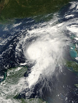
Hurricane Opal was a large and powerful Category 4 hurricane that caused severe and extensive damage along the northern Gulf Coast of the United States in October 1995. The fifteenth named storm, ninth hurricane and strongest tropical cyclone of the unusually active 1995 Atlantic hurricane season, Opal developed from the interaction of a tropical wave and a low-pressure area near the Yucatán Peninsula on September 27 as Tropical Depression Seventeen. The depression crossed the Yucatán Peninsula and intensified into a tropical storm on September 30. Opal intensified into a hurricane on October 2 after entering the Gulf of Mexico. The cyclone turned northeastward and strengthened significantly. By October 4, Opal was an intense 150 mph (240 km/h), Category 4 hurricane. With a minimum pressure of 916 mbar (hPa), Hurricane Opal was the most intense category 4 Atlantic hurricane on record. However, the cyclone abruptly weakened to a low-end Category 3 hurricane prior to making landfall on the Florida Panhandle near Pensacola later that day. The storm quickly unraveled as it moved inland and became extratropical on October 5. The remnants of Opal moved northward and dissipated over Ontario the following day.

The Grand Rapids Press is a daily newspaper published in Grand Rapids, Michigan. It is the largest of the eight Booth newspapers. It is sold for $1.50 daily and $7.99 on Sunday.
John Hoult Logie was an American attorney and politician who served as mayor of Grand Rapids, Michigan from 1992 to 2003, one of the longest-serving in the city's history.

In October 2005, remnants of Tropical Storm Tammy and Subtropical Depression Twenty-Two merged with incoming continental cold fronts to produce torrential rains over interior New England, as well as over parts of New Jersey and New York. Particularly hard hit was the state of New Hampshire, which saw roads and bridges wiped out, several reported deaths, and whole buildings destroyed. Rain lingered over some areas for several weeks. Rainfall from both rain events totaled well over 20 inches (510 mm) in some areas.
Hurricane Gordon caused minor damage in the Eastern United States. The seventh named storm and fourth hurricane of the 2000 Atlantic hurricane season, Gordon developed in the extreme western Caribbean Sea from a tropical wave on September 14. Shortly thereafter, the depression moved inland over the Yucatán Peninsula and later emerged into the Gulf of Mexico on September 15. The depression began to quickly organize, and by early on September 16, it was upgraded to Tropical Storm Gordon. After becoming a tropical storm, Gordon continued to intensify and was reclassified as a hurricane about 24 hours later; eventually, the storm peaked as an 80 mph (130 km/h) Category 1 hurricane. However, southwesterly upper-level winds caused Gordon to weaken as it approached land, and it was downgraded to a tropical storm by late on September 17. At 0300 UTC on September 18, Gordon made landfall near Cedar Key, Florida as a strong tropical storm. After moving inland, Gordon rapidly weakened and had deteriorated to tropical depression status by nine hours later. Later that day, Gordon merged with a frontal boundary while centered over Georgia.

Tropical Storm Claudette was a 1979 tropical cyclone which was the third-wettest tropical cyclone on record in the contiguous United States. The storm caused significant flooding in eastern Texas and western Louisiana in July 1979. The eighth tropical cyclone and third named storm of the 1979 Atlantic hurricane season, Claudette developed from a tropical wave located east of the Windward Islands on July 16. It gradually strengthened and was upgraded to a tropical storm on July 17 and crossed the northern Leeward Islands later that day. As it neared landfall in Puerto Rico early on July 18, upper-level winds weakened it back to a tropical depression. Claudette remained disorganized and the National Hurricane Center operationally reported that it degenerated back into a tropical wave after crossing Puerto Rico. Late on July 18, the depression struck Dominican Republic, emerged into the Caribbean Sea on the following day. Claudette struck western Cuba on July 21, shortly before reaching the Gulf of Mexico and "regenerating" into a tropical cyclone. By July 23, Claudette regained tropical storm intensity and turned northward toward the Gulf Coast of the United States. The storm made landfall near the Texas-Louisiana border late on July 23 as a moderately strong tropical storm. It weakened slowly and drifted over land, lasting until dissipation in West Virginia on July 29.

The Pawtuxet River, also known as the Pawtuxet River Main Stem and the Lower Pawtuxet, is a river in the U.S. state of Rhode Island. It flows 12.3 miles (19.8 km) and empties into the upper Narragansett Bay of the Atlantic Ocean. Together with its two main tributary branches, the North Branch Pawtuxet River and the South Branch Pawtuxet River, it drains a watershed of 231.6 square miles (600 km2), all of which is in the state of R.I.
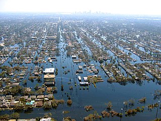
Floods in the United States are generally caused by excessive rainfall, excessive snowmelt, and dam failure. Below is a list of flood events that were of significant impact to the country during the 20th century, from 1900 through 1999, inclusive.

M-231 is the designation of a state trunkline highway in the Lower Peninsula of the US state of Michigan that serves as a partial bypass to US Highway 31 (US 31) around Grand Haven. This highway was built south of Interstate 96 (I-96) as an additional crossing over the Grand River. The route runs from M-45 northward and across the river to a connection with I-96 near the current M-104 interchange.
Floods in the United States (2000–present) is a list of flood events which were of significant impact to the country during the 21st century, since 2000. Floods are generally caused by excessive rainfall, excessive snowmelt, storm surge from hurricanes, and dam failure.

The June 2008 Midwestern United States floods were flooding events which affected portions of the Midwestern United States. After months of heavy precipitation, a number of rivers overflowed their banks for several weeks at a time and broke through levees at numerous locations. Flooding continued into July. States affected by the flooding included Illinois, Indiana, Iowa, Michigan, Minnesota, Missouri and Wisconsin. The American Red Cross assisted the victims of flooding and tornadoes across seven states and the National Guard was mobilized to assist in disaster relief and evacuation.

The JW Marriott Grand Rapids is a hotel located in downtown Grand Rapids, Michigan. It was the first JW Marriott Hotel in the Midwest and is the sixth tallest building in Grand Rapids. Its theme is based on Grand Rapids's sister cities: Omihachiman, Japan; Bielsko-Biala, Poland; Perugia, Italy; Ga District, Ghana; and Zapopan, Mexico. When the hotel was first opened, Amway Hotel Corporation hired photographer Dan Watts to travel to each of the sister cities and photograph them for the property. Each floor of the hotel features photography from one of the cities and is unique to that floor.

The 2010 Tennessee floods were floods in Middle Tennessee, West Tennessee, south-central and western Kentucky and northern Mississippi areas of the United States of America as the result of torrential rains on May 1 and 2, 2010. Floods from these rains affected the area for several days afterwards, resulting in a number of deaths and widespread property damage.

Plaza Towers is a mixed-use highrise building in Grand Rapids, Michigan. At 345 feet (105 m), it was the tallest building in the city until the completion of the River House Condominiums in 2008. The building contains apartments on floors 8–14, individually owned condominiums on floors 15–32, and a 214-room Courtyard by Marriott hotel on floors 1–7.

Brandon Dillon is an American politician. He is the former Chair of the Michigan Democratic Party.
Rosalynn Bliss is an American politician, social worker, and mayor of Grand Rapids, Michigan. The first woman to be elected mayor of Michigan's second-largest city, Bliss took office on January 1, 2016. She has served on the Grand Rapids City Commission since 2006. Bliss is a member of the Democratic Party.

The 2015 Grand Rapids mayoral election took place on August 4, 2015 to elect the Mayor of Grand Rapids, Michigan. It saw the election of Rosalynn Bliss.

An extremely powerful extratropical bomb cyclone began in late October 2021 in the Northeast Pacific and struck the Western United States and Western Canada. The storm was the third and the most powerful cyclone in a series of powerful storms that struck the region within a week. The cyclone tapped into a large atmospheric river and underwent explosive intensification, becoming a bomb cyclone on October 24. The bomb cyclone had a minimum central pressure of 942 millibars (27.8 inHg) at its peak, making it the most powerful cyclone recorded in the Northeast Pacific. The system had severe impacts across Western North America, before dissipating on October 26. The storm shattered multiple pressure records across parts of the Pacific Northwest. Additionally, the bomb cyclone was the most powerful storm on record to strike the region, in terms of minimum central pressure. The bomb cyclone brought powerful gale-force winds and flooding to portions of Western North America. At its height, the storm cut the power to over 370,500 customers across the Western U.S. and British Columbia. The storm killed at least two people; damage from the storm was estimated at several hundred million dollars. The bomb cyclone was compared to the Columbus Day Storm of 1962, in terms of ferocity.

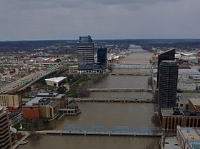
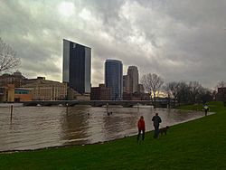
In April 2013, persistent heavy rains caused widespread flooding, primarily impacting the Midwestern and Great Lakes regions. In a span of two days on April 17 and 18, heavy rainfall associated with a slow-moving storm system caused widespread flooding across rivers and areas, where rainfall amounts over 8 inches (200 mm) caused rivers to swell and crest, including the Mississippi River and the Red River, with the latter river dealing with melting ice caps. The Grand River crested to a record level, prompting water rescues and evacuations in Grand Rapids, Michigan. A local state of emergency was declared for the city of Des Plaines, Illinois after the Des Plaines river swelled to 10.92 feet (3,330 mm). The governors of Illinois and Missouri declared state of emergencies, and the Federal Emergency Management Agency declared a federal emergency and a disaster declaration for 46 counties in Illinois. Five fatalities occurred: two each in Illinois and Indiana, with a fifth in Missouri. Three others were injured, all in Illinois.