2014 West Salt Creek landslide

Last updated
Aerial view of the landslide, looking south towards Grand Mesa West-salt-creek-slide.jpeg
Aerial view of the landslide, looking south towards Grand Mesa

The West Salt Creek landslide (also known as the Grand Mesa landslide or West Salt Creek rock avalanche) occurred on the evening of May 25, 2014 near Collbran, Colorado, along the north side of the Grand Mesa, about 30 miles (48 km) east of Grand Junction. It was the largest landslide in Colorado's history. [1]

Collbran, Colorado Statutory Town in State of Colorado, United States

The Town of Collbran is a Statutory Town in Mesa County, Colorado, United States. The town population was 708 at the 2010 United States Census. Collbran is a part of the Grand Junction, CO Metropolitan Statistical Area. The town is located east of Grand Junction along Plateau Creek, at the upper (eastern) end of the small cattle ranching valley around the creek known as the Plateau Valley. The largest community in the valley, it serves a civic and economic center for the surrounding area, which is dependent not only ranching, but on pass-through tourism during the summer and autumn months. In the latter capacity, the town acts somewhat as a gateway to nearby Vega State Park and other recreational sites along the northeast side of the Grand Mesa via the Grand Mesa Scenic and Historic Byway.

Colorado State of the United States of America

Colorado is a state of the Western United States, and more specifically of the Southwestern United States, encompassing most of the southern Rocky Mountains as well as the northeastern portion of the Colorado Plateau and the western edge of the Great Plains. It is the 8th most extensive and 21st most populous U.S. state. The estimated population of Colorado was 5,695,564 on July 1, 2018, an increase of 13.25% since the 2010 United States Census.

Grand Mesa mountain

The Grand Mesa is a large mesa in western Colorado in the United States. It is the largest flat-topped mountain in the world. It has an area of about 500 square miles (1,300 km2) and stretches for about 40 miles (64 km) east of Grand Junction between the Colorado River and the Gunnison River, its tributary to the south. The north side of the mesa is drained largely by Plateau Creek, a smaller tributary of the Colorado. The west side is drained largely by Kannah Creek, which is received to the west by the lower Gunnison River. The mesa rises about 6,000 feet (1,800 m) above the surrounding river valleys, including the Grand Valley to the west, reaching an elevation of about 11,000 feet (3,400 m). Much of the mesa is within Grand Mesa National Forest. Over 300 lakes, including many reservoirs created and used for drinking and irrigation water, are scattered along the top of the formation. The Grand Mesa is flat in some areas, but quite rugged in others.

Contents

Background

West Salt Creek is located on the north slope of the Grand Mesa, descending steeply from about 10,000 feet (3,000 m) elevation at the top of the mountain to about 7,400 feet (2,300 m) in the Plateau Valley. Via Plateau Creek, it is a tributary of the Colorado River. [2] The valley of West Salt Creek was used mainly for cattle ranching and was mostly private property owned by the Hawkins family. [3] However, the area where the slide originated was located on public land in the Grand Mesa National Forest. [4]

Plateau Creek (Colorado) river in the United States of America

Plateau Creek is a tributary of the Colorado River, approximately 50 miles (80 km) long, located in western Colorado in the United States. It drains a cattle ranching valley, known as Plateau Valley, north of the Grand Mesa and east of Grand Junction.

Colorado River major river in the western United States and Mexico

The Colorado River is one of the principal rivers in the Southwestern United States and northern Mexico. The 1,450-mile-long (2,330 km) river drains an expansive, arid watershed that encompasses parts of seven U.S. and two Mexican states. Starting in the central Rocky Mountains of Colorado, the river flows generally southwest across the Colorado Plateau and through the Grand Canyon before reaching Lake Mead on the Arizona–Nevada border, where it turns south toward the international border. After entering Mexico, the Colorado approaches the mostly dry Colorado River Delta at the tip of the Gulf of California between Baja California and Sonora.

Grand Mesa National Forest

The Grand Mesa National Forest is a U.S. National Forest in Mesa, Delta and Garfield Counties in Western Colorado. It borders the White River National Forest to the north and the Gunnison National Forest to the east. The forest covers most of Grand Mesa and the south part of Battlement Mesa. It has a total area of 346,555 acres. It is managed by the United States Forest Service together with Gunnison National Forest and Uncompahgre National Forest from offices in Delta, Colorado. There are local ranger district offices located in Grand Junction.

The landslide was caused by a mass wasting event in the Green River Formation, which is composed mainly of loose sedimentary rock, namely shale. The U.S. Geological Survey (USGS) determined that the event occurred on the site of an ancient landslide dating back to the late Pleistocene or early Holocene, at least 11,700 years ago. [5] Such geological features are not uncommon to this area of the Grand Mesa, [6] which exhibits a "landslide bench" where creep rates of 1.5 to 6 inches (38 to 152 mm) per year have been previously documented. [7]

Mass wasting geomorphic process by which soil, sand, regolith, and rock move downslope

Mass wasting, also known as slope movement or mass movement, is the geomorphic process by which soil, sand, regolith, and rock move downslope typically as a solid, continuous or discontinuous mass, largely under the force of gravity, but frequently with characteristics of a flow as in debris flows and mudflows. Types of mass wasting include creep, slides, flows, topples, and falls, each with its own characteristic features, and taking place over timescales from seconds to hundreds of years. Mass wasting occurs on both terrestrial and submarine slopes, and has been observed on Earth, Mars, Venus, and Jupiter's moon Io.

Green River Formation geologic formation

The Green River Formation is an Eocene geologic formation that records the sedimentation in a group of intermountain lakes in three basins along the present-day Green River in Colorado, Wyoming, and Utah. The sediments are deposited in very fine layers, a dark layer during the growing season and a light-hue inorganic layer in the dry season. Each pair of layers is called a varve and represents one year. The sediments of the Green River Formation present a continuous record of six million years. The mean thickness of a varve here is 0.18 mm, with a minimum thickness of 0.014 mm and maximum of 9.8 mm.

Shale A fine-grained, clastic sedimentary rock

Shale is a fine-grained, clastic sedimentary rock composed of mud that is a mix of flakes of clay minerals and tiny fragments of other minerals, especially quartz and calcite. Shale is characterized by breaks along thin laminae or parallel layering or bedding less than one centimeter in thickness, called fissility. It is the most common sedimentary rock.

Initial landslide

Unseasonably heavy rains during May 23–24 melted the local snowpack and saturated the ground to the point of instability. [8] A small landslide was recorded at approximately 7:18 AM on May 25, and minor slope movement was noticed throughout the day. [9] At 5:44 PM on May 25 [10] a large chunk of the West Salt Creek valley headwall (known as the "slump block") collapsed catastrophically. [11] The initial collapse triggered a wave of subsequent rock failures (a "rock avalanche") that moved 2.8 miles (4.5 km) down the valley of West Salt Creek, burying almost 600 acres (240 ha) of land under 38 million yd3 (29 million m3) of debris. [1] The average speed of the landslide was about 45 miles (72 km) per hour, [6] with a maximum of 75 to 140 miles (121 to 225 km) per hour, [9] and its maximum depth reached 123 feet (37 m). [5] The slide descended a total of 2,300 feet (700 m) from the rim of the Grand Mesa to the valley below. [11] The speed of the slide was likely increased by a layer of liquefied material underneath the main rock avalanche. [7] Residents described the sound of the landslide as “a low flying, large military helicopter”, "a very long clap of thunder", or “a freight train coming”. [6]

In physical geography and geology the headwall of a glacial cirque is its highest cliff. The term has been more broadly used to describe similar geomorphic features of non-glacial origin consisting of a concave depression with convergent slopes typically of 65 percent or greater forming the upper end of a drainage valley.

The landslide generated a Mw 2.8 earthquake, [9] destroyed irrigation works and threatened active gas wells in the area, but did not reach Collbran, about 6 miles (9.7 km) further downstream from the toe of the slide. [1] Although the initial slide lasted only about three minutes, [3] a second debris flow occurred on top of the initial slide, followed by a further collapse of the downslope face of the slide. [6] Smaller landslides and slope failures continued for several weeks after the disaster, bringing the total volume of collapsed material to 71.2 million yd3 (54.5 million m3). [6] This makes it much larger than the Oso landslide which occurred two months previously in northern Washington. [8] Vibrations from the slide were recorded by seismographs up to 400 miles (640 km) away. [12]

The moment magnitude scale is a measure of n earthquake's magnitude based on its seismic moment, expressed in terms of the familiar magnitudes of the original "Richter" magnitude scale.

Debris flow

Debris flows are geological phenomena in which water-laden masses of soil and fragmented rock rush down mountainsides, funnel into stream channels, entrain objects in their paths, and form thick, muddy deposits on valley floors. They generally have bulk densities comparable to those of rock avalanches and other types of landslides, but owing to widespread sediment liquefaction caused by high pore-fluid pressures, they can flow almost as fluidly as water. Debris flows descending steep channels commonly attain speeds that surpass 10 m/s, although some large flows can reach speeds that are much greater. Debris flows with volumes ranging up to about 100,000 cubic meters occur frequently in mountainous regions worldwide. The largest prehistoric flows have had volumes exceeding 1 billion cubic meters. As a result of their high sediment concentrations and mobility, debris flows can be very destructive.

Washington (state) State of the United States of America

Washington, officially the State of Washington, is a state in the Pacific Northwest region of the United States. Named for George Washington, the first president of the United States, the state was made out of the western part of the Washington Territory, which was ceded by Britain in 1846 in accordance with the Oregon Treaty in the settlement of the Oregon boundary dispute. It was admitted to the Union as the 42nd state in 1889. Olympia is the state capital; the state's largest city is Seattle. Washington is sometimes referred to as Washington State, to distinguish it from Washington, D.C., the capital of the United States, which is often shortened to Washington.

Dispatchers in Grand Junction received the first reports of the landslide around 6:15 PM, and the Plateau Valley Fire Department was called into the area. [13] Three people – Wes Hawkins, Clancy Nichols and Danny Nichols – were reported missing after heading into the area to investigate an irrigation ditch, whose flow had been disrupted by the first landslide at 7:18 AM. [8] Local authorities were joined by experts from the USGS and National Weather Service in the search for the missing men; over 40 people were involved in the search. [8] The search was called off the next day due to dangerous and unstable conditions in the area. The bodies were never found and the three men are presumed killed. [6]

National Weather Service United States weather agency

The National Weather Service (NWS) is an agency of the United States federal government that is tasked with providing weather forecasts, warnings of hazardous weather, and other weather-related products to organizations and the public for the purposes of protection, safety, and general information. It is a part of the National Oceanic and Atmospheric Administration (NOAA) branch of the Department of Commerce, and is headquartered in Silver Spring, Maryland, within the Washington metropolitan area. The agency was known as the United States Weather Bureau from 1890 until it adopted its current name in 1970.

Aftermath

Immediately after the landslide, geologists installed monitoring equipment and conducted an emergency hazard assessment for the area. [6] Because the slide occurred mostly on private property, access for investigation and media coverage was limited; the U.S. Forest Service established a 300-yard (270 m) restriction area around the upper part of the slide where it originated in the Grand Mesa National Forest. [14] There was speculation that fracking in the area could have led to the slide due to impact on seismic activity. However, the closest gas well was located 2,000 feet (610 m) lower than where the slide originated, and was drilled into a separate geological formation (the Wasatch Formation), and experts concluded that the slide occurred due to natural causes. [11]

Rotation of the slump block [3] dammed the upper part of West Salt Creek, backing up about 120 million gallons (444,000 m3) of water in a temporary lake, threatening downstream communities and landowners. [5] Authorities discussed whether to artificially breach or lower the pond level, but due to the remoteness of the area and its instability, no such work was performed. [15] On May 27, 2016, slightly more than two years after the slide, the pond partially breached, sending a surge of water down West Salt Creek into Plateau Creek; however, the flooding only caused minor damage. [16] The water carved a canyon 200 feet (61 m) deep in the upper part of the landslide and established a new channel for West Salt Creek. [17]

Although the pond has partially drained, the large tilted slump block with a volume of about 65 million yd3 (50 million m3) remains poised at the top of the escarpment, leaning at about 15 degrees; this combined with pressure from groundwater flow poses "a long-term threat for additional slope instability". [18] In addition, the USGS continues to monitor impounded water levels at the dammed pond. [19]

See also

Related Research Articles

Landslide type of natural disaster, geological phenomenon

The term landslide or, less frequently, landslip, refers to several forms of mass wasting that include a wide range of ground movements, such as rockfalls, deep-seated slope failures, mudflows and debris flows. Landslides occur in a variety of environments, characterized by either steep or gentle slope gradients: from mountain ranges to coastal cliffs or even underwater, in which case they are called submarine landslides. Gravity is the primary driving force for a landslide to occur, but there are other factors affecting slope stability which produce specific conditions that make a slope prone to failure. In many cases, the landslide is triggered by a specific event, although this is not always identifiable.

Little Colorado River river in the United States of America

The Little Colorado River is a tributary of the Colorado River in the U.S. state of Arizona, providing the principal drainage from the Painted Desert region. Together with its major tributary, the Puerco River, it drains an area of about 26,500 square miles (69,000 km2) in eastern Arizona and western New Mexico. Although it stretches almost 340 miles (550 km), only the headwaters and the lowermost reaches flow year-round. Between St. Johns and Cameron, most of the river is a wide, braided wash, only containing water after heavy snowmelt or flash flooding.

San Juan River (Colorado River tributary) significant tributary of the Colorado River in the southwestern United States

The San Juan River is a major tributary of the Colorado River in the southwestern United States, providing the chief drainage for the Four Corners region of Colorado, New Mexico, Utah and Arizona. Originating as snowmelt in the San Juan Mountains of Colorado, it flows 383 miles (616 km) through the deserts of northern New Mexico and southeastern Utah to join the Colorado River at Glen Canyon. The river drains a high, arid region of the Colorado Plateau and along its length it is often the only significant source of fresh water for many miles. The San Juan is also one of the muddiest rivers in North America, carrying an average of 25 million US tons of silt and sediment each year.

Geology of the Zion and Kolob canyons area

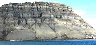
The geology of the Zion and Kolob canyons area includes nine known exposed formations, all visible in Zion National Park in the U.S. state of Utah. Together, these formations represent about 150 million years of mostly Mesozoic-aged sedimentation in that part of North America. Part of a super-sequence of rock units called the Grand Staircase, the formations exposed in the Zion and Kolob area were deposited in several different environments that range from the warm shallow seas of the Kaibab and Moenkopi formations, streams and lakes of the Chinle, Moenave, and Kayenta formations to the large deserts of the Navajo and Temple Cap formations and dry near shore environments of the Carmel Formation.

The exposed geology of the Bryce Canyon area in Utah shows a record of deposition that covers the last part of the Cretaceous Period and the first half of the Cenozoic era in that part of North America. The ancient depositional environment of the region around what is now Bryce Canyon National Park varied from the warm shallow sea in which the Dakota Sandstone and the Tropic Shale were deposited to the cool streams and lakes that contributed sediment to the colorful Claron Formation that dominates the park's amphitheaters.

Colorado Plateau plateau in the southwestern United States

The Colorado Plateau, also known as the Colorado Plateau Province, is a physiographic and desert region of the Intermontane Plateaus, roughly centered on the Four Corners region of the southwestern United States. This province covers an area of 336, 700 km2 (130,000 mi2) within western Colorado, northwestern New Mexico, southern and eastern Utah, and northern Arizona. About 90% of the area is drained by the Colorado River and its main tributaries: the Green, San Juan, and Little Colorado. Most of the remainder of the plateau is drained by the Rio Grande and its tributaries.

1980 eruption of Mount St. Helens Major volcanic eruption in Washington state, US

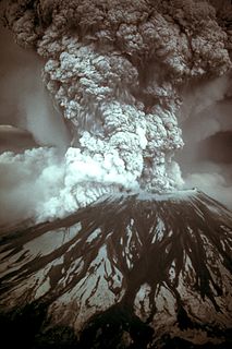
On May 18, 1980, a major volcanic eruption occurred at Mount St. Helens, a volcano located in Skamania County, in the U.S. state of Washington. The eruption was the most significant volcanic eruption to occur in the contiguous 48 U.S. states since the much smaller 1915 eruption of Lassen Peak in California. It has often been declared as the most disastrous volcanic eruption in U.S. history. The eruption was preceded by a two-month series of earthquakes and steam-venting episodes, caused by an injection of magma at shallow depth below the volcano that created a large bulge and a fracture system on the mountain's north slope.

Sevier River river in the United States of America

The Sevier River is a 385-mile (620 km)-long river in the Great Basin of southwestern Utah in the United States. Originating west of Bryce Canyon National Park, the river flows north through a chain of high farming valleys and steep canyons along the west side of the Sevier Plateau, before turning southwest and terminating in the endorheic basin of Sevier Lake in the Sevier Desert. It is used extensively for irrigation along its course, with the consequence that Sevier Lake is usually dry.

Geology of the Capitol Reef area

The exposed geology of the Capitol Reef area presents a record of mostly Mesozoic-aged sedimentation in an area of North America in and around Capitol Reef National Park, on the Colorado Plateau in southeastern Utah.

Thistle, Utah Ghost town in Utah, United States

Thistle is a ghost town in Spanish Fork Canyon in southeastern Utah County, Utah, United States. During the era of steam locomotives, the town's primary industry was servicing trains for the Denver and Rio Grande Western Railroad. The fortunes of the town were closely linked with those of the railroad until the changeover to diesel locomotives, when the town started to decline.

Uinta Basin basin in northeastern Utah and northwestern Colorado in the United States

The Uinta Basin is a physiographic section of the larger Colorado Plateaus province, which in turn is part of the larger Intermontane Plateaus physiographic division. It is also a geologic structural basin in eastern Utah, east of the Wasatch Mountains and south of the Uinta Mountains. The Uinta Basin is fed by creeks and rivers flowing south from the Uinta Mountains. Many of the principal rivers flow into the Duchesne River which feeds the Green River—a tributary of the Colorado River. The Uinta Mountains forms the northern border of the Uinta Basin. They contain the highest point in Utah, Kings Peak, with a summit 13,528 feet above sea level. The climate of the Uinta Basin is semi-arid, with occasionally severe winter cold.

Course of the Colorado River

The Colorado River is a major river of the western United States and northwest Mexico in North America. Its headwaters are in the Rocky Mountains where La Poudre Pass Lake is its source. Located in north central Colorado it flows southwest through the Colorado Plateau country of western Colorado, southeastern Utah and northwestern Arizona where it flows through the Grand Canyon. It turns south near Las Vegas, Nevada, forming the Arizona–Nevada border in Lake Mead and the Arizona–California border a few miles below Davis Dam between Laughlin, Nevada and Needles, California California before entering Mexico in the Colorado Desert. Most of its waters are diverted into the Imperial Valley of Southern California. In Mexico its course forms the boundary between Sonora and Baja California before entering the Gulf of California. This article describes most of the major features along the river.

The Pliocene to Late Neogene Bidahochi Formation, lies at an elevation of about 6,300 feet (1,920 m) to 6,600 feet (2,012 m) at the southeast of the Colorado Plateau; the deposits are from Bidahochi Lake,, and the deposits extend southwards to the region at the north perimeter of the White Mountains of central-east Arizona. Bidahochi Lake is thought to have been a single "large lake, or several shallow, and ephemeral ones." Various fossil types are found; also bird trackways.

2014 Oso mudslide landslide east of Oso, Washington, United States

A major landslide occurred 4 miles (6.4 km) east of Oso, Washington, United States, on March 22, 2014, at 10:37 a.m. local time. A portion of an unstable hill collapsed, sending mud and debris to the south across the North Fork of the Stillaguamish River, engulfing a rural neighborhood, and covering an area of approximately 1 square mile (2.6 km2). Forty-three people were killed and 49 homes and other structures destroyed.

Love Creek is a creek in California. It starts around 1,000 feet above sea level, flows southward through the town of Ben Lomond, California in Santa Cruz County, California, and enters the San Lorenzo River south of Ben Lomond. It is actually on the higher ground side of the business district, which makes the possibility of flooding serious.

Grand Wash Cliffs

The Grand Wash Cliffs extend south-southeast from the Grand Canyon-Parashant National Monument in northwest Arizona west of the Shivwits Plateau south through the Grand Cliffs Wilderness and into the Lake Mead Recreation Area. The Grand Wash Cliffs cross the Grand Canyon where the Colorado River enters Lake Mead. To the south of the Grand Canyon the Grand Wash Cliffs continue past the east side of Grapevine Mesa and then southeast above and east of the Hualapai Valley forming the southwest margin of the Music Mountains.

Willow Creek (Grand and Uintah counties, Utah)

Willow Creek is a major north-flowing stream in Utah, United States, and is a tributary of the Green River. The creek drains a large remote area of the East Tavaputs Plateau, flowing into the Green River south of Ouray.

References

  1. 1 2 3 White, Jonathan L.; Morgan, Matthew L.; Berry, Karen A. (2015). "B-55 The West Salt Creek Landslide: A Catastrophic Rockslide and Rock/Debris Avalanche in Mesa County, Colorado". Colorado Geological Survey. Retrieved 2017-05-05.
  2. USGS Topo Maps for United States (Map). Cartography by United States Geological Survey. ACME Mapper. Retrieved 2017-05-05.
  3. 1 2 3 Coe, Jeffrey A.; et al. (Oct 2014). "The West Salt Creek Rock Avalanche: A Highly Mobile, Complex Landslide in Western Colorado". Geological Society of America. Retrieved 2017-05-05.
  4. Pearce, Matt (2014-05-26). "'Massive' mudslide on Colorado's Grand Mesa leaves three missing". Los Angeles Times. Retrieved 2017-05-05.
  5. 1 2 3 Harmon, Gary (2015-10-01). "Study: West Salt Creek landslide path, pond changing". The Daily Sentinel. Retrieved 2017-05-06.
  6. 1 2 3 4 5 6 7 "Reconstruction of an Avalanche: The West Salt Creek Rock Avalanche, Colorado, May 25, 2014". U.S. Geological Survey. Retrieved 2017-05-05.
  7. 1 2 Coe, Jeffrey A.; et al. "Rock-avalanche dynamics revealed by large-scale field mapping and seismic signals at a highly mobile avalanche in the West Salt Creek valley, western Colorado". Geosphere. Retrieved 2017-05-05.
  8. 1 2 3 4 Lofholm, Nancy (2016-05-26). "Colorado mudslide: Mesa County town of Collbran fears for three missing men". Denver Post. Retrieved 2017-05-05.
  9. 1 2 3 "West Salt Creek Landslide". GeologyIn. Retrieved 2017-05-05.
  10. "Grand Mesa Landslide: West Salt Creek, Colorado, Sunday, May 25, 2014". Colorado Mesa University. Retrieved 2017-05-04.
  11. 1 2 3 Thatcher, Chad (2014-09-16). "Experts studying West Salt Creek landslide expect more to occur on Grand Mesa". Post Independent.
  12. Geological Society of America (2016-02-29). "Massive 2014 Colorado avalanche examined". ScienceDaily. Retrieved 2017-05-05.
  13. Oravetz, Janet; Villanueva, Raquel (2014-05-26). "3 missing in Colorado mudslide identified". USA Today. Retrieved 2017-05-05.
  14. Harmon, Gary (2016-05-15). "West Salt Creek slide lake leaks, officials report". The Daily Sentinel. Retrieved 2017-05-05.
  15. Perkins, Kelsey (2015-04-28). "Update on West Salt Creek landslide - could we see a second slide?". KKCO. Retrieved 2017-05-05.
  16. "Pond breach gashes slide". The Daily Sentinel. 2016-05-27. Retrieved 2017-05-06.
  17. Paul, Jesse (2016-05-27). "Landslide stabilizes near Collbran; Mesa County continues alert". Denver Post. Retrieved 2017-05-04.
  18. "West Salt Creek Landslide". Colorado Geological Survey. Retrieved 2017-05-05.
  19. "USGS Gage #09096570 West Salt Creek Landslide Sag Pool near Collbran, CO". National Water Information System. U.S. Geological Survey. Retrieved 2017-05-05.

Coordinates: 39°10′07″N107°50′54″W / 39.16861°N 107.84833°W / 39.16861; -107.84833