Related Research Articles

Burkina Faso is a landlocked Sahel country that shares borders with six nations. It lies between the Sahara desert and the Gulf of Guinea, south of the loop of the Niger River, mostly between latitudes 9° and 15°N, and longitudes 6°W and 3°E. The land is green in the south, with forests and fruit trees, and semi-arid in the north. Most of central Burkina Faso lies on a savanna plateau, 198–305 metres (650–1,001 ft) above sea level, with fields, brush, and scattered trees. Burkina Faso's game preserves – the most important of which are Arly, Nazinga, and W National Park—contain lions, elephants, hippopotamus, monkeys, common warthogs, and antelopes. Previously the endangered painted hunting dog, Lycaon pictus occurred in Burkina Faso, but, although the last sightings were made in Arli National Park, the species is considered extirpated from Burkina Faso.

Senegal, officially the Republic of Senegal, is the westernmost country in West Africa, situated on the Atlantic Ocean coastline. Senegal is bordered by Mauritania to the north, Mali to the east, Guinea to the southeast and Guinea-Bissau to the southwest. Senegal nearly surrounds The Gambia, a country occupying a narrow sliver of land along the banks of the Gambia River, which separates Senegal's southern region of Casamance from the rest of the country. Senegal also shares a maritime border with Cape Verde. Senegal's economic and political capital is Dakar.

Senegal is a coastal West African nation located 14 degrees north of the equator and 14 degrees west of the Prime Meridian. The country's total area is 196,190 km2 of which 192,000 km2 is land and 4,190 km2 is water.
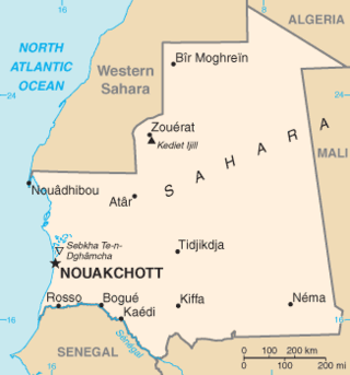
Mauritania, a country in the Western Region of the continent of Africa, is generally flat, its 1,030,700 square kilometres forming vast, arid plains broken by occasional ridges and clifflike outcroppings. Mauritania is the world’s largest country lying entirely below an altitude of 1,000 metres (3,300 ft). It borders the North Atlantic Ocean, between Senegal and Western Sahara, Mali and Algeria. It is considered part of both the Sahel and the Maghreb. A series of scarps face southwest, longitudinally bisecting these plains in the center of the country. The scarps also separate a series of sandstone plateaus, the highest of which is the Adrar Plateau, reaching an elevation of 500 metres or 1,640 feet. Spring-fed oases lie at the foot of some of the scarps. Isolated peaks, often rich in minerals, rise above the plateaus; the smaller peaks are called Guelbs and the larger ones Kedias. The concentric Guelb er Richat is a prominent feature of the north-central region. Kediet ej Jill, near the city of Zouîrât, has an elevation of 915 metres or 3,002 feet and is the highest peak.

Mali is a landlocked nation in West Africa, located southwest of Algeria, extending south-west from the southern Sahara Desert through the Sahel to the Sudanian savanna zone. Mali's size is 1,240,192 square kilometers.

The Sahel region or Sahelian acacia savanna is a biogeographical region in Africa. It is the transition zone between the more humid Sudanian savannas to its south and the drier Sahara to the north. The Sahel has a hot semi-arid climate and stretches across the southernmost latitudes of North Africa between the Atlantic Ocean and the Red Sea. Although geographically located in the tropics, the Sahel does not have a tropical climate.

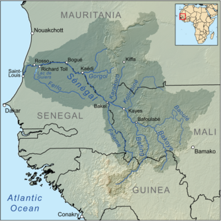
Kayes is a city in western Mali on the Sénégal River with a population of 127,368 at the 2009 census. Kayes is the capital of the administrative region of the same name. The name "Kayes" comes from the Soninke word "karré", which describes a low humid place that floods in rainy season. The city is located 420 kilometres (260 mi) northwest of the capital Bamako.
Joal-Fadiouth is a town and commune in the Thiès Region at the end of the Petite Côte of Senegal, south-east of Dakar.

The Permanent Interstate Committee for Drought Control in the Sahel is an international organization consisting of countries in the Sahel region of Africa.

The Sahel region of Africa has long experienced a series of historic droughts, dating back to at least the 17th century. The Sahel region is a climate zone sandwiched between the Sudanian Savanna to the south and the Sahara desert to the north, across West and Central Africa. While the frequency of drought in the region is thought to have increased from the end of the 19th century, three long droughts have had dramatic environmental and societal effects upon the Sahel nations. Famine followed severe droughts in the 1910s, the 1940s, and the 1960s, 1970s and 1980s, although a partial recovery occurred from 1975-80. The most recent drought occurred in 2012.
The Great Green Wall or Great Green Wall of the Sahara and the Sahel is a project adopted by the African Union in 2007, initially conceived as a way to combat desertification in the Sahel region and hold back expansion of the Sahara desert, by planting a wall of trees stretching across the entire Sahel from Djibouti, Djibouti to Dakar, Senegal. The original dimensions of the "wall" were to be 15 km wide and 7,775 km long, but the program expanded to encompass nations in both northern and western Africa. The concept evolved into promoting water harvesting techniques, greenery protection and improving indigenous land use techniques, aimed at creating a mosaic of green and productive landscapes across North Africa. Later it adopted the view that desert boundaries change based on rainfall variations.
The 2009 West Africa floods are a natural disaster that began in June 2009 as a consequence of exceptionally heavy seasonal rainfall in large areas of West Africa. Several rivers, including the Pendjari, Niger, Volta and Senegal rivers, broke their banks, causing destruction of houses, bridges, roads and crops. The floods are reported to have affected 940,000 people across 12 countries, including Burkina Faso, Benin, Ghana, Niger, Senegal, Guinea, and caused the deaths of at least 193 people. In Burkina Faso, one of the most affected countries, 150,000 people fled their homes, mostly in the capital Ouagadougou where rainfall in one day was equal to 25% of normal annual rainfall for the whole country.
A large-scale, drought-induced famine occurred in Africa's Sahel region and many parts of the neighbouring Sénégal River Area from February to August 2010. It is one of many famines to have hit the region in recent times.
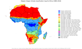
The climate of Africa is a range of climates such as the equatorial climate, the tropical wet and dry climate, the tropical monsoon climate, the semi-arid climate, the desert climate, the humid subtropical climate, and the subtropical highland climate. Temperate climates are rare across the continent except at very high elevations and along the fringes. In fact, the climate of Africa is more variable by rainfall amount than by temperatures, which are consistently high. African deserts are the sunniest and the driest parts of the continent, owing to the prevailing presence of the subtropical ridge with subsiding, hot, dry air masses. Africa holds many heat-related records: the continent has the hottest extended region year-round, the areas with the hottest summer climate, the highest sunshine duration, and more.

Climate change in Africa is an increasingly serious threat as Africa is among the most vulnerable continents to the effects of climate change. Some sources even classify Africa as "the most vulnerable continent on Earth". Climate change and climate variability will likely reduce agricultural production, food security and water security. As a result, there will be negative consequences on people's lives and sustainable development in Africa.
Senegal's environmental issues are varied. According to the CIA world factbook pressing problems exist with: diminishing wildlife populations which are threatened by poaching, deforestation, overgrazing, soil erosion, desertification, and overfishing.

Climate change in Senegal will have wide reaching impacts on many aspects of life in Senegal. Climate change will cause an increase in average temperatures over west Africa by between 1.5 and 4 °C by mid-century, relative to 1986–2005. Projections of rainfall indicate an overall decrease in rainfall and an increase in intense mega-storm events over the Sahel. The sea level is expected to rise faster in West Africa than the global average. Although Senegal is currently not a major contributor to global greenhouse gas emissions, it is one of the countries most vulnerable to climate change.
The 2020 East Africa floods were a natural disaster in Rwanda, Kenya, Somalia, Burundi, Ethiopia, Uganda, Democratic Republic of Congo, Djibouti and Tanzania, affecting at least 700,000 people. They began when excessive rains began falling in March, leading to massive flooding and landslides. They caused more than 430 deaths, notably in Kenya and Rwanda. In the fall another round of floods hit the African Sahel.
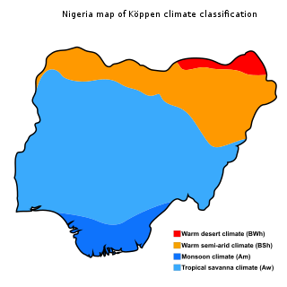
The climate of Nigeria is mostly tropical. Nigeria has three distinct climatic zones, two seasons, and an average temperature ranging between 21 °C and 35 °C. Two major elements determine the temperature in Nigeria: the altitude of the sun and the atmosphere's transparency. Its rainfall is mediated by three distinct conditions including convectional, frontal, and orographical determinants. Statistics from the World Bank Group showed Nigeria's annual temperature and rainfall variations, the nation's highest average annual mean temperature was 28.1 °C in 1938, while its wettest year was 1957 with an annual mean rainfall of 1,441.45mm.
Floods in Ghana is a list of flood incidents that has destroyed properties and led to loss of lives. Floods are caused by excessive rainfall and dam spillages.
References
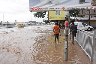
- ↑ Celestial, Julie (September 12, 2020). "Exceptional rainfall and record floods hit African Sahel". The Watchers.
- ↑ "Senegal – State of Emergency After Deadly Floods". Floodlist. 7 September 2020.
| | This article about a flood is a stub. You can help Wikipedia by expanding it. |
| | This Africa-related article is a stub. You can help Wikipedia by expanding it. |