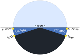
Twilight is light produced by sunlight scattering in the upper atmosphere, when the Sun is below the horizon, which illuminates the lower atmosphere and the Earth's surface. The word twilight can also refer to the periods of time when this illumination occurs.
The 41st parallel north is a circle of latitude that is 41 degrees north of the Earth's equatorial plane. It crosses Europe, the Mediterranean Sea, Asia, the Pacific Ocean, North America, and the Atlantic Ocean.
The 40th parallel north is a circle of latitude that is 40 degrees north of the Earth's equatorial plane. It crosses Europe, the Mediterranean Sea, Asia, the Pacific Ocean, North America, and the Atlantic Ocean.
The 30th parallel north is a circle of latitude that is 30 degrees north of the Earth's equatorial plane. It stands one-third of the way between the equator and the North Pole and crosses Africa, Asia, the Pacific Ocean, North America and the Atlantic Ocean. The parallel is used in some contexts to delineate Europe or what is associated with the continent of Europe as a southernmost limit, e.g. to qualify for membership of the European Broadcasting Union.
The 45th parallel north is a circle of latitude that is 45 degrees north of Earth's equator. It crosses Europe, Asia, the Pacific Ocean, North America, and the Atlantic Ocean. The 45th parallel north is often called the halfway point between the equator and the North Pole, but the true halfway point is 16.0 km (9.9 mi) north of it because Earth is an oblate spheroid; that is, it bulges at the equator and is flattened at the poles.

The 10th parallel north is a circle of latitude that is 10 degrees north of the Earth's equatorial plane. It crosses Africa, the Indian Ocean, the Indian Subcontinent, Southeast Asia, the Pacific Ocean, Central America, South America and the Atlantic Ocean.

The 20th parallel north is a circle of latitude that is 20 degrees north of the Earth's equatorial plane. It crosses Africa, Asia, the Indian Ocean, the Pacific Ocean, North America, the Caribbean and the Atlantic Ocean.
The 50th parallel north is a circle of latitude that is 50 degrees north of the Earth's equatorial plane. It crosses Europe, Asia, the Pacific Ocean, North America, and the Atlantic Ocean.
The 60th parallel north is a circle of latitude that is 60 degrees north of Earth's equator. It crosses Europe, Asia, the Pacific Ocean, North America, and the Atlantic Ocean.

The 70th parallel north is a circle of latitude that is 70 degrees north of the Earth's equatorial plane, in the Arctic. It crosses the Atlantic Ocean, Europe, Asia and North America, and passes through some of the southern seas of the Arctic Ocean.
The 30th parallel south is a circle of latitude that is 30 degrees south of the Earth's equator. It stands one-third of the way between the equator and the South Pole and crosses Africa, the Indian Ocean, Australia, the Pacific Ocean, South America and the Atlantic Ocean.
The 50th parallel south is a circle of latitude that is 50 degrees south of the Earth's equatorial plane. It crosses the Atlantic Ocean, the Indian Ocean, the Pacific Ocean and South America.
The 60th parallel south is a circle of latitude that is 60 degrees south of Earth's equatorial plane. No land lies on the parallel—it crosses nothing but ocean. The closest land is a group of rocks north of Coronation Island of the South Orkney Islands, which are about 54 km south of the parallel, and Thule Island and Cook Island of the South Sandwich Islands, which both are about 57 km north of the parallel.

The 35th parallel south is a circle of latitude that is 35 degrees south of the Earth's equatorial plane. It crosses the Atlantic Ocean, the Indian Ocean, Australasia, the Pacific Ocean and South America.
The meridian 140° east of Greenwich is a line of longitude that extends from the North Pole across the Arctic Ocean, Asia, the Pacific Ocean, Australasia, the Indian Ocean, the Southern Ocean, and Antarctica to the South Pole.
The equator is a circle of latitude that divides a spheroid, such as Earth, into the Northern and Southern hemispheres. On Earth, the Equator is an imaginary line located at 0 degrees latitude, about 40,075 km (24,901 mi) in circumference, halfway between the North and South poles. The term can also be used for any other celestial body that is roughly spherical.
The 41st parallel south is a circle of latitude that is 41 degrees south of the Earth's equatorial plane. It crosses the Atlantic Ocean, the Indian Ocean, Australasia, the Pacific Ocean and South America.
The 57th parallel south is a circle of latitude that is 57 degrees south of the Earth's equatorial plane. No land lies on the parallel — it crosses nothing but ocean.
The 57th parallel north is a circle of latitude that is 57 degrees north of the Earth's equatorial plane. It crosses Europe, Asia, the Pacific Ocean, North America, and the Atlantic Ocean.

A total solar eclipse occurred at the Moon's ascending node on 3 November 2013. It was a hybrid eclipse of the Sun with a magnitude of 1.0159, with a small portion over the western Atlantic Ocean at sunrise as an annular eclipse, and the rest of the path as a narrow total solar eclipse. A solar eclipse occurs when the Moon passes between Earth and the Sun, thereby totally or partly obscuring the image of the Sun for a viewer on Earth. A hybrid solar eclipse occurs when the Moon's apparent diameter is smaller than the Sun's in sunrise and sunset, but at Greatest Eclipse the Moon's apparent diameter is larger than the Sun's.

