Related Research Articles
Year 499 (CDXCIX) was a common year starting on Friday of the Julian calendar. At the time, it was known as the Year of the Consulship of Iohannes without colleague. The denomination 499 for this year has been used since the early medieval period, when the Anno Domini calendar era became the prevalent method in Europe for naming years.
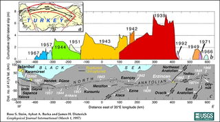
The North Anatolian Fault (NAF) is an active right-lateral strike-slip fault in northern Anatolia, and is the transform boundary between the Eurasian Plate and the Anatolian Plate. The fault extends westward from a junction with the East Anatolian Fault at the Karliova Triple Junction in eastern Turkey, across northern Turkey and into the Aegean Sea for a length of 1200−1500 kilometers. It runs about 20 km south of Istanbul. The North Anatolian Fault is similar in many ways to the San Andreas Fault in California. Both are continental transforms with similar lengths and slip rates. The Sea of Marmara near Istanbul is an extensional basin similar to the Salton Trough in California, where a releasing bend in the strike slip system creates a pull-apart basin.

Niksar, historically known as Neocaesarea (Νεοκαισάρεια), is a city in Tokat Province, Turkey. It is the seat of Niksar District. Its population is 37,017 (2022). It was settled by many empires. Niksar is known as "Çukurova of North-Anatolia" due to its production of many kinds of fruits and vegetables. On May 2, 2018, Niksar was included in the World Heritage tentative list.
An earthquake struck Turkey's eastern Erzincan Province at 1:57:23 a.m. on 27 December 1939 local time with a moment magnitude of 7.8Mw and a maximum Mercalli intensity of XII (Extreme). It is the joint second most-powerful earthquake recorded in Turkey, tied with the 2023 Turkey–Syria earthquake. Only the 1668 North Anatolia earthquake was more powerful. This was one of the largest in a sequence of violent shocks to affect Turkey along the North Anatolian Fault between 1939 and 1999. Surface rupturing, with a horizontal displacement of up to 3.7 meters, occurred in a 360 km long segment of the North Anatolian Fault Zone. The earthquake was the most severe natural loss of life in Turkey in the 20th century, with 32,968 dead, and some 100,000 injured.
The 1138 Aleppo earthquake was among the deadliest earthquakes in history. Its name was taken from the city of Aleppo, in northern Syria, where the most casualties were sustained. The earthquake also caused damage and chaos to many other places in the area around Aleppo. The quake occurred on 11 October 1138 and was preceded by a smaller quake on the 10th. It is frequently listed as the third deadliest earthquake in history, following on from the Shensi and Tangshan earthquakes in China. However, the figure of 230,000 deaths reported by Ibn Taghribirdi in the fifteenth century is most likely based on a historical conflation of this earthquake with earthquakes in November 1137 on the Jazira plain and the large seismic event of 30 September 1139 in the Transcaucasian city of Ganja.
Nicopolis was a Roman colony in Lesser Armenia founded by Pompey in 63 BC after conquering the Kingdom of Pontus in the Third Mithridatic War. It became part of the Roman province of Armenia Prima. Today, the city of Koyulhisar in northeastern Turkey occupies the site.
On 13 March 1992, a moment magnitude 6.7 earthquake struck eastern Turkey. It had a maximum Mercalli intensity of IX (Violent) and occurred along the North Anatolian Fault. At least 498 people died, roughly 2,000 were injured, and an unknown number of people went missing. Total financial losses were between $13.5 million and $750 million.
The 1943 Tosya–Ladik earthquake occurred at 01:20 local time on 27 November, near Tosya, Kastamonu Province, in northern Turkey. The earthquake had an estimated moment magnitude of 7.5–7.7 and a maximum felt intensity of XI (Catastrophic) on the MSK-64 scale. Its effects were observed for over 45,000 km2. The earthquake was felt in Trabzon, Isparta, Elazığ, Zonguldak and Yozgat. Damage was seen in Kastamonu, Çankırı, Çorum, Amasya, Samsun, Tokat, Sinop and Ordu. As a result of the earthquake, more than 2,500 were killed and 5,000 were injured.
The 557 Constantinople earthquake took place on the night of December 14. This earthquake, described in the works of Agathias, John Malalas, and Theophanes the Confessor, caused great damage to Constantinople, then capital of the Byzantine Empire in a region frequently afflicted with earthquakes. More minor quakes had preceded the large event, including two in April and October respectively. The main quake in December was of unparalleled ferocity, and "almost completely razed" the city. It caused damage to the Hagia Sophia which contributed to the collapse of its dome the next year, as well as damaging the walls of Constantinople to the extent that Hun invaders were able to penetrate it with ease the following season.
An earthquake occurred in the northern Aegean Sea between Greece and Turkey on May 24, 2014. It had a moment magnitude of 6.9 and a maximum Mercalli intensity of VIII (Severe). Serious damage was reported on the Turkish island of Imbros and the cities of Edirne and Çanakkale, as well as on the Greek island of Lemnos. The earthquake was felt in Bulgaria and southern Romania. Several aftershocks followed the main shock, the strongest measuring 5.3 ML. This aftershock struck the Gulf of Saros at 12:31 local time.
The 461 Apahunik' earthquake affected the province of Apahunik', located to the north of Lake Van, in Anatolia.
The 363 Arsakawan earthquake took place c. 363. It affected the cities of Arsakawan and Salat.
The 139 Mcurn earthquake is listed in bibliographical records of seismology as having affected the city of Mcurn.

The 1766 Istanbul earthquake was a strong earthquake with epicenter in the eastern part of the Sea of Marmara, in the Çınarcık Basin which occurred in the early hours of Thursday morning, 22 May 1766. The earthquake had an estimated magnitude of 7.1 on the surface wave magnitude scale, and caused effects in a vast area extending from Izmit to Rodosto. In this area, the earthquake was followed by a tsunami which caused significant damage. The earthquake of 1766 was the last major earthquake to rock Constantinople because of a rupture of the North Anatolian Fault in the Marmara region.
The 602 Surb Karapet Monastery earthquake took place in 602 and affected the Surb Karapet Monastery, located in the district of Taron.
The 743 Caspian Gates earthquake reportedly took place in the year 743 or 744 in the Caspian Gates. The location is identified with either Derbent, Russia or Talis, Iran.
The 840 Erzurum earthquake reportedly took place in the city of Qaliqala.
Northern Anatolia was struck by a large earthquake on 17 August 1668 in the late morning. It had an estimated magnitude in the range 7.8–8.0 Ms and the maximum felt intensity was IX on the Modified Mercalli intensity scale. The epicenter of the earthquake was on the southern shore of Ladik Lake. It caused widespread damage from as far west as Bolu and as far east as Erzincan, resulting in about 8,000 deaths. It is thought to be the most powerful earthquake in Turkey.
The 995 Balu earthquake took place in 995 or 996. It reportedly affected the Armenian areas of Balu, Cop'k, Palnatun, and the districts of Hasteank and Xorjean.
The 1899 Aydın–Denizli earthquake which struck present-day Turkey on September 30 resulted in between 1,117 and 1,470 fatalities. Heavy damage was reported in the provinces of Aydın and Denizli. The shallow normal-faulting earthquake had a maximum Modified Mercalli intensity of IX (Violent). Estimates of the seismic magnitude range from 6.5 to 7.1 Mw.
References
- 1 2 3 4 5 6 7 8 9 10 11 12 13 14 15 16 Guidoboni, Traina, 1995
- ↑ Stein, R. S.; Barka, A. A.; Dieterich, J. H. (1997). "Progressive failure on the North Anatolian fault since 1939 by earthquake stress triggering". Geophysical Journal International . 128 (3): 594–604. Bibcode:1997GeoJI.128..594S. doi: 10.1111/j.1365-246x.1997.tb05321.x .
- ↑ Fraser, J.G.; hubert-Ferrari, A.; Verbeeck, K.; Garcia-Moreno, D.; Avsar, U.; Maricq, N.; Coudijzer, A.; Vlamynck, N.; Vanneste, K. (2012). "A 3000-year record of surface-rupturing earthquakes at Günalan: variable fault-rupture lengths along the 1939 Erzincan earthquake-rupture segment of the North Anatolian Fault, Turkey". Annals of Geophysics. 55 (5). doi:10.4401/ag-4884. hdl: 1854/LU-3152523 .